
Putney, Vermont facts for kids
Quick facts for kids
Putney, Vermont
|
|
|---|---|

Sacketts Brook in downtown Putney (2009)
|
|

Putney, Vermont
|
|
| Country | United States |
| State | Vermont |
| County | Windham |
| Communities |
|
| Area | |
| • Total | 26.8 sq mi (69.4 km2) |
| • Land | 26.8 sq mi (69.4 km2) |
| • Water | 0.0 sq mi (0.0 km2) |
| Elevation | 404 ft (123 m) |
| Population
(2020)
|
|
| • Total | 2,617 |
| • Density | 98/sq mi (37.7/km2) |
| Time zone | UTC−5 (Eastern (EST)) |
| • Summer (DST) | UTC−4 (EDT) |
| ZIP Code |
05346
|
| Area code(s) | 802 |
| FIPS code | 50-57700 |
| GNIS feature ID | 1462181 |
Putney is a town in Windham County, Vermont, United States. In 2020, about 2,617 people lived there.
The town's historic center is known as the Putney Village Historic District. It is listed on the National Register of Historic Places because of its important history.
Contents
History of Putney
On December 26, 1753, a group led by Colonel Josiah Willard asked for a special document called a charter to create Putney. Governor Benning Wentworth gave them this charter on the same day. He was acting under the power of King George II of Great Britain.
However, many people did not start settling in Putney until after the French and Indian War ended in 1763.
The town grew on a large flat area next to the Connecticut River. This spot was above where Sacketts Brook flows into the river. A small waterfall on Sacketts Brook was perfect for early mills, which used water power. The main village grew up around these mills.
Putney did not have many strong waterfalls, so it was mostly skipped by the Industrial Revolution. This was a time in the mid-1800s when many towns grew quickly with new factories. Because of this, Putney stayed mostly a farming area. The buildings in the village show styles like Federal and Greek Revival. These styles were popular when the town was growing the most, from the late 1700s to the mid-1800s.
|
||||||||||||||||||||||||||||||||||||||||||||||||||||||||||||||||||||||||||||||||||||||||||||||||||||||||||||
Geography and Location
Putney covers about 26.8 square miles (69.4 square kilometers) of land. Only a tiny bit of this area is water. The highest point in town is Putney Mountain, which is 1,657 feet (505 meters) above sea level.
Putney shares its borders with other towns:
- Dummerston to the south.
- Westminster to the north.
- Brookline to the west.
The Connecticut River forms Putney's eastern border. This river separates Putney from Westmoreland, New Hampshire. The main village of Putney is in the southern part of the town. It is located along U.S. Route 5 and Sacketts Brook. Putney is about 10 miles (16 km) north of Brattleboro. It is also about 25 miles (40 km) northwest of Keene, New Hampshire.
Transportation in Putney
Two important roads go through Putney: U.S. Route 5 and Interstate 91. You can get to Putney from Interstate 91 at Exit 4. This exit is right on the border between Putney and Dummerston.
The New England Central Railroad also has train tracks that run through the town. The Vermonter passenger train, run by Amtrak, goes through Putney. However, it does not stop in town. The closest train stations are Bellows Falls to the north and Brattleboro to the south.
Education in Putney
Putney is home to several schools, offering different types of learning experiences:
- The Grammar School is a private school for students from Preschool to 8th grade. It focuses on learning about nature.
- The Putney School is a private high school where students can live at the school or attend during the day.
- Landmark College is a special college. It is the first college made just for students who have learning disabilities.
- The Greenwood School is a boarding school for boys in grades 6–12. It helps boys who have dyslexia or other language-based learning challenges.
- Putney Central School is the town's public school. It serves students from Pre-K through 8th grade.

Notable People from Putney
Many interesting people have lived in or are connected to Putney:


- George Aiken: A US Senator and a former Governor of Vermont.
- Pete Bernhard: A musician and member of the band The Devil Makes Three.
- George M. Darrow: A plant expert, especially known for his work with small fruits and strawberries.
- Fernando Gerassi: A painter.
- Bob Gray: An Olympic skier.
- William B. Gray: A United States Attorney for Vermont.
- William Haile: A successful businessman and politician.
- Carmelita Hinton: A forward-thinking educator who started The Putney School.
- Reid Hoffman: An entrepreneur who founded LinkedIn. He also invests in new companies and is a graduate of The Putney School.
- John Irving: A famous author and Academy Award winner. He taught at Windham College while writing his first book.
- Manon Kahle: An actress.
- Melissa Leo: An actress.
- Prescott Metcalf: A well-known businessman and former mayor of Erie, Pennsylvania.
- Errol Morris: A documentary filmmaker who has won a MacArthur Fellowship and an Academy Award. He also graduated from The Putney School.
- John Humphrey Noyes: An American who believed in creating perfect communities.
- Peter Shumlin: The 81st Governor of Vermont, serving from 2011 to 2017.
- Cyndy Szekeres: A children's book author and illustrator who has lived in Putney since 1974.
- Jody Williams: She won the Nobel Peace Prize in 1997.
- John Henry Williams: The only son of the famous baseball player Ted Williams.
Notable Places to Visit
Putney has several historic and interesting places:
- Theophilus Crawford House: A historic house built around 1808. It was added to the National Register of Historic Places ("NRHP") in 1995.
- East Putney Brook Stone Arch Bridge: This bridge was built in 1902 and added to the NRHP in 1976.
- Putney Village Historic District: This is the old, important part of Putney Village. It was added to the NRHP in 1986.
- Sabin-Wheat Farm: A farm that started around 1790. It was added to the NRHP in 2004.
- Sacketts Brook Stone Arch Bridge: This bridge is also known as the Hi-Lo Biddy Stone Arch Bridge. It was built in 1905 and added to the NRHP in 1976.


- Putney Village Historic District
-
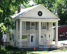
120 Main Street was built c. 1835 in the Greek Revival style
-
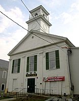
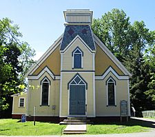
The former Putney Federated Church, built in 1841, now houses Next Stage Arts and the Putney Historical Society
-
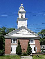
Our Lady of Mercy Roman Catholic Church, formerly the Putney Methodist Church, built in 1842
-
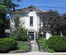
Putney Town Hall, built in 1871
-
Putney Community Center, built in 1884 as the Putney Baptist Church
-
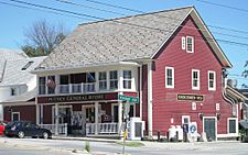
Putney General Store, built 1840–1900
-
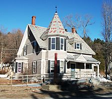
79 Main Street was built c. 1905
-
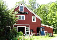
Sandglass Puppet Theater was built in 1915 as a livery stable


See also
 In Spanish: Putney (Vermont) para niños
