
Surry, New Hampshire facts for kids
Quick facts for kids
Surry, New Hampshire
|
||
|---|---|---|
|
Town
|
||

Town Hall
|
||
|
||

Location in Cheshire County, New Hampshire
|
||
| Country | United States | |
| State | New Hampshire | |
| County | Cheshire | |
| Incorporated | 1769 | |
| Communities |
|
|
| Area | ||
| • Total | 16.0 sq mi (41.4 km2) | |
| • Land | 15.7 sq mi (40.6 km2) | |
| • Water | 0.3 sq mi (0.8 km2) 1.97% | |
| Elevation | 581 ft (177 m) | |
| Population
(2020)
|
||
| • Total | 820 | |
| • Density | 52/sq mi (20.2/km2) | |
| Time zone | UTC−5 (Eastern) | |
| • Summer (DST) | UTC−4 (Eastern) | |
| ZIP Code |
03431
|
|
| Area code(s) | 603 | |
| FIPS code | 33-75300 | |
| GNIS feature ID | 0873733 | |

Surry is a small town located in Cheshire County, New Hampshire, in the United States. In 2020, the town had a population of 820 people. This was an increase from 732 people counted in 2010.
Contents
History of Surry
Surry was officially started in 1769. It was named after Charles Howard, 10th Duke of Norfolk, who was also the Earl of Surrey. The first time a count of people was done in Surry was in 1790. At that time, 448 people lived there.
Geography and Nature
Surry covers a total area of about 41.4 square kilometers (16 square miles). Most of this area, about 40.6 square kilometers (15.7 square miles), is land. The rest, 0.8 square kilometers (0.3 square miles), is water. This means water makes up almost 2% of the town's total area.
The highest point in Surry is on Derry Hill. This spot reaches an elevation of about 1,555 feet (474 meters).
Surry Dam and Lake
The Ashuelot River flows through Surry. The Surry Dam is built on this river in the southern part of town. This dam creates Surry Mountain Lake. The lake is a popular place for fun outdoor activities.
40 Foot Falls
You can find a beautiful waterfall in Surry called 40 Foot Falls. It is located on Merriam Brook and can be seen from Joslin Road.
Neighboring Towns
Surry shares its borders with several other towns:
- To the north: Alstead
- To the east: Gilsum
- To the south: Keene
- To the southwest: Westmoreland
- To the northwest: Walpole
Population Changes
The number of people living in Surry has changed over many years. Here's a look at the population from 1790 to 2020:
| Historical population | |||
|---|---|---|---|
| Census | Pop. | %± | |
| 1790 | 448 | — | |
| 1800 | 569 | 27.0% | |
| 1810 | 564 | −0.9% | |
| 1820 | 570 | 1.1% | |
| 1830 | 539 | −5.4% | |
| 1840 | 481 | −10.8% | |
| 1850 | 556 | 15.6% | |
| 1860 | 389 | −30.0% | |
| 1870 | 318 | −18.3% | |
| 1880 | 326 | 2.5% | |
| 1890 | 270 | −17.2% | |
| 1900 | 250 | −7.4% | |
| 1910 | 213 | −14.8% | |
| 1920 | 200 | −6.1% | |
| 1930 | 198 | −1.0% | |
| 1940 | 236 | 19.2% | |
| 1950 | 291 | 23.3% | |
| 1960 | 362 | 24.4% | |
| 1970 | 507 | 40.1% | |
| 1980 | 656 | 29.4% | |
| 1990 | 667 | 1.7% | |
| 2000 | 673 | 0.9% | |
| 2010 | 732 | 8.8% | |
| 2020 | 820 | 12.0% | |
| U.S. Decennial Census | |||
In 2000, there were 673 people living in Surry. Most of the people were White (about 98%). A small number were Native American, Asian, or from other backgrounds. About 1.5% of the population was Hispanic or Latino.
The average age of people in Surry in 2000 was 44 years old. About 21% of the population was under 18 years old.
Famous People from Surry
- Amos Pollard (1803–1836) was a chief surgeon. He was known for helping defend the Alamo in Texas. He grew up in Surry.
Images for kids
-
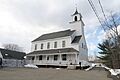
The Town Hall in Surry, New Hampshire.
-

The official seal of the town of Surry.
-
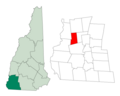
A map showing Surry's location in Cheshire County, New Hampshire.
See also
 In Spanish: Surry (Nuevo Hampshire) para niños
