
Gilsum, New Hampshire facts for kids
Quick facts for kids
Gilsum, New Hampshire
|
|
|---|---|
|
Town
|
|

Bird's-eye view in 1908
|
|

Location in Cheshire County, New Hampshire
|
|
| Country | United States |
| State | New Hampshire |
| County | Cheshire |
| Incorporated | 1763 |
| Villages |
|
| Area | |
| • Total | 16.69 sq mi (43.23 km2) |
| • Land | 16.67 sq mi (43.17 km2) |
| • Water | 0.02 sq mi (0.06 km2) 0.13% |
| Elevation | 873 ft (266 m) |
| Population
(2020)
|
|
| • Total | 752 |
| • Density | 45/sq mi (17.4/km2) |
| Time zone | UTC-5 (Eastern) |
| • Summer (DST) | UTC-4 (Eastern) |
| ZIP code |
03448
|
| Area code(s) | 603 |
| FIPS code | 33-29220 |
| GNIS feature ID | 0873605 |
Gilsum is a small town located in Cheshire County, New Hampshire, in the United States. In 2020, about 752 people lived there. It is known for a beautiful spot called Bear's Den Natural Area. Gilsum also includes a part called Gilsum Lower Village.
Contents
History of Gilsum
The land where Gilsum now stands was first named "Boyle" in 1752. This was after Richard Boyle, a rich Earl. But there were wars happening, like the French and Indian War, so no one could settle there safely.
Later, in 1763, Governor Benning Wentworth gave the land a new name: Gilsum. This name was a mix of the last names of two important people, Samuel Gilbert and Thomas Sumner. The first person to settle in Gilsum was Josiah Kilburn in 1764. He came from Hebron, Connecticut.
Early Industries and Mining
The Ashuelot River was very important for Gilsum. Its strong water flow powered woolen mills. By 1859, the town had 668 people. There was also a factory that made bobbins (parts for spinning machines), a chair factory, and a place that made leather.
Gilsum used to be a big center for mining special rocks. People dug for mica and feldspar there. You could also find beautiful crystals like beryl, tourmaline, and quartz. Today, Gilsum is home to the W.S. Badger Company. They make natural balms and remedies.
Gilsum Stone Arch Bridge
The town has a famous landmark called the Stone Arch Bridge. It was finished in 1863. This bridge is special because it has the highest arch (36 feet, 6 inches) of any bridge in New Hampshire that was built without mortar. In 1989, it was added to the National Register of Historic Places, which means it's an important historical site.
-
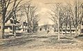
Main Street c. 1910
-
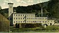
Woolen mill in 1911
-
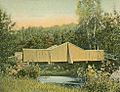
Polley Bridge in 1907
-
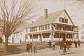
The Ashuelot Hotel c. 1896


Geography of Gilsum
According to the United States Census Bureau, Gilsum covers a total area of about 43.2 square kilometers (16.7 square miles). Only a very small part, about 0.06 square kilometers (0.02 square miles), is water.
The highest point in Gilsum is an unnamed hill. It is about 505 meters (1,657 feet) above sea level. The Ashuelot River flows through Gilsum. All the water in the town eventually flows into the Connecticut River watershed. This means it's part of the larger area that drains into the Connecticut River.
The town is connected by New Hampshire Route 10.
Neighboring Towns
Gilsum is surrounded by several other towns:
- Alstead (to the north)
- Marlow (to the northeast)
- Stoddard (to the east)
- Sullivan (to the east)
- Keene (to the south)
- Surry (to the west)
Population of Gilsum
| Historical population | |||
|---|---|---|---|
| Census | Pop. | %± | |
| 1790 | 298 | — | |
| 1800 | 484 | 62.4% | |
| 1810 | 513 | 6.0% | |
| 1820 | 601 | 17.2% | |
| 1830 | 412 | −31.4% | |
| 1840 | 656 | 59.2% | |
| 1850 | 668 | 1.8% | |
| 1860 | 676 | 1.2% | |
| 1870 | 590 | −12.7% | |
| 1880 | 663 | 12.4% | |
| 1890 | 643 | −3.0% | |
| 1900 | 590 | −8.2% | |
| 1910 | 470 | −20.3% | |
| 1920 | 439 | −6.6% | |
| 1930 | 506 | 15.3% | |
| 1940 | 491 | −3.0% | |
| 1950 | 578 | 17.7% | |
| 1960 | 528 | −8.7% | |
| 1970 | 570 | 8.0% | |
| 1980 | 652 | 14.4% | |
| 1990 | 745 | 14.3% | |
| 2000 | 777 | 4.3% | |
| 2010 | 813 | 4.6% | |
| 2020 | 752 | −7.5% | |
| U.S. Decennial Census | |||
In the year 2000, there were 777 people living in Gilsum. These people made up 310 households, with 220 of them being families. The average household had about 2.48 people.
About 22.3% of the people were under 18 years old. The median age in the town was 41 years.
Places to Visit in Gilsum
- Gilsum Historical Society Museum
- New Hampshire Historical Marker No. 168: Gilsum Stone Arch Bridge
Famous People From Gilsum
- Lucy Mack (1775–1856), who was the mother of Joseph Smith, the founder of the Latter Day Saint movement.
- Daniel Whitney (1795–1862), a businessman and pioneer from Wisconsin.
See also
 In Spanish: Gilsum para niños
