Marlow, New Hampshire facts for kids
Quick facts for kids
Marlow, New Hampshire
|
|
|---|---|
|
Town
|
|

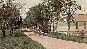
Main Street in 1907
|
|

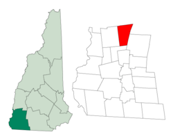
Location in Cheshire County, New Hampshire
|
|
| Country | United States |
| State | New Hampshire |
| County | Cheshire |
| Incorporated | 1761 |
| Communities |
|
| Area | |
| • Total | 26.4 sq mi (68.5 km2) |
| • Land | 26.0 sq mi (67.3 km2) |
| • Water | 0.5 sq mi (1.2 km2) 1.78% |
| Elevation | 1,161 ft (354 m) |
| Population
(2020)
|
|
| • Total | 749 |
| • Density | 29/sq mi (11.1/km2) |
| Time zone | UTC-5 (Eastern) |
| • Summer (DST) | UTC-4 (Eastern) |
| ZIP code |
03456
|
| Area code(s) | 603 |
| FIPS code | 33-45700 |
| GNIS feature ID | 0873660 |
Marlow is a small town in Cheshire County, New Hampshire, United States. In 2020, about 749 people lived here. Marlow is also home to the Honey Brook State Forest, a beautiful natural area.
Contents
History of Marlow
Early Beginnings: From Addison to Marlow
The town was first given a name in 1753. It was called "Addison" by the colonial Governor Benning Wentworth. He named it after Joseph Addison, a famous writer from England.
However, not many people settled in Addison because of the French and Indian War. So, on October 7, 1761, the land was given out again. This time, it went to William Noyes and 69 other people. Most of them came from Lyme, Connecticut.
The town was then renamed "Marlow." This new name came from a town in England called Marlow, England. That town is located on the River Thames.
Marlow's Industrial Past
Marlow's land shows many signs of being shaped by glacial action, which means huge ice sheets moved across it long ago. Even today, different minerals can be found here.
In the past, Marlow was known for its woodworking industry. People used the strong water power from the Ashuelot River to run their factories. They made tools, furniture, and wooden buckets from the trees cut nearby.
By 1859, when about 708 people lived in Marlow, the town had many businesses. There were seven sawmills, which cut wood, and a gristmill, which ground grain. There was also a shop that made carriages, a tin shop, and two tanneries that processed animal hides into leather. Even though the land was a bit rocky, farmers grew hay, grain, and vegetables.
Marlow was also the first home of a company called PC Connection. Today, this company is simply known as 'Connection'.
Geography of Marlow
Land and Water Features
Marlow covers a total area of about 68.5 square kilometers (26.4 square miles). Most of this area, about 67.3 square kilometers (26.0 square miles), is land. The rest, about 1.2 square kilometers (0.5 square miles), is water. This means water makes up about 1.78% of the town's total area.
The Ashuelot River flows through Marlow. This river is part of the larger Connecticut River watershed. A watershed is an area of land where all the water drains into a single river or lake.
The highest point in Marlow is at the top of Huntley Mountain. This mountain is in the northeastern part of the town. Its peak reaches about 1,978 feet (603 meters) above sea level.
Roads and Nearby Towns
Marlow is connected by several state roads. These include Route 10, Route 123, and a small part of Route 123A.
- Route 10 goes north to Newport and south to Keene.
- Route 123 goes east to Stoddard and west to Alstead.
- Route 123A goes northwest from Route 10 into the town of Acworth.
Towns Bordering Marlow
Marlow shares its borders with several other towns:
- To the north: Lempster
- To the northeast: Washington
- To the east: Stoddard
- To the south: Gilsum
- To the west: Alstead
- To the northwest: Acworth
Population Changes in Marlow
| Historical population | |||
|---|---|---|---|
| Census | Pop. | %± | |
| 1790 | 313 | — | |
| 1800 | 543 | 73.5% | |
| 1810 | 566 | 4.2% | |
| 1820 | 597 | 5.5% | |
| 1830 | 645 | 8.0% | |
| 1840 | 626 | −2.9% | |
| 1850 | 708 | 13.1% | |
| 1860 | 813 | 14.8% | |
| 1870 | 716 | −11.9% | |
| 1880 | 701 | −2.1% | |
| 1890 | 584 | −16.7% | |
| 1900 | 488 | −16.4% | |
| 1910 | 425 | −12.9% | |
| 1920 | 401 | −5.6% | |
| 1930 | 330 | −17.7% | |
| 1940 | 288 | −12.7% | |
| 1950 | 330 | 14.6% | |
| 1960 | 350 | 6.1% | |
| 1970 | 390 | 11.4% | |
| 1980 | 542 | 39.0% | |
| 1990 | 650 | 19.9% | |
| 2000 | 747 | 14.9% | |
| 2010 | 742 | −0.7% | |
| 2020 | 749 | 0.9% | |
| U.S. Decennial Census | |||
The population of Marlow has changed over many years. In 1790, there were 313 people. The population grew and then decreased at different times. By 2020, the town had 749 residents.
In 2000, there were 747 people living in Marlow. There were 292 households, and 221 of these were families. About 33.2% of households had children under 18 living with them. Most households (67.1%) were married couples living together.
The average household had about 2.56 people. The average family had about 2.89 people. The population was spread out across different age groups. About 24.9% of the people were under 18 years old. About 13.1% were 65 years or older. The average age in Marlow was 40 years.
Notable People from Marlow
- Osman Cleander Baker (1812–1871): He was a well-known biblical scholar and a bishop.
- Stephen Mack (1766–1826): He was a merchant, a patriot, and a politician. He was also the brother of Lucy Mack Smith and the uncle of Joseph Smith, who founded the Latter Day Saint movement.
See also
 In Spanish: Marlow (Nuevo Hampshire) para niños
 | William L. Dawson |
 | W. E. B. Du Bois |
 | Harry Belafonte |

