Lempster, New Hampshire facts for kids
Quick facts for kids
Lempster, New Hampshire
|
|
|---|---|

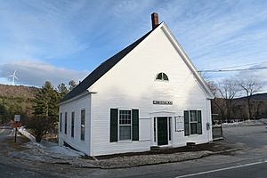
Lempster town offices
|
|

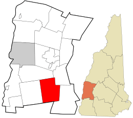
Location in Sullivan County and the state of New Hampshire.
|
|
| Country | United States |
| State | New Hampshire |
| County | Sullivan |
| Incorporated | 1772 |
| Named for | Sir Thomas Fermor, Second Baron Leominster or "Lempster" |
| Villages |
|
| Area | |
| • Total | 32.7 sq mi (84.8 km2) |
| • Land | 32.4 sq mi (83.8 km2) |
| • Water | 0.4 sq mi (1.0 km2) 1.22% |
| Elevation | 1,398 ft (426 m) |
| Population
(2020)
|
|
| • Total | 1,118 |
| • Density | 34/sq mi (13.3/km2) |
| Time zone | UTC-5 (Eastern) |
| • Summer (DST) | UTC-4 (Eastern) |
| ZIP code |
03605
|
| Area code(s) | 603 |
| FIPS code | 33-41700 |
| GNIS feature ID | 0873645 |
Lempster is a small town located in Sullivan County, New Hampshire, in the United States. In 2020, about 1,118 people lived there. The town has a main area called Lempster village and another smaller village called East Lempster.
Contents
History of Lempster
Lempster was first given out by a colonial governor named Jonathan Belcher in 1735. It was called "Number 9" because it was the ninth in a line of forts. These forts were built to protect against attacks from Native American tribes.
Later, in 1753, Governor Benning Wentworth gave the land out again. This time, it was named "Dupplin" after a Scottish lord, Thomas Hay, Viscount Dupplin.
Finally, in 1767, the town was given its current name, Lempster. It was named after Sir Thomas Fermor, who was the Second Baron of Leominster. The town officially became an incorporated town in 1772.
Geography of Lempster
Lempster covers a total area of about 84.8 square kilometers (32.7 square miles). Most of this area, about 83.8 square kilometers (32.4 square miles), is land. The rest, about 1.0 square kilometer (0.4 square miles), is water.
The highest point in Lempster is the top of Bean Mountain. This mountain is in the eastern part of town and is about 709 meters (2,326 feet) above sea level.
Rivers and Water Flow
All the water in Lempster flows into the Connecticut River. This means the town is part of the Connecticut River watershed.
- The northern part of town is drained by Giles Brook. This brook flows north into the South Branch of the Sugar River. The Sugar River then joins the Connecticut River in Claremont.
- The western side of town is drained by the Cold River and its smaller stream, Dodge Brook. These rivers flow into the Connecticut River in Walpole.
- The southeastern part of town is drained by the Ashuelot River. This river flows southwest and meets the Connecticut River in Hinsdale.
Roads and Villages
New Hampshire Route 10 is a main road that goes through Lempster. It connects the town to Goshen and Newport to the north. To the south, it connects to Marlow, Gilsum, and Keene.
The village of East Lempster is located where Route 10 meets the Second New Hampshire Turnpike. The main Lempster village is about 3 kilometers (2 miles) west along the Second New Hampshire Turnpike.
Glacial Boulders
Lempster is home to some very large boulders. Scientists believe these huge rocks were moved here by ancient glaciers. You can see examples of these boulders below:
Neighboring Towns
Lempster shares borders with these towns:
- Unity (to the north)
- Goshen (to the northeast)
- Washington (to the east)
- Marlow (to the south)
- Acworth (to the west)
Population of Lempster
| Historical population | |||
|---|---|---|---|
| Census | Pop. | %± | |
| 1790 | 415 | — | |
| 1800 | 729 | 75.7% | |
| 1810 | 854 | 17.1% | |
| 1820 | 950 | 11.2% | |
| 1830 | 999 | 5.2% | |
| 1840 | 941 | −5.8% | |
| 1850 | 906 | −3.7% | |
| 1860 | 820 | −9.5% | |
| 1870 | 678 | −17.3% | |
| 1880 | 602 | −11.2% | |
| 1890 | 519 | −13.8% | |
| 1900 | 391 | −24.7% | |
| 1910 | 383 | −2.0% | |
| 1920 | 287 | −25.1% | |
| 1930 | 273 | −4.9% | |
| 1940 | 312 | 14.3% | |
| 1950 | 309 | −1.0% | |
| 1960 | 272 | −12.0% | |
| 1970 | 360 | 32.4% | |
| 1980 | 637 | 76.9% | |
| 1990 | 947 | 48.7% | |
| 2000 | 971 | 2.5% | |
| 2010 | 1,154 | 18.8% | |
| 2020 | 1,118 | −3.1% | |
| U.S. Decennial Census | |||
According to the census from 2000, there were 971 people living in Lempster. By 2020, the population had grown to 1,118 residents. The average age of people in Lempster in 2000 was 41 years old.
Lempster Wind Farm
Lempster is special because it is home to New Hampshire's very first wind farm. A wind farm is a group of wind turbines that create electricity.
This wind farm has 12 large turbines. Together, they can produce 24 megawatts of power. The turbines started working in 2008. They are located on Bean Mountain, which is part of the Lempster Mountain ridge.
Notable People from Lempster
Some interesting people have come from Lempster:
- Martha Ann Honeywell (1786–1856), a talented artist.
- Martin L. Keyes (1850–?), who started the Keyes Fibre Company in 1903.
- Hosea Washington Parker (1833–1922), a lawyer and a congressman.
- Mary Elizabeth Perley (1863–?), an educator and author from the 19th and 20th centuries.
See also
 In Spanish: Lempster (Nuevo Hampshire) para niños
 | James Van Der Zee |
 | Alma Thomas |
 | Ellis Wilson |
 | Margaret Taylor-Burroughs |


