Goshen, New Hampshire facts for kids
Quick facts for kids
Goshen, New Hampshire
|
|
|---|---|

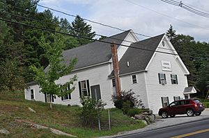
Town Hall
|
|

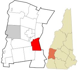
Location in Sullivan County and the state of New Hampshire
|
|
| Country | United States |
| State | New Hampshire |
| County | Sullivan |
| Incorporated | 1791 |
| Villages |
|
| Area | |
| • Total | 22.53 sq mi (58.36 km2) |
| • Land | 22.44 sq mi (58.12 km2) |
| • Water | 0.09 sq mi (0.24 km2) 0.41% |
| Elevation | 971 ft (296 m) |
| Population
(2020)
|
|
| • Total | 796 |
| • Density | 35/sq mi (13.7/km2) |
| Time zone | UTC-5 (Eastern) |
| • Summer (DST) | UTC-4 (Eastern) |
| ZIP code |
03752
|
| Area code(s) | 603 |
| FIPS code | 33-30500 |
| GNIS feature ID | 0873608 |
Goshen is a small town in Sullivan County, New Hampshire, United States. It's a quiet place with a population of 796 people, according to the 2020 census.
Contents
History of Goshen
Goshen was first settled in 1768. At that time, it was part of a larger area called Saville, which is now known as Sunapee.
The town officially became its own separate town, or "incorporated," in 1791. This means it got its own local government. The name "Goshen" might have come from Goshen, Connecticut. Many of the early settlers had relatives there.
Geography of Goshen
Goshen covers a total area of about 58.4 square kilometers (22.5 square miles). Most of this area is land, with only a small part being water.
The town has several small rivers and streams. These include the South Branch Sugar River, Blood Brook, and Gunnison Brook. Most of the water in Goshen eventually flows into the Connecticut River. A small part of the town's water flows into the Merrimack River.
The eastern edge of Goshen is home to a long hill called Mount Sunapee. The highest point in Goshen is on this ridge, reaching about 771 meters (2,529 feet) above sea level.
Two main roads pass through Goshen. New Hampshire Route 10 goes through the western part of town, including the main village area. It connects Goshen to Newport to the north and Keene to the south. New Hampshire Route 31 starts in Goshen and heads southeast towards Hillsborough.
Neighboring Towns
Goshen shares its borders with several other towns:
- Sunapee (to the north)
- Newbury (to the east)
- Bradford (to the southeast)
- Washington (to the south)
- Lempster (to the southwest)
- Unity (to the west)
- Newport (to the northwest)
Goshen's Population
| Historical population | |||
|---|---|---|---|
| Census | Pop. | %± | |
| 1800 | 383 | — | |
| 1810 | 563 | 47.0% | |
| 1820 | 687 | 22.0% | |
| 1830 | 772 | 12.4% | |
| 1840 | 779 | 0.9% | |
| 1850 | 659 | −15.4% | |
| 1860 | 576 | −12.6% | |
| 1870 | 507 | −12.0% | |
| 1880 | 511 | 0.8% | |
| 1890 | 384 | −24.9% | |
| 1900 | 345 | −10.2% | |
| 1910 | 329 | −4.6% | |
| 1920 | 283 | −14.0% | |
| 1930 | 255 | −9.9% | |
| 1940 | 352 | 38.0% | |
| 1950 | 356 | 1.1% | |
| 1960 | 351 | −1.4% | |
| 1970 | 395 | 12.5% | |
| 1980 | 549 | 39.0% | |
| 1990 | 742 | 35.2% | |
| 2000 | 741 | −0.1% | |
| 2010 | 810 | 9.3% | |
| 2020 | 796 | −1.7% | |
| U.S. Decennial Census | |||
Over the years, the number of people living in Goshen has changed. In 1800, there were 383 residents. The population grew to 810 in 2010, but then slightly decreased to 796 by 2020.
In 2000, about 24.2% of the people in Goshen were under 18 years old. About 13.6% were 65 years or older. The average age in town was 40 years.
Schools in Goshen
For many years, Goshen and the nearby town of Lempster shared an elementary and middle school called Goshen-Lempster Cooperative School. This school, located in Lempster, taught students from kindergarten through eighth grade.
However, this shared school system ended in June 2016. Now, most elementary and middle school students from Goshen attend schools in Newport, New Hampshire. The Newport school system helps educate Goshen's younger students.
After finishing eighth grade, students from Goshen have a choice of several high schools. These include Newport High School, Sunapee Middle-High School, and Kearsarge Regional High School.
Famous People from Goshen
- John Williams Gunnison (1812–1853) was a US Army officer. He was known for exploring the western parts of America.
See also
 In Spanish: Goshen (Nuevo Hampshire) para niños
 | May Edward Chinn |
 | Rebecca Cole |
 | Alexa Canady |
 | Dorothy Lavinia Brown |


