Hillsborough, New Hampshire facts for kids
Quick facts for kids
Hillsborough, New Hampshire
|
||
|---|---|---|
|
Town
|
||
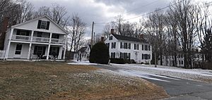
Houses in historic Hillsborough Center
|
||
|
||
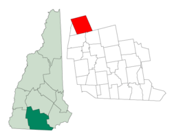
Location in Hillsborough County, New Hampshire
|
||
| Country | United States | |
| State | New Hampshire | |
| County | Hillsborough | |
| Incorporated | 1772 | |
| Villages |
|
|
| Area | ||
| • Total | 44.7 sq mi (115.8 km2) | |
| • Land | 43.7 sq mi (113.2 km2) | |
| • Water | 1.0 sq mi (2.6 km2) 2.24% | |
| Elevation | 636 ft (194 m) | |
| Population
(2020)
|
||
| • Total | 5,939 | |
| • Density | 136/sq mi (52.5/km2) | |
| Time zone | UTC-5 (Eastern) | |
| • Summer (DST) | UTC-4 (Eastern) | |
| ZIP code |
03244
|
|
| Area code(s) | 603 | |
| FIPS code | 33-36180 | |
| GNIS feature ID | 0873625 | |
Hillsborough, also known as Hillsboro, is a town in Hillsborough County, New Hampshire, United States. In 2020, about 5,939 people lived here. The town is home to Fox State Forest and part of Low State Forest, offering great outdoor spaces.
The main part of town, called the Hillsborough census-designated place (CDP), had 2,156 residents in 2020. It's located along the Contoocook River. Hillsborough also includes smaller villages like Hillsborough Center, Hillsborough Upper Village, Hillsborough Lower Village, and Emerald Lake Village.
Contents
Exploring Hillsborough's Past
Hillsborough was first given land in 1735. It was called "Number Seven" and was one of nine towns built to protect against attacks from Native American groups. This was decided by Jonathan Belcher, who was the governor of both Massachusetts and New Hampshire at the time.
In 1739, the border between Massachusetts and New Hampshire changed. This put Hillsborough fully in New Hampshire. In 1748, Governor Benning Wentworth officially named the town "Hillsborough." It was named after Sir Wills Hill, who was the Earl of Hillsborough. The town became an official town (incorporated) in 1772.
Birthplace of a President: Franklin Pierce
Hillsborough is famous for being the birthplace of Franklin Pierce. He was the 14th president of the United States. He is also the only president who came from New Hampshire.
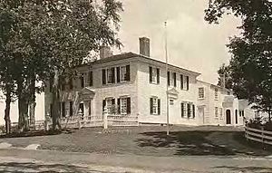
His father, Benjamin Pierce, built the Pierce Homestead in 1804. Benjamin Pierce was a general in the Revolutionary War and served as New Hampshire's governor twice. The home was fixed up in 1925 and became a special historic place in 1961. Today, it's a museum run by the Hillsborough Historical Society.
Historic Bridges and Railroads
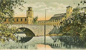
Hillsborough has a group of five stone arch bridges. These bridges were built in the 1800s. They are so important that they are recognized as a National Historic Civil Engineering Landmark.
Trains used to serve Hillsborough from 1878 to 1972. The railroad line connected Hillsborough to other towns. However, the tracks in Hillsborough were removed in 1979. A part of the old railroad line is now a rail trail, which is a path for walking and biking.
Understanding Hillsborough's Geography
Hillsborough covers a total area of about 115.8 square kilometers (44.7 square miles). Most of this area is land, about 113.2 square kilometers (43.7 square miles). The rest, about 2.6 square kilometers (1.0 square mile), is water.
Natural Features and Waterways
The highest point in Hillsborough is Thompson Hill. It stands at 1,768 feet (539 meters) above sea level. The town's water flows into the Contoocook River. Smaller streams like Beards Brook and Sand Brook also flow into it. A part of Franklin Pierce Lake is also in the town. All the water in Hillsborough eventually flows into the Merrimack River.
Neighboring Towns
Hillsborough shares its borders with several other towns:
- Bradford (to the north)
- Henniker (to the east)
- Deering (to the southeast)
- Antrim (to the south)
- Windsor (to the west)
- Washington (to the northwest)
Hillsborough's Population Over Time
| Historical population | |||
|---|---|---|---|
| Census | Pop. | %± | |
| 1790 | 798 | — | |
| 1800 | 1,311 | 64.3% | |
| 1810 | 1,592 | 21.4% | |
| 1820 | 1,982 | 24.5% | |
| 1830 | 1,792 | −9.6% | |
| 1840 | 1,808 | 0.9% | |
| 1850 | 1,685 | −6.8% | |
| 1860 | 1,623 | −3.7% | |
| 1870 | 1,595 | −1.7% | |
| 1880 | 1,646 | 3.2% | |
| 1890 | 2,120 | 28.8% | |
| 1900 | 2,254 | 6.3% | |
| 1910 | 2,168 | −3.8% | |
| 1920 | 2,229 | 2.8% | |
| 1930 | 2,160 | −3.1% | |
| 1940 | 2,269 | 5.0% | |
| 1950 | 2,179 | −4.0% | |
| 1960 | 2,310 | 6.0% | |
| 1970 | 2,775 | 20.1% | |
| 1980 | 3,437 | 23.9% | |
| 1990 | 4,498 | 30.9% | |
| 2000 | 4,928 | 9.6% | |
| 2010 | 6,011 | 22.0% | |
| 2020 | 5,939 | −1.2% | |
| U.S. Decennial Census | |||
In 2010, Hillsborough had 6,011 people living in 2,392 households. About 34% of households had children under 18. Most people in town were White (96.4%). Other groups included Black or African American (0.6%), Native American (0.3%), and Asian (0.6%). About 1.4% of the population was Hispanic or Latino.
The median age in town was 38.6 years. This means half the people were younger than 38.6, and half were older.
Learning in Hillsborough: Schools
Hillsborough is part of School Administrative Unit (SAU) 34. This means schools in the area work together. Public schools that serve the community of Hillsborough include:
- Hillsboro-Deering Elementary School
- Hillsboro-Deering Middle School
- Hillsboro-Deering High School
Places to Visit in Hillsborough
Hillsborough has several interesting places to see:
- Contoocook Mills Industrial District
- DAR Museum Room, located in the Fuller Public Library
- Five Stone Arch Bridges
- Franklin Pierce Homestead (built in 1804)
- Railroad Bridge (existed from 1903 to 1985)
- Union Chapel (built in 1887)
Famous People from Hillsborough
Many notable people have connections to Hillsborough:
- Christopher Columbus Andrews (1829–1922), a soldier, diplomat, and writer.
- Wilson Bethel (born 1984), an actor.
- Benjamin Pierce Cheney (1815–1895), one of the people who started American Express.
- Benjamin Pierce (1757–1839), who was the governor of New Hampshire and the father of President Franklin Pierce.
- Franklin Pierce (1804–1869), the 14th President of the United States.
- John Butler Smith (1838–1914), a manufacturer and the 44th governor of New Hampshire.
See also
 In Spanish: Hillsborough (Nuevo Hampshire) para niños
 | James B. Knighten |
 | Azellia White |
 | Willa Brown |


