
Five Stone Arch Bridges, Hillsborough, New Hampshire facts for kids

.jpg)
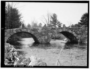
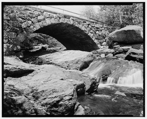

The Five Stone Arch Bridges are a special group of bridges in Hillsborough, New Hampshire, United States. These bridges are made of stone and have a curved, arch shape. They are so important that the American Society of Civil Engineers named them a National Historic Civil Engineering Landmark. This means they are recognized as amazing examples of engineering from the past.
Building Stone Arch Bridges
These strong stone arch bridges were built in the 1800s. Before this, most bridges were made of wood. Wooden bridges were not as strong and did not last as long. People needed sturdier bridges that could handle more weight and bad weather.
Building a stone arch bridge was a very difficult job. Stonecutters needed amazing skill. Each stone had to be shaped perfectly to fit with the others. If a stone was not just right, the whole arch could be weak. At one time, there were twelve stone arch bridges in Hillsborough. Today, only five remain.
Why These Bridges Are Special
The American Society of Civil Engineers (ASCE) recognized these five bridges in 2002. They were chosen as a National Historic Civil Engineering Landmark. A big reason for this honor is that they are all located close to each other. This makes them a unique collection of historic structures.
A man named Fred Rhyner helped make this happen. He is an engineer who works in Manchester, New Hampshire. Fred became interested in these bridges in 1996. He was working on a bridge project nearby. It took him three years to gather all the information. He filed the application in 1999.
Today, you can find a New Hampshire historical marker near the Sawyer Bridge. There is also an ASCE landmark plaque there. These markers tell visitors about the history and importance of these amazing stone bridges.
The Five Bridges
| Name | Location | Built Around | Crosses Over |
|---|---|---|---|
| Carr Bridge | 43°7′49″N 71°56′41″W / 43.13028°N 71.94472°W | mid-1800s | Beards Brook |
| Gleason Falls Bridge | 43°8′37″N 71°57′21″W / 43.14361°N 71.95583°W | ca. 1830 | Beards Brook |
| Gleason Falls Road over Beards Brook | 43°8′42″N 71°57′34″W / 43.14500°N 71.95944°W | mid-1800s | Beards Brook |
| Second New Hampshire Turnpike Bridge Bridge at Fuller's Tannery |
43°6′41″N 71°56′35″W / 43.11139°N 71.94306°W | ca. 1864 | North Branch River |
| Sawyer Bridge | 43°6′41″N 71°55′08″W / 43.11139°N 71.91889°W | ca. 1866 | Contoocook River |
