
Antrim, New Hampshire facts for kids
Quick facts for kids
Antrim, New Hampshire
|
||
|---|---|---|
|
Town
|
||

Antrim Town Hall
|
||
|
||

Location in Hillsborough County, New Hampshire
|
||
| Country | United States | |
| State | New Hampshire | |
| County | Hillsborough | |
| Incorporated | March 22, 1777 | |
| Villages |
|
|
| Area | ||
| • Total | 36.51 sq mi (94.57 km2) | |
| • Land | 35.70 sq mi (92.45 km2) | |
| • Water | 0.82 sq mi (2.12 km2) 2.24% | |
| Elevation | 712 ft (217 m) | |
| Population
(2020)
|
||
| • Total | 2,651 | |
| • Density | 74/sq mi (28.7/km2) | |
| Time zone | UTC-5 (Eastern) | |
| • Summer (DST) | UTC-4 (Eastern) | |
| ZIP codes |
03440 (Antrim)
03449 (Hancock) |
|
| Area code(s) | 603 | |
| FIPS code | 33-01700 | |
| GNIS feature ID | 0873533 | |

Antrim is a small town located in Hillsborough County, New Hampshire, in the United States. In 2020, about 2,651 people lived there. The main part of town, called the Antrim census-designated place (CDP), is where U.S. Route 202 and New Hampshire Route 31 meet. Antrim also includes smaller areas like Antrim Center, North Branch, and Clinton Village.
Contents
History of Antrim
Antrim was first settled in 1744. It officially became a town on March 22, 1777. The town got its name in 1778, named after County Antrim in Northern Ireland. This was the home of Philip Riley, who owned the land. In 1788, settlers from Scotland and Ireland started a Presbyterian church in Antrim.
Long ago, Great Brook had many mills along its banks. These mills used the power of the water to run their machines. The town's main business area grew in South Antrim, which is now the main village. Making knives and tools was a very important industry here. It started in 1864 with machines that peeled apples. The cutlery business continued until 1989. Today, many people who live in Antrim travel to work in nearby towns like Peterborough and Hillsborough. A former college campus in North Branch is now home to Hawthorne Academy.
Geography of Antrim
Antrim covers about 94.6 square kilometers (36.5 square miles) of land and water. Most of this area, about 92.4 square kilometers (35.7 square miles), is land. The rest, about 2.1 square kilometers (0.8 square miles), is water.
The Contoocook River and its North Branch flow through Antrim. Great Brook also helps drain the town. You can find Gregg Lake and Willard Pond in the western part of Antrim. Bald Mountain is the highest point in town, standing about 2,037 feet (621 meters) above sea level. It offers great views of Willard Pond. All the water in Antrim eventually flows into the Merrimack River.
The main town center, known as the Antrim CDP, covers about 4.5 square miles (12 square kilometers). This area includes the main village of Antrim, which used to be called South Antrim. It also includes parts of Clinton Village and Antrim Center.
Neighboring Towns
Antrim shares borders with these towns:
- Windsor (north)
- Hillsborough (northeast)
- Deering (east)
- Bennington (southeast)
- Hancock (south)
- Nelson (southwest)
- Stoddard (west)
Population of Antrim
| Historical population | |||
|---|---|---|---|
| Census | Pop. | %± | |
| 1790 | 528 | — | |
| 1800 | 1,059 | 100.6% | |
| 1810 | 1,277 | 20.6% | |
| 1820 | 1,330 | 4.2% | |
| 1830 | 1,309 | −1.6% | |
| 1840 | 1,225 | −6.4% | |
| 1850 | 1,143 | −6.7% | |
| 1860 | 1,123 | −1.7% | |
| 1870 | 904 | −19.5% | |
| 1880 | 817 | −9.6% | |
| 1890 | 1,248 | 52.8% | |
| 1900 | 1,366 | 9.5% | |
| 1910 | 1,235 | −9.6% | |
| 1920 | 1,052 | −14.8% | |
| 1930 | 1,254 | 19.2% | |
| 1940 | 1,127 | −10.1% | |
| 1950 | 1,030 | −8.6% | |
| 1960 | 1,121 | 8.8% | |
| 1970 | 2,122 | 89.3% | |
| 1980 | 2,208 | 4.1% | |
| 1990 | 2,360 | 6.9% | |
| 2000 | 2,449 | 3.8% | |
| 2010 | 2,637 | 7.7% | |
| 2020 | 2,651 | 0.5% | |
| U.S. Decennial Census | |||
In 2010, Antrim had 2,637 people living in 1,055 homes. Most people living in Antrim were white. About 23% of the population was under 18 years old. The average age of people in Antrim was about 43.5 years.
Education in Antrim
Antrim is part of a school district called SAU #1, also known as the Contoocook Valley Regional School District (ConVal). Students from Antrim attend these public schools:
- Elementary School: Antrim Elementary School, located in Antrim.
- Middle School: Great Brook School, located in Antrim.
- High School: ConVal Regional High School, located in Peterborough.
Festivals in Antrim
Every year in early fall, Antrim hosts the Antrim Home and Harvest festival. It's a fun event for the community.
Places to Visit in Antrim
- Antrim Historical Society & Museum
- James A Tuttle Library
- Avenue A
- The Antrim Grapevine
- The Antrim Grange
- Memorial Park
Notable People from Antrim
- Luther "Guitar Junior" Johnson (1939–2022), a musician.
- Steve Sawyer (1956–2019), an environmentalist and leader of Greenpeace.
Images for kids
-
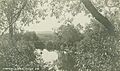
The Contoocook River around 1915
-
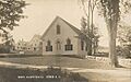
North Branch Chapel around 1915


See also
 In Spanish: Antrim (Nuevo Hampshire) para niños
