Antrim (CDP), New Hampshire facts for kids
Quick facts for kids
Antrim, New Hampshire
|
|
|---|---|

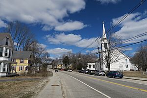
NH Route 31 northbound in Antrim
|
|
| Country | United States |
| State | New Hampshire |
| County | Hillsborough |
| Town | Antrim |
| Area | |
| • Total | 4.55 sq mi (11.79 km2) |
| • Land | 4.54 sq mi (11.77 km2) |
| • Water | 0.01 sq mi (0.02 km2) |
| Elevation | 709 ft (216 m) |
| Population
(2020)
|
|
| • Total | 1,395 |
| • Density | 306.93/sq mi (118.50/km2) |
| Time zone | UTC-5 (Eastern (EST)) |
| • Summer (DST) | UTC-4 (EDT) |
| ZIP code |
03440
|
| Area code(s) | 603 |
| FIPS code | 33-01620 |
| GNIS feature ID | 2378053 |
Antrim is a small community, also known as a census-designated place (CDP), located in Hillsborough County, New Hampshire, in the United States. It's the main village within the larger town of Antrim. In 2020, about 1,395 people lived in the Antrim CDP, while the whole town of Antrim had a population of 2,651.
Contents
Antrim's Location and Roads
Antrim CDP is found in the southeastern part of the town of Antrim. To the east, it's next to the Contoocook River, which also marks the border with the town of Bennington. To the south, it borders the towns of Bennington and Hancock.
On its western side, the CDP is bordered by Old Hancock Road and New Hampshire Route 31. To the north, you'll find Miltmore Road, Smith Road, and Cochran Brook. The main village of Antrim is in the southern part of the CDP. The western part also includes areas known as Antrim Center and Clinton Village.
Main Roads in Antrim
U.S. Route 202 is the most important road that goes through Antrim. It heads north about 7 miles (11 km) to Hillsborough and south about 12 miles (19 km) to Peterborough.
Another important road is New Hampshire Route 31. It starts in Antrim village and goes northwest through Clinton Village and Antrim Center. This route continues for about 26 miles (42 km) until it ends in Goshen.
Area and Water
The Antrim CDP covers a total area of about 4.55 square miles (11.8 square kilometers). Most of this area is land, with only a very small part, about 0.01 square miles (0.02 square kilometers), being water.
People Living in Antrim
The number of people living in Antrim has changed a bit over the years. Here's a quick look at the population counts from different census years:
| Historical population | |||
|---|---|---|---|
| Census | Pop. | %± | |
| 1980 | 1,142 | — | |
| 1990 | 1,325 | 16.0% | |
| 2000 | 1,389 | 4.8% | |
| 2010 | 1,397 | 0.6% | |
| 2020 | 1,395 | −0.1% | |
| U.S. Decennial Census | |||
Who Lives Here?
In 2010, there were 1,397 people living in the Antrim CDP. These people lived in 561 households, and 364 of these were families.
Most of the people living in Antrim CDP are white (97.1%). A small number of residents are African American, Native American, or Asian. About 1.4% of the population identified as Hispanic or Latino.
Households and Families
- About 35.5% of households in Antrim CDP had children under 18 living with them.
- Nearly half (48.0%) of the households were married couples living together.
- About 11.4% of households had a female head of household with no husband present.
- Around 28.2% of all households were made up of people living alone.
- About 12.3% of households had someone living alone who was 65 years old or older.
The average household had about 2.46 people, and the average family had about 2.99 people.
Age Groups
The people in Antrim CDP are spread across different age groups:
- 24.1% were under 18 years old.
- 8.0% were between 18 and 24 years old.
- 24.1% were between 25 and 44 years old.
- 29.9% were between 45 and 64 years old.
- 13.8% were 65 years old or older.
The average age of people in Antrim CDP was 41.4 years.
See also
 In Spanish: Antrim (condado de Hillsborough) para niños
 | Victor J. Glover |
 | Yvonne Cagle |
 | Jeanette Epps |
 | Bernard A. Harris Jr. |


