Bennington, New Hampshire facts for kids
Quick facts for kids
Bennington, New Hampshire
|
|
|---|---|
|
Town
|
|

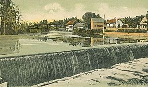
Great Falls, Contoocook River, c. 1905
|
|

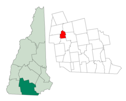
Location in Hillsborough County, New Hampshire
|
|
| Country | United States |
| State | New Hampshire |
| County | Hillsborough |
| Incorporated | 1842 |
| Area | |
| • Total | 11.6 sq mi (30.0 km2) |
| • Land | 11.4 sq mi (29.4 km2) |
| • Water | 0.2 sq mi (0.6 km2) 1.94% |
| Elevation | 659 ft (201 m) |
| Population
(2020)
|
|
| • Total | 1,501 |
| • Density | 132/sq mi (51.0/km2) |
| Time zone | UTC-5 (Eastern) |
| • Summer (DST) | UTC-4 (Eastern) |
| ZIP code |
03442
|
| Area code(s) | 603 |
| FIPS code | 33-04900 |
| GNIS feature ID | 0873543 |
Bennington is a small town in Hillsborough County, New Hampshire, United States. In 2020, about 1,501 people lived there.
The main part of Bennington is a village located by the Contoocook River. This area is where New Hampshire routes 31 and 47 meet.
Contents
History of Bennington
Bennington was once part of a larger area called "Society Land." It was created from pieces of nearby towns like Deering, Francestown, Greenfield, and Hancock.
How Bennington Got Its Name
The town was named to remember the Battle of Bennington in 1777. This important battle happened during the American Revolutionary War in New York. The battle itself was named after Bennington, Vermont. That Vermont town got its name from New Hampshire's governor, Benning Wentworth. Bennington, New Hampshire, officially became a town in 1842. In 1850, the first count of people showed 541 residents.
Early Industries and Mills
Bennington is located at the Great Falls of the Contoocook River. These falls drop about 70 feet (21 meters) over 1.2 miles (1.9 km). This powerful water was perfect for running mills. The first gristmill (for grinding grain) was built in 1782. A cotton mill followed in 1810.
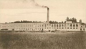
Later, industries like tanneries (for making leather) and tool manufacturing started up. A factory with paper-making machines opened in 1835. This factory was near where the Monadnock Paper Mill stands today. By 1858, Bennington had several businesses. These included a company making cutlery, a gristmill, two paper mills, and a sawmill. Many farms also operated in the town.
Geography of Bennington
Bennington covers a total area of about 11.6 square miles (30.0 square kilometers). Most of this area, about 11.4 square miles (29.4 square kilometers), is land. The rest, about 0.2 square miles (0.6 square kilometers), is water.
Rivers and Mountains
The Contoocook River flows north through Bennington. It forms Powder Mill Pond on the town's southern edge. The highest point in Bennington is on Crotched Mountain. This spot is about 2,020 feet (616 meters) above sea level. The very top of Crotched Mountain, which is 2,066 feet (630 meters) high, is just east of Bennington in Francestown. All the water in Bennington flows into the Merrimack River watershed.
Transportation in Bennington
Several important roads pass through Bennington. These include U. S. Route 202 and state routes 31 and 47.
Neighboring Towns
Bennington shares its borders with these towns:
- Antrim (north)
- Deering (northeast)
- Francestown (east)
- Greenfield (south)
- Hancock (west)
People in Bennington
In 2010, there were 1,476 people living in Bennington. There were 564 households, which are groups of people living together. About 386 of these were families.
Many households, about 35.8%, had children under 18 living with them. The average household had 2.62 people. The average family had 3.08 people.
The median age of people in town was 38.3 years old. About 25.7% of the population was under 18. About 8.9% were 65 years or older.
Economy of Bennington
Bennington is home to the Monadnock Paper Mills. This is a major paper manufacturing company. The town also has Crotched Mountain Ski & Ride. This is a medium-sized ski resort located near the Francestown border.
Education in Bennington
Bennington is part of SAU (School Administrative Unit) #1. This is also known as the Contoocook Valley Regional School District. It includes nine towns. Students from Bennington attend these schools:
- Elementary School: Pierce School, which is located right in Bennington.
- Middle School: Great Brook School, located in Antrim.
- High School: ConVal Regional High School, located in Peterborough.
See also
 In Spanish: Bennington (Nuevo Hampshire) para niños
 | Bessie Coleman |
 | Spann Watson |
 | Jill E. Brown |
 | Sherman W. White |


