
Stoddard, New Hampshire facts for kids
Quick facts for kids
Stoddard, New Hampshire
|
||
|---|---|---|
|
Town
|
||

Stone Arch Bridge
|
||
|
||

Location in Cheshire County, New Hampshire
|
||
| Country | United States | |
| State | New Hampshire | |
| County | Cheshire | |
| Incorporated | 1774 | |
| Villages |
|
|
| Area | ||
| • Total | 53.1 sq mi (137.4 km2) | |
| • Land | 50.9 sq mi (131.9 km2) | |
| • Water | 2.1 sq mi (5.5 km2) 3.99% | |
| Elevation | 1,427 ft (435 m) | |
| Population
(2020)
|
||
| • Total | 1,374 | |
| • Density | 27/sq mi (10.4/km2) | |
| Time zone | UTC-5 (Eastern) | |
| • Summer (DST) | UTC-4 (Eastern) | |
| ZIP codes |
03464 (Stoddard)
03457 (Nelson) |
|
| Area code(s) | 603 | |
| FIPS code | 33-73700 | |
| GNIS feature ID | 0873725 | |

Stoddard is a small town located in Cheshire County, New Hampshire, USA. In 2020, about 1,374 people lived there. This was more than the 1,232 people counted in 2010.
From 1842 to 1873, Stoddard was famous for making glass. Four glass factories operated here. The special glass they made, called Stoddard glass, is known for its beautiful deep amber colors. Collectors today really value these unique glass items.
Template:TOC limit=3
Contents
Stoddard's Past: A Look at Its History
The area now known as Stoddard was first given out in 1752. It was called "Monadnock Number 7." Colonel Sampson Stoddard, from Chelmsford, Massachusetts, and others received this land. People locally knew it as "Limerick" before it became an official town in 1774. It was named Stoddard to honor Colonel Stoddard.
Colonel Stoddard helped map out southwestern New Hampshire for the government. He received land for this work. One of his helpers was Benjamin Pierce, who was the father of U.S. President Franklin Pierce. Colonel Stoddard himself never lived in the town of Stoddard.
The first settlers arrived in 1768. They were John and Martha Taggart, who came from Derry, Ireland. Three years later, the Richardson family joined them. By 1774, the town had 24 residents.
The first official count of people in Stoddard was in 1790. It showed 701 residents. The town built its first schoolhouses in 1792. The first post office opened in 1822, with Isaac Duncan as the first Postmaster.
In 1800, Stoddard had 1,148 residents. This was more people than in nearby Keene, which is the county seat. During the time Stoddard made glass, about 800 people worked in the glass industry. After the glass industry ended in the early 1870s, the town's population went down. By 1960, only 146 people lived there. As of 2010[update], the town had 1,232 residents.
Stoddard Glass: A Unique Art
Between 1840 and 1873, Stoddard was a major place for making glass. Four glass factories here made products that collectors still love today. The town had many forests, which provided the wood needed to heat the furnaces. These furnaces had to reach 1,200 °F (650 °C) to melt sand into glass.
Stoddard also had lots of clear, fine sand. The tiny bits of minerals in the sand gave Stoddard glass its special colors. For example, manganese made the olive green and amber colors that Stoddard glass is known for. A small amount of gold oxide created a red-amber glass.
The glass factories were in two parts of Stoddard. Joseph Foster's and the South Stoddard Glass Company were in South Stoddard. This area was near where state Routes 9 and 123 are today. The Granite Glass Company and the New Granite Glass Works were in Mill Village, close to the current town center.
The glass factories made many different items. These included special Masonic flasks, bottles for drinks, and containers for patent medicines. They also made bottles for mineral water from Saratoga Springs, New York. However, Stoddard glass is most famous for the "off-blown" pieces. These were items made by glassblowers at the end of their workday. They used leftover glass to create these unique pieces, sometimes called "whimseys." The glassblower owned these special items.
Several things caused Stoddard's glass industry to end around the early 1870s. Other factories learned how to make clear glass in large amounts. Also, gas and coal became new fuels for glassworks. This meant factories no longer needed to be near forests. Better machines also made hand-blown glass too expensive to produce. The sand in Stoddard had silica, which made it hard to create clear glass. Clear glass became very popular for bottles and glassware after the Civil War.
Stoddard's Geography and Natural Features
According to the United States Census Bureau, Stoddard covers about 53.1 square miles (137.4 km2) of land and water. About 50.9 square miles (131.9 km2) is land, and 2.1 square miles (5.5 km2) is water. This means water makes up almost 4% of the town's total area.
The western part of Stoddard has streams that flow into the Ashuelot River. This river then goes into the Connecticut River. The middle and eastern parts of town drain into the North Branch of the Contoocook River. This river eventually flows into the Merrimack River.
Important lakes in Stoddard include Highland Lake and Island Pond in the northeast. Granite Lake is on the southern border.
The Monadnock-Sunapee Greenway is a hiking trail that goes through the western side of town. It passes near Center Pond. The trail continues towards Pitcher Mountain, which is the highest point in Stoddard. Pitcher Mountain is about 2,162 feet (659 m) above sea level.
New Hampshire Route 9 crosses the town from northeast to southwest. New Hampshire Route 123 also goes through the town center, from southeast to northwest.
Neighboring Towns
Stoddard shares its borders with several other towns:
- Washington (to the north)
- Windsor (to the northeast)
- Antrim (to the east)
- Nelson (to the south)
- Sullivan (to the southwest)
- Gilsum (to the west)
- Marlow (to the northwest)
Stoddard's Population Over Time
| Historical population | |||
|---|---|---|---|
| Census | Pop. | %± | |
| 1790 | 701 | — | |
| 1800 | 1,148 | 63.8% | |
| 1810 | 1,132 | −1.4% | |
| 1820 | 1,203 | 6.3% | |
| 1830 | 1,159 | −3.7% | |
| 1840 | 1,006 | −13.2% | |
| 1850 | 1,105 | 9.8% | |
| 1860 | 944 | −14.6% | |
| 1870 | 667 | −29.3% | |
| 1880 | 553 | −17.1% | |
| 1890 | 400 | −27.7% | |
| 1900 | 367 | −8.2% | |
| 1910 | 257 | −30.0% | |
| 1920 | 213 | −17.1% | |
| 1930 | 113 | −46.9% | |
| 1940 | 218 | 92.9% | |
| 1950 | 200 | −8.3% | |
| 1960 | 146 | −27.0% | |
| 1970 | 242 | 65.8% | |
| 1980 | 482 | 99.2% | |
| 1990 | 622 | 29.0% | |
| 2000 | 928 | 49.2% | |
| 2010 | 1,232 | 32.8% | |
| 2020 | 1,374 | 11.5% | |
| U.S. Decennial Census | |||
In 2000, Stoddard had 928 people living in 400 households. Most residents were White (96.88%). About 22.8% of households had children under 18. The average household had 2.32 people. The average family had 2.76 people.
The median age in town was 43 years old. About 20.2% of the population was under 18. About 15.1% were 65 years or older. For every 100 females, there were about 105 males.
The median income for a household was $37,639. For a family, it was $48,125. About 8.6% of the population lived below the poverty line. This included 10.3% of those under 18.
Education in Stoddard
Students from Stoddard who attend public high school and middle school go to schools in Keene. They attend Keene High School and Keene Middle School. Younger students in public elementary school go to James M. Faulkner Elementary School, which is located in Stoddard.
Images for kids
-
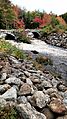
Stone Arch Bridge
-

Stoddard Town Seal
-
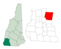
Location of Stoddard in Cheshire County, New Hampshire
See also
 In Spanish: Stoddard (Nuevo Hampshire) para niños
