Windsor, New Hampshire facts for kids
Quick facts for kids
Windsor, New Hampshire
|
|
|---|---|
|
Town
|
|

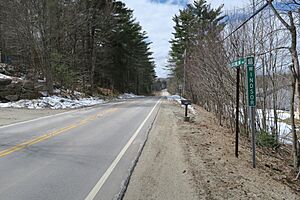
New Hampshire Route 31 westbound entering Windsor
|
|

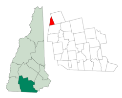
Location in Hillsborough County, New Hampshire
|
|
| Country | United States |
| State | New Hampshire |
| County | Hillsborough |
| Incorporated | 1798 |
| Area | |
| • Total | 8.5 sq mi (22.1 km2) |
| • Land | 8.3 sq mi (21.4 km2) |
| • Water | 0.3 sq mi (0.7 km2) 3.15% |
| Elevation | 974 ft (297 m) |
| Population
(2020)
|
|
| • Total | 262 |
| • Density | 32/sq mi (12.3/km2) |
| Time zone | UTC-5 (Eastern) |
| • Summer (DST) | UTC-4 (Eastern) |
| ZIP code |
03244
|
| Area code(s) | 603 |
| FIPS code | 33-85940 |
| GNIS feature ID | 0873759 |
Windsor is a small and quiet town located in Hillsborough County, New Hampshire, in the United States. In 2020, about 262 people lived there, making it a very small community.
Windsor is known for a few special places. It's home to the Wediko Children's Services Summer Program, which helps kids. It also hosts Windsor Mountain International, a summer adventure and travel camp that started in 1961. Plus, you can find the Windsor Hills Camp and Retreat Center, run by the Church of the Nazarene, in this town.
History of Windsor
Windsor officially became a town in 1768. It got its name from Windsor, Connecticut, which was the hometown of a person named John Campbell.
The land that became Windsor was originally leftover space from the areas around it in Hillsborough County. Before it was called Windsor, this land was known as "Campbell's Gore," named after John Campbell.
Geography and Nature
Windsor covers a total area of about 22.1 square kilometers (about 8.5 square miles). Most of this area is land, about 21.4 square kilometers (8.3 square miles). The rest, about 0.7 square kilometers (0.3 square miles), is water, like small ponds or streams.
The highest point in Windsor is the top of Windsor Mountain. It stands about 489 meters (1,604 feet) above sea level.
Nearby Towns
Windsor shares its borders with several other towns:
- To the northwest: Washington
- To the east: Hillsborough
- To the south: Antrim
- To the southwest: Stoddard
Population Changes
The number of people living in Windsor has changed a lot over the years. Here's a quick look at how the population has grown and shrunk:
| Historical population | |||
|---|---|---|---|
| Census | Pop. | %± | |
| 1790 | 120 | — | |
| 1800 | 249 | 107.5% | |
| 1810 | 238 | −4.4% | |
| 1820 | 237 | −0.4% | |
| 1830 | 226 | −4.6% | |
| 1840 | 177 | −21.7% | |
| 1850 | 172 | −2.8% | |
| 1860 | 136 | −20.9% | |
| 1870 | 81 | −40.4% | |
| 1880 | 420 | 418.5% | |
| 1890 | 62 | −85.2% | |
| 1900 | 38 | −38.7% | |
| 1910 | 24 | −36.8% | |
| 1920 | 21 | −12.5% | |
| 1930 | 22 | 4.8% | |
| 1940 | 29 | 31.8% | |
| 1950 | 27 | −6.9% | |
| 1960 | 35 | 29.6% | |
| 1970 | 43 | 22.9% | |
| 1980 | 72 | 67.4% | |
| 1990 | 107 | 48.6% | |
| 2000 | 201 | 87.9% | |
| 2010 | 224 | 11.4% | |
| 2020 | 262 | 17.0% | |
| U.S. Decennial Census | |||
In 2000, there were 201 people living in Windsor. The town had 58 households, and 37 of these were families. The average household had about 2.4 people.
About 33.8% of the population was under 18 years old. The median age in Windsor was 26 years old. This means half the people were younger than 26, and half were older.
See also
 In Spanish: Windsor (Nuevo Hampshire) para niños
 | Aaron Henry |
 | T. R. M. Howard |
 | Jesse Jackson |

