Unity, New Hampshire facts for kids
Quick facts for kids
Unity, New Hampshire
|
|
|---|---|

|
|

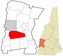
Location in Sullivan County and the state of New Hampshire.
|
|
| Country | United States |
| State | New Hampshire |
| County | Sullivan |
| Incorporated | 1764 |
| Villages | Unity East Unity Quaker City West Unity |
| Area | |
| • Total | 37.20 sq mi (96.34 km2) |
| • Land | 36.98 sq mi (95.78 km2) |
| • Water | 0.22 sq mi (0.56 km2) 0.58% |
| Elevation | 1,457 ft (444 m) |
| Population
(2020)
|
|
| • Total | 1,518 |
| • Density | 41/sq mi (15.8/km2) |
| Time zone | UTC-5 (Eastern) |
| • Summer (DST) | UTC-4 (Eastern) |
| ZIP Codes | |
| Area code(s) | 603 |
| FIPS code | 33-77940 |
| GNIS feature ID | 0873742 |
Unity is a small town located in Sullivan County, New Hampshire, in the United States. In 2020, about 1,518 people lived there. The town is made up of several smaller communities, including Unity, East Unity, Quaker City, and West Unity.
History of Unity
Before Europeans settled in America, the Connecticut River valley was home to the Abenaki people. They lived in large villages with special houses called longhouses.
The Abenaki people moved around depending on the season. They would fish, gather plants, make maple sugar, and trade with other groups. They also hunted and later started farming tobacco and important crops like corn, beans, and squash, known as the "three sisters."
Later, the area became part of the Province of New Hampshire, which was controlled by the British. In 1753, the land that is now Unity was given the name "Buckingham." However, there were disagreements over who owned the land because different governments had given out grants.
To solve these problems, the town was officially created and named "Unity" in 1764. This name showed that everyone had agreed and come together.
In 1790, the town had 538 residents. Unity was an important stop on the Second New Hampshire Turnpike, a trade route built in 1799. This road connected Amherst, New Hampshire, to Claremont. By 1810, Unity's population grew to 1,044 people. The town had several mills for grinding grain and cutting wood, a clothing mill, and a place to make alcohol. Raising Sheep was also a very important business.
Geography and Nature
Unity covers a total area of about 96.3 square kilometers (37.2 square miles). Most of this area, about 95.8 square kilometers (36.9 square miles), is land. The rest, about 0.6 square kilometers (0.2 square miles), is water.
All the water in Unity eventually flows into the Connecticut River. Rivers like the Little Sugar River and the Sugar River flow through the town. Crescent Lake, located on Unity's southern border, is where the Cold River begins.
The highest point in Unity is a hill along the town's northern edge. It stands about 613 meters (2,011 feet) above sea level.
Neighboring Towns
Unity shares its borders with several other towns:
- Newport (to the northeast)
- Goshen (to the east)
- Lempster (to the southeast)
- Acworth (to the southwest)
- Charlestown (to the west)
- Claremont (to the northwest)
Population in Unity
| Historical population | |||
|---|---|---|---|
| Census | Pop. | %± | |
| 1790 | 538 | — | |
| 1800 | 902 | 67.7% | |
| 1810 | 1,044 | 15.7% | |
| 1820 | 1,277 | 22.3% | |
| 1830 | 1,258 | −1.5% | |
| 1840 | 1,218 | −3.2% | |
| 1850 | 961 | −21.1% | |
| 1860 | 887 | −7.7% | |
| 1870 | 844 | −4.8% | |
| 1880 | 814 | −3.6% | |
| 1890 | 653 | −19.8% | |
| 1900 | 572 | −12.4% | |
| 1910 | 504 | −11.9% | |
| 1920 | 522 | 3.6% | |
| 1930 | 501 | −4.0% | |
| 1940 | 669 | 33.5% | |
| 1950 | 653 | −2.4% | |
| 1960 | 708 | 8.4% | |
| 1970 | 709 | 0.1% | |
| 1980 | 1,092 | 54.0% | |
| 1990 | 1,341 | 22.8% | |
| 2000 | 1,530 | 14.1% | |
| 2010 | 1,671 | 9.2% | |
| 2020 | 1,518 | −9.2% | |
| U.S. Decennial Census | |||
In the year 2000, there were 1,530 people living in Unity. There were 504 households, which are groups of people living together in one home. Most people in Unity were White.
About 30% of the households had children under 18 living with them. Most households were married couples living together. The average household had about 2.59 people.
The population of Unity is spread out across different age groups. In 2000, about 20% of the people were under 18 years old. About 20.6% were 65 years old or older. The average age in Unity was 43 years. For every 100 females, there were about 101.8 males.
See also
 In Spanish: Unity (Nuevo Hampshire) para niños
 | William Lucy |
 | Charles Hayes |
 | Cleveland Robinson |


