
Charlestown, New Hampshire facts for kids
Quick facts for kids
Charlestown, New Hampshire
|
||
|---|---|---|

|
||
|
||

Location in Sullivan County and the state of New Hampshire
|
||
| Country | United States | |
| State | New Hampshire | |
| County | Sullivan | |
| Incorporated | 1783 | |
| Villages |
|
|
| Area | ||
| • Total | 38.0 sq mi (98.5 km2) | |
| • Land | 35.8 sq mi (92.6 km2) | |
| • Water | 2.3 sq mi (5.9 km2) 5.98% | |
| Elevation | 384 ft (117 m) | |
| Population
(2020)
|
||
| • Total | 4,806 | |
| • Density | 134/sq mi (51.9/km2) | |
| Time zone | UTC-5 (Eastern) | |
| • Summer (DST) | UTC-4 (Eastern) | |
| ZIP code |
03603
|
|
| Area code(s) | 603 | |
| FIPS code | 33-11380 | |
| GNIS feature ID | 0873562 | |

Charlestown is a town in Sullivan County, New Hampshire, USA. In 2020, about 4,806 people lived there. It's home to the Hubbard State Forest and the main office of the Student Conservation Association, which helps young people protect nature.
The main village in town is also called Charlestown. About 1,078 people lived there in 2020. This village is located along New Hampshire Route 12. Other smaller villages in Charlestown include North Charlestown, South Charlestown, and Hemlock Center.
Contents
History of Charlestown
Early Settlement and Fort Number 4
The area where Charlestown is today was first given out on December 31, 1735. It was called "Plantation No. 4" by the governor of Massachusetts, Jonathan Belcher. This was the fourth town in a line of settlements along the Connecticut River.
People started settling here in 1740. It was the northernmost town at the time. In 1744, a strong wooden fort was built, known as Fort at Number 4. This fort became a very important military spot.
Battles and Bravery
In 1746, during a war called King George's War, a man named Seth Putnam was killed by Native Americans near the fort. He was the first person to die in an attack there.
In 1747, the fort was attacked for three days by French soldiers and Native Americans. Captain Phineas Stevens and 31 militia (local soldiers) bravely defended the fort. Their success became very famous.
Naming the Town
On July 2, 1753, the town was officially named "Charlestown" by Governor Benning Wentworth. It was named after Admiral Charles Knowles of the Royal Navy. Admiral Knowles was in Boston during the 1747 attack on the fort. He sent Captain Stevens a sword to honor his courage. The town then decided to name itself after him.
Captivity and Return
On August 30, 1754, Susannah Willard Johnson, her husband, their three children, her sister, and two neighbors were captured by Abenaki people. They were marched to Montreal and held in prison. Eventually, they all managed to escape or were set free and returned home.
Joining and Leaving Vermont
In 1781, Charlestown briefly joined the state of Vermont. This happened because the people were not happy with how the New Hampshire government was treating them. However, George Washington insisted they return to New Hampshire. So, in 1783, Charlestown officially became an incorporated town in New Hampshire.
Growth and Architecture
Charlestown grew into an important center for law and lawyers. It was second only to Boston in the region. This success led to many beautiful buildings being built.
Today, 63 buildings on Charlestown's Main Street are listed on the National Register of Historic Places. These include:
- The Gothic Revival South Parish Church, built in 1842.
- St. Luke's Church, designed in 1863.
- The Italianate Town Hall, designed in 1872 by Edward Dow. He was a very famous architect in New Hampshire after the Civil War.
In 1874, the Sullivan Railroad was built through the western part of Charlestown. These tracks are now part of the New England Central Railroad.
Fort at Number 4 Today
A copy of the original Fort at Number 4 is now a historical site. Here, you can often see military reenactments and gatherings during the summer. You can also take tours of the fort's walled area and pioneer-style houses.
-
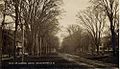
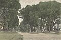
Main Street in 1909
-
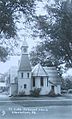
St. Luke's around 1920
-
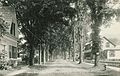
Summer Street in 1914
-
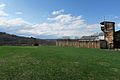
Fort at Number 4 in 2018
-
Main Street in 1910


Geography and Nature
Charlestown is located along the Connecticut River. This river forms the western border of New Hampshire.
The town covers a total area of about 98.5 square kilometers (38.0 square miles). Most of this is land (92.6 square kilometers or 35.8 square miles). About 5.9 square kilometers (2.3 square miles) is water, which is almost 6% of the town's total area.
Several small streams flow through Charlestown and into the Connecticut River. These include Ox Brook, the Little Sugar River, Beaver Brook, and Clay Brook. The highest point in town is Sams Hill, which is 1683 feet (513 meters) above sea level. It is located in the southeastern part of Charlestown.
In the 1800s, there were three islands in the Connecticut River within the town's limits. The largest, Sartwell's Island, was about 10 acres. The other two were about 6 acres each. These islands are not on maps today. They were likely covered by water when a power dam was built downstream at Bellows Falls.
Neighboring Towns
Charlestown shares borders with these towns:
- Claremont (north)
- Unity (northeast)
- Acworth (east)
- Langdon (south)
- Walpole (south)
- Rockingham, Vermont (southwest)
- Springfield, Vermont (west)
Getting Around Charlestown
Roads and Highways
Charlestown is served by several New Hampshire state routes:
- Route 11
- Route 12
- Route 12A
Routes 11 and 12 go north from the town center about 11 miles to downtown Claremont. Route 12 goes south about 7 miles to North Walpole, which is next to Bellows Falls, Vermont. It continues about 28 miles to Keene, New Hampshire. Route 11 goes northwest from Charlestown's center across the Connecticut River into Vermont. There, it becomes Vermont Route 11 and connects to Interstate 91 and U.S. Route 5.
Public Transportation
Bus service is available from Community Alliance Transport Services (CATS). Several buses run each day, connecting Charlestown and Claremont.
Rail and Air Travel
The New England Central Railroad has tracks running through Charlestown. Amtrak's Vermonter passenger train also runs through town along the Connecticut River. However, it does not stop in Charlestown. The closest train stations are Bellows Falls to the south and Claremont to the north.
For air travel, the closest small airports are:
- Claremont Municipal Airport, about 10 miles north.
- Hartness State Airport in North Springfield, Vermont, about 11 miles northwest.
The nearest airport with regular airline flights is Lebanon Municipal Airport. It is about 33 miles north in West Lebanon.
Notable People from Charlestown

- Helen Louisa Bostwick Bird (1826–1907), an author and poet.
- James Broderick (1927–1982), an actor and father of actor Matthew Broderick.
- William E. Corbin (1869–1951), who invented the paper towel.
- George Brintnall Dutton (1818-1898), a lawyer and politician in Minnesota.
- Carlton "Pudge" Fisk (born 1947), a famous baseball catcher in the Hall of Fame. He played for the Boston Red Sox and Chicago White Sox.
- Joseph Glidden (1813–1906), a businessman and farmer who invented modern barbed wire.
- Charles H. Hoyt (1859–1900), a playwright and theater producer.
- Henry Hubbard (1784–1857), a US congressman and senator, and the 18th governor of New Hampshire.
- Samuel Hunt (1765–1807), a US congressman.
- Susannah Willard Johnson (1729–1810), an Anglo-American woman who was captured by Native Americans and later returned home.
- Benjamin Labaree (1801–1883), a minister, professor, and college president.
- Ralph Metcalf (1796–1858), the 25th governor of New Hampshire.
- Simeon Olcott (1735–1815), a lawyer and US senator.
- DeForest Richards (1846–1903), a banker, farmer, and the fifth governor of Wyoming.
- Richard H. Sylvester (1830–1895), a journalist.
- James Tufts (1829–1884), who was acting governor of Montana Territory.
- Benjamin West (1746–1817), a lawyer.
- Francis H. West (1825–1896), a Union general during the Civil War.
- Alexander Hamilton Willard (1777–1865), a blacksmith who joined the famous Lewis and Clark Expedition.
Images for kids
-
Charlestown Town Seal
-

Location in Sullivan County and the state of New Hampshire
See also
 In Spanish: Charlestown (Nuevo Hampshire) para niños
