South Hooksett, New Hampshire facts for kids
Quick facts for kids
South Hooksett, New Hampshire
|
|
|---|---|

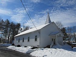
Grace Chapel Church of the Nazarene
|
|

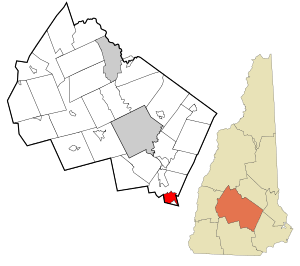
Location in Merrimack County and the state of New Hampshire
|
|
| Country | United States |
| State | New Hampshire |
| County | Merrimack |
| Town | Hooksett |
| Area | |
| • Total | 6.75 sq mi (17.48 km2) |
| • Land | 6.74 sq mi (17.46 km2) |
| • Water | 0.01 sq mi (0.02 km2) |
| Elevation | 443 ft (135 m) |
| Population
(2020)
|
|
| • Total | 5,888 |
| • Density | 873.59/sq mi (337.27/km2) |
| Time zone | UTC-5 (Eastern (EST)) |
| • Summer (DST) | UTC-4 (EDT) |
| Area code(s) | 603 |
| FIPS code | 33-71220 |
| GNIS feature ID | 0870038 |
South Hooksett is a special kind of community called a census-designated place (CDP). It's located within the town of Hooksett in Merrimack County, New Hampshire, United States. In 2020, about 5,888 people lived there. South Hooksett is a suburban area, meaning it's near a big city but has more homes and shops. It's right next to Manchester, which is New Hampshire's largest city. You'll find a mix of neighborhoods and large stores in South Hooksett.
Contents
Where is South Hooksett Located?
South Hooksett is in the southern part of the town of Hooksett. It's also in the very southern part of Merrimack County. To the west and south, it borders the city of Manchester. To the east, you'll find the town of Auburn. North of South Hooksett are roads like Legends Road and Hooksett Road (U.S. Route 3).
Part of the Southern New Hampshire University campus is also located within South Hooksett.
Land and Water Features
South Hooksett covers about 17.5 square kilometers (6.75 square miles) of land. Only a tiny bit, about 0.02 square kilometers (0.01 square miles), is water. The Merrimack River flows just outside the northwestern edge of the area. Smaller streams like Dalton Brook and Messer Brook flow through the northern part of South Hooksett and empty into the Merrimack River. The entire area is part of the Merrimack River's watershed, which means all the water eventually flows into this river.
Who Lives in South Hooksett?
| Historical population | |||
|---|---|---|---|
| Census | Pop. | %± | |
| 1960 | 1,407 | — | |
| 1970 | 1,662 | 18.1% | |
| 1980 | 1,584 | −4.7% | |
| 1990 | 1,717 | 8.4% | |
| 2000 | 3,638 | 111.9% | |
| 2010 | 5,418 | 48.9% | |
| 2020 | 5,888 | 8.7% | |
| U.S. Decennial Census | |||
In 2010, there were 5,418 people living in South Hooksett. They lived in 1,765 households, and 1,297 of these were families. The population density was about 1,020 people per square mile.
Most people in South Hooksett are White (94.4%). There are also smaller groups of African American (1.2%), Native American (0.3%), and Asian (2.0%) residents. About 2.0% of the population identified as Hispanic or Latino.
Households and Families
About 36.7% of the households in South Hooksett had children under 18 living with them. Most households (60.6%) were married couples living together. The average household had about 2.69 people, and the average family had about 3.07 people.
Age of Residents
The population in South Hooksett is spread out in terms of age. About 21.7% of the people were under 18 years old. About 17.6% were between 18 and 24, and 23.1% were between 25 and 44. People aged 45 to 64 made up 27.3% of the population, and 10.4% were 65 years or older. The average age was 36.2 years.
Income Levels
From 2009 to 2013, the average yearly income for a household in South Hooksett was estimated to be about $87,377. For families, the average income was even higher, around $105,769.
See also
 In Spanish: South Hooksett para niños
 | Sharif Bey |
 | Hale Woodruff |
 | Richmond Barthé |
 | Purvis Young |

