
Hudson, New Hampshire facts for kids
Quick facts for kids
Hudson, New Hampshire
|
||
|---|---|---|
|
Town
|
||
|
||

Location within Hillsborough County, New Hampshire
|
||
| Country | United States | |
| State | New Hampshire | |
| County | Hillsborough | |
| Incorporated | 1673 | |
| Annexed | 1731 | |
| Incorporated | 1746 (renamed in 1830) | |
| Villages |
|
|
| Area | ||
| • Total | 29.3 sq mi (75.8 km2) | |
| • Land | 28.3 sq mi (73.3 km2) | |
| • Water | 1.0 sq mi (2.5 km2) | |
| Elevation | 148 ft (45 m) | |
| Population
(2020)
|
||
| • Total | 25,394 | |
| • Density | 898/sq mi (346.7/km2) | |
| Time zone | UTC-5 (EST) | |
| • Summer (DST) | UTC-4 (EDT) | |
| ZIP code |
03051
|
|
| Area code(s) | 603 | |
| FIPS code | 33-37940 | |
| GNIS feature ID | 0873631 | |

Hudson is a town in Hillsborough County, New Hampshire, United States. It is located right along the Massachusetts state line. In 2020, about 25,394 people lived there, making it the tenth-largest town or city in New Hampshire by population.
The main part of Hudson, called the Hudson census-designated place (CDP), is home to about 7,534 people. It's located where three important roads (New Hampshire Routes 102, 111, and 3A) meet. This area is directly across the Merrimack River from the city of Nashua.
Contents
Hudson's History
Early Beginnings
Hudson started as part of a large land area called the Dunstable Land Grant. This grant included what is now Nashua, New Hampshire, and parts of towns like Dunstable and Pepperell, Massachusetts. In 1732, the part of Dunstable east of the Merrimack River became the town of Nottingham, Massachusetts.
Nine years later, the official border between Massachusetts and New Hampshire was set. The New Hampshire part of Nottingham was then renamed Nottingham West. This was done to avoid confusion with another town called Nottingham, New Hampshire, which was to the northeast.
Renaming the Town
In 1830, after many years, the town's name was changed again to "Hudson." This was to prevent confusion with the older town of Nottingham. People at the time thought the Merrimack River might have been connected to the Hudson River, or that explorer Henry Hudson had visited the area. Both of these ideas turned out to be untrue stories, but the name "Hudson" stuck!
The Hills Family Legacy
The Alfred and Virginia Hills family was very important in Hudson's history. They owned a large piece of land north of Hudson Village. Dr. Hills' family were some of the first people to settle in Hudson.
The Hills House on Derry Road is the family's old vacation home. It is now listed on the National Register of Historic Places and is home to the Hudson Historical Society. This place hosts fun events every year, like the "Old Home Days" fair, "Harvest Fest," and the "Bronco Belly Bustin' Chili Fiesta."
The Hills Memorial Library is another important building, also on the National Register. It's one of the oldest public libraries in New Hampshire.
Alvirne High School
Alvirne High School and the Alvirne Chapel were built on land donated by the Hills family. The name "Alvirne" is a mix of "Alfred" and "Virginia." For many years, people believed the Hills' only son had died during a football game, which was why the school didn't have a football team for a long time. However, this was just a rumor; Dr. and Mrs. Hills only had two daughters who passed away as babies.
When it was discovered there was no rule against it, Alvirne High School started its first junior varsity football team in 1994, and a varsity team in 1996. Today, Alvirne High has one of the biggest agricultural and vocational programs in the area. It's called the Wilbur H. Palmer Agricultural and Vocational School. Students here run businesses like a bank, a restaurant, a store, a day care, a dairy farm, and a forestry program.
Hudson's Geography
Hudson is located in the southeastern part of Hillsborough County, right on the border with Massachusetts. The town covers about 75.8 square kilometers (29.3 square miles). Most of this area, about 73.3 square kilometers (28.3 square miles), is land, and 2.5 square kilometers (1.0 square mile) is water.
The highest point in Hudson is Bush Hill, which is about 157 meters (515 feet) above sea level. Hudson is also part of the Merrimack River watershed, meaning all its water flows into the Merrimack River.
Town Centers
Hudson has two historic centers, though they have changed a lot with modern growth.
- Hudson Village: This area is similar to the Hudson census-designated place. It's on the western side of town, by the Merrimack River, where Routes 3A, 111, and 102 meet. Many of the original schools, libraries, and town government buildings were here. While some town services have moved, the Town Hall is still here. The historic Hills Memorial Library building is a landmark, even though the library's collection moved to the new Rodgers Memorial Library on Route 102. The Town Common, a park at the intersection of Derry, Ferry, and Library streets, is known for its large toy soldiers and decorations during Christmas.
- Hudson Center: This was the other historic town center. It's located where Central Street (Route 111), Greeley Street, Kimball Hill Road, and Windham Road meet. Two important landmarks here are no longer active. Benson's Wild Animal Farm, a former zoo and amusement park, closed in the late 1980s. The land was bought by the town and is now a park for walking and enjoying nature. A railway once passed through the Center, taking passengers to Benson's. Greeley Field, a popular park in Hudson Center, has a playground, Little League baseball field, and basketball courts. Nearby, you can find a Revolutionary War-era cemetery and an old school house.
Neighboring Towns
Hudson shares its borders with several other towns:
- Londonderry (north)
- Windham (northeast)
- Pelham (east)
- Tyngsborough, Massachusetts (south)
- Nashua (west)
- Litchfield (northwest)
Hudson's Climate
Hudson has a warm-summer humid continental climate. This means it has warm, humid summers and cold, snowy winters.
| Climate data for Hudson, New Hampshire, 1991–2020 normals, extremes 1985–present | |||||||||||||
|---|---|---|---|---|---|---|---|---|---|---|---|---|---|
| Month | Jan | Feb | Mar | Apr | May | Jun | Jul | Aug | Sep | Oct | Nov | Dec | Year |
| Record high °F (°C) | 70 (21) |
75 (24) |
86 (30) |
94 (34) |
95 (35) |
98 (37) |
102 (39) |
99 (37) |
95 (35) |
85 (29) |
79 (26) |
74 (23) |
102 (39) |
| Mean maximum °F (°C) | 55.3 (12.9) |
57.3 (14.1) |
67.1 (19.5) |
81.3 (27.4) |
88.8 (31.6) |
92.2 (33.4) |
94.0 (34.4) |
92.2 (33.4) |
88.8 (31.6) |
78.4 (25.8) |
69.2 (20.7) |
59.4 (15.2) |
95.6 (35.3) |
| Mean daily maximum °F (°C) | 33.5 (0.8) |
36.5 (2.5) |
44.7 (7.1) |
57.9 (14.4) |
68.9 (20.5) |
77.7 (25.4) |
83.4 (28.6) |
81.8 (27.7) |
74.2 (23.4) |
61.3 (16.3) |
49.3 (9.6) |
38.9 (3.8) |
59.0 (15.0) |
| Daily mean °F (°C) | 23.2 (−4.9) |
25.0 (−3.9) |
33.8 (1.0) |
46.0 (7.8) |
57.3 (14.1) |
66.7 (19.3) |
72.3 (22.4) |
70.5 (21.4) |
62.5 (16.9) |
49.7 (9.8) |
38.8 (3.8) |
29.3 (−1.5) |
47.9 (8.9) |
| Mean daily minimum °F (°C) | 12.9 (−10.6) |
13.5 (−10.3) |
22.9 (−5.1) |
34.1 (1.2) |
45.7 (7.6) |
55.6 (13.1) |
61.2 (16.2) |
59.1 (15.1) |
50.8 (10.4) |
38.0 (3.3) |
28.3 (−2.1) |
19.7 (−6.8) |
36.8 (2.7) |
| Mean minimum °F (°C) | −7.4 (−21.9) |
−4.6 (−20.3) |
3.5 (−15.8) |
21.0 (−6.1) |
30.3 (−0.9) |
41.0 (5.0) |
49.3 (9.6) |
46.5 (8.1) |
34.4 (1.3) |
23.6 (−4.7) |
13.4 (−10.3) |
1.2 (−17.1) |
−10.3 (−23.5) |
| Record low °F (°C) | −23 (−31) |
−18 (−28) |
−11 (−24) |
14 (−10) |
24 (−4) |
33 (1) |
43 (6) |
37 (3) |
26 (−3) |
15 (−9) |
−6 (−21) |
−13 (−25) |
−23 (−31) |
| Average precipitation inches (mm) | 3.31 (84) |
3.21 (82) |
4.22 (107) |
4.06 (103) |
3.64 (92) |
4.16 (106) |
3.32 (84) |
3.75 (95) |
3.68 (93) |
4.66 (118) |
3.70 (94) |
4.35 (110) |
46.06 (1,168) |
| Average snowfall inches (cm) | 17.1 (43) |
16.3 (41) |
14.6 (37) |
2.8 (7.1) |
0.0 (0.0) |
0.0 (0.0) |
0.0 (0.0) |
0.0 (0.0) |
0.0 (0.0) |
0.6 (1.5) |
2.0 (5.1) |
13.4 (34) |
66.8 (168.7) |
| Average precipitation days (≥ 0.01 in) | 11.8 | 10.7 | 12.2 | 12.2 | 13.1 | 11.9 | 11.0 | 10.5 | 9.5 | 11.2 | 11.2 | 12.0 | 137.3 |
| Average snowy days (≥ 0.1 in) | 7.7 | 7.9 | 6.1 | 1.4 | 0.0 | 0.0 | 0.0 | 0.0 | 0.0 | 0.2 | 1.3 | 5.8 | 30.4 |
| Source 1: NOAA | |||||||||||||
| Source 2: National Weather Service | |||||||||||||
People of Hudson
Population Growth Over Time
Hudson's population has grown a lot over the years. Here's how it has changed:
| Historical population | |||
|---|---|---|---|
| Census | Pop. | %± | |
| 1790 | 1,064 | — | |
| 1800 | 1,267 | 19.1% | |
| 1810 | 1,376 | 8.6% | |
| 1820 | 1,227 | −10.8% | |
| 1830 | 1,282 | 4.5% | |
| 1840 | 1,144 | −10.8% | |
| 1850 | 1,312 | 14.7% | |
| 1860 | 1,222 | −6.9% | |
| 1870 | 1,066 | −12.8% | |
| 1880 | 1,045 | −2.0% | |
| 1890 | 1,092 | 4.5% | |
| 1900 | 1,261 | 15.5% | |
| 1910 | 1,344 | 6.6% | |
| 1920 | 1,954 | 45.4% | |
| 1930 | 2,702 | 38.3% | |
| 1940 | 3,409 | 26.2% | |
| 1950 | 4,183 | 22.7% | |
| 1960 | 5,876 | 40.5% | |
| 1970 | 10,638 | 81.0% | |
| 1980 | 14,022 | 31.8% | |
| 1990 | 19,530 | 39.3% | |
| 2000 | 22,928 | 17.4% | |
| 2010 | 24,467 | 6.7% | |
| 2020 | 25,394 | 3.8% | |
| U.S. Decennial Census | |||
In 2010, there were 24,467 people living in Hudson. About 8,900 households and 6,683 families called Hudson home. The average household had about 2.73 people.
Age and Income
The population in Hudson is spread out across different age groups. About 24.9% of the people were under 18 years old. The median age (the middle age) in Hudson was 39.6 years.
For families in Hudson, the estimated average yearly income was about $93,199 between 2010 and 2012.
Education in Hudson

Hudson is part of School Administrative Unit #81 in New Hampshire. Here are the schools in town:
- High School (grades 9-12):
* Alvirne High School: This school also has the Wilbur H. Palmer Vocational-Technical Center, which offers business-focused training.
- Middle School (grades 6-8):
* Hudson Memorial School
- Elementary Schools (grades K-5):
* Dr. H. O. Smith School (grade 1) * Library Street School (kindergarten) * Hills-Garrison School (grades 2-5) * Nottingham West Elementary School (grades 2-5)
- Private School:
* Presentation of Mary Academy ("PMA"): This is a private Catholic school for students from Pre-K to 8th grade.
Hudson's Economy
Hudson is mainly a "bedroom community" for the Greater Boston area. This means many people who live in Hudson travel to Boston or nearby cities for work.
In 2006, there were about 10,945 jobs in Hudson. The town's biggest employers include Benchmark Electronics, BAE Systems, and the Hudson School District. Presstek also has its main office in Hudson.
Getting Around Hudson
Main Roads
Three main New Hampshire state routes go through Hudson:
- NH 3A: This road runs north-south through town. It enters from Massachusetts and follows several local roads before heading north towards Litchfield. Part of it shares the road with NH 102.
- NH 102: This route starts at a bridge over the Merrimack River from Nashua. It briefly joins NH 111 and then NH 3A along Derry Street before continuing northeast towards Londonderry.
- NH 111: This road enters from Nashua over the same bridge as NH 102. It goes east-west through town, following Ferry Street, Burnham Road, and Central Street, and then leaves towards Windham.
There's also a part of the unfinished Circumferential Highway in Hudson. This road helps connect Hudson to the Everett Turnpike in Nashua using the Sagamore Bridge.
Travel by Air and Rail
The closest airports are Boire Field in Nashua and Manchester–Boston Regional Airport near Londonderry and Manchester.
For train travel, the closest service is the Lowell Line of the MBTA Commuter Rail in Lowell, Massachusetts. The nearest Amtrak stations are in Boston. For bus travel, the closest station is in Nashua. Hudson itself does not have public transportation, though a street trolley used to run through town.
Fun Places to Visit in Hudson
Lakes and Ponds
Hudson has two small lakes for recreation:
- Robinson Pond: Located in the northern part of town, it has a public beach and a boat ramp. People enjoy fishing here in the summer and skating or playing ice hockey in the winter.
- Otternic Pond (also called "Tonic Pond"): This pond is between Hudson Center and Hudson Village. It has a public boat landing. Like Robinson Pond, it's popular for fishing in summer and ice activities in winter.
- Musquash Pond (or Swamp): In the southern part of town, this is a wild bird sanctuary. Many rare and endangered birds use it as a breeding ground. Years ago, hunters would travel far to camp and hunt in this swamp.
Benson Park
Benson's Wild Animal Farm was a zoo and amusement park that closed down. In May 2010, it reopened as Benson Park, a town park for everyone to enjoy. The park has trails for walking, biking, and hiking, along with ponds, picnic areas, a playground for kids, and dog parks. There's no fee to enter. A lot of work has been done to fix up the park's trails, gardens, and old buildings like the Old Lady in the Shoe, the gorilla house, and the elephant barn. The park also hosts "cage concerts" in the elephant barn. Benson Park is home to the largest 9/11 memorial in New Hampshire.
Libraries and Golf Courses
- Hills Memorial Library: Located in Hudson Village, this was one of the oldest public libraries in New Hampshire before it closed in 2009. It's listed on the National Register of Historic Places and remains an important landmark.
- Golf Courses: Hudson has two public golf courses: the Whip-Poor-Will Golf Club off Route 102 and the Green Meadow Golf Club on Steele Road (off Route 3A/Lowell Road).
Hudson Speedway
Near the northern edge of town, you'll find the Hudson Speedway. This is a 1/4-mile paved racetrack that hosts races from the NASCAR Advance Auto Parts Weekly Series.
Images for kids
-
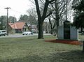
Hudson Town Common with Hills Memorial Library in the background.
-
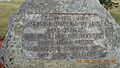
Revolutionary War monument to Samuel Greeley, for whom Greeley Street is named.

.jpg)
See also
 In Spanish: Hudson (Nuevo Hampshire) para niños
