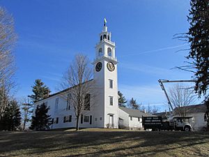
East Derry, New Hampshire facts for kids
Quick facts for kids
East Derry, New Hampshire
|
|
|---|---|

First Parish Congregational Church
|
|
| Country | United States |
| State | New Hampshire |
| County | Rockingham |
| Town | Derry |
| Elevation | 430 ft (130 m) |
| Time zone | UTC-5 (Eastern (EST)) |
| • Summer (DST) | UTC-4 (EDT) |
| ZIP code |
03041
|
| Area code(s) | 603 |
| GNIS feature ID | 866704 |
East Derry, also called the Upper Village, is a special community in the town of Derry. It is located in Rockingham County, New Hampshire, in the United States. This area is known as an unincorporated community, meaning it's part of a larger town but has its own unique identity.
The heart of the village is called the East Derry Historic District. This district is so important that it's listed on the National Register of Historic Places. You can find East Derry on a hill, about 2 miles (3.2 km) east of downtown Derry. It even has its own ZIP code (03041), different from the rest of Derry. Did you know that Alan Shepard, a famous astronaut, lived here when he was a boy? The Derry Fire Department also has one of its stations, Station #4, located in the village.
Contents
A Look Back in Time
Early Settlers and Founding
East Derry's story began in 1719. This area, known as Derry's Upper Village, was first settled by Scots-Irish Presbyterians. They came here to find a new home and escape difficulties in their homeland. This makes East Derry the oldest settlement in the town of Derry.
The area became part of Londonderry in 1722. Later, in 1827, it officially separated and became its own town, called Derry. The oldest building in the village is the First Church. It was built way back in 1769 and made bigger in 1824. Behind the church, there's a cemetery where many of the first settlers are buried.
Village Life and Growth
East Derry grew and thrived as a somewhat independent place in the 1800s. It had its own post office and shops. One of these old shops, built around 1850, is still standing today on East Derry Road.
The village was also important for education. It was home to Derry's very first secondary school. It was also where John Pinkerton lived. He was the person who helped start the Pinkerton Academy, a private school founded in 1814. This school still serves as the high school for Derry today. East Derry was also the location of the Adams Female Academy, which opened in 1824. This was the first academy for women in New Hampshire.
Historic Buildings and Famous Residents
The center of East Derry has many interesting old buildings. These include the Taylor Library and the old town hall, which was built in 1875. This old town hall is now owned by a historical society. You can also see many beautiful Federal-style houses from the early 1800s. As mentioned before, the childhood home of astronaut Alan Shepard is also located in this historic village.
 | Victor J. Glover |
 | Yvonne Cagle |
 | Jeanette Epps |
 | Bernard A. Harris Jr. |


