Derry (CDP), New Hampshire facts for kids
Quick facts for kids
Derry, New Hampshire
|
|
|---|---|

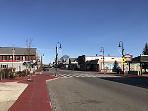
West/East Broadway
|
|
| Country | United States |
| State | New Hampshire |
| County | Rockingham |
| Town | Derry |
| Area | |
| • Total | 16.27 sq mi (42.14 km2) |
| • Land | 16.02 sq mi (41.50 km2) |
| • Water | 0.25 sq mi (0.64 km2) |
| Elevation | 280 ft (90 m) |
| Population
(2020)
|
|
| • Total | 22,879 |
| • Density | 1,427.80/sq mi (551.27/km2) |
| Time zone | UTC-5 (Eastern (EST)) |
| • Summer (DST) | UTC-4 (EDT) |
| ZIP codes |
03038 (Derry),
03041 (East Derry) |
| Area code(s) | 603 |
| FIPS code | 33-17860 |
| GNIS feature ID | 2378058 |
Derry is a special area in the town of Derry, located in Rockingham County, New Hampshire, United States. It's called a census-designated place (CDP). This means it's an area that the government tracks for population numbers.
The Derry CDP includes the main town center, the village of East Derry, and other nearby neighborhoods. In 2020, about 22,879 people lived in the CDP. The entire town of Derry had a population of 34,317 people.
Contents
Where is Derry Located?
The Derry CDP is in the middle part of the town of Derry. It stretches from the western edge to the eastern edge of the town. The main part of Derry is in the west, where two important roads, Route 102 and Route 28, meet. The village of East Derry is closer to the center of the CDP.
The western border of the CDP is next to the town of Londonderry. The eastern border touches the towns of Hampstead and Sandown. A small part of the northeast border is next to Chester.
Major Roads in Derry
Several important roads pass through Derry:
- Route 28 goes through the center of Derry. It leads northwest about 4 miles to Interstate 93 and 11 miles to Manchester. To the southeast, Route 28 goes about 10 miles to Salem.
- Route 102 crosses Route 28 in downtown Derry. It goes southwest about 1 mile to Interstate 93 and 12 miles to Nashua. To the northeast, Route 102 leads about 15 miles to Raymond.
- Route 28 Bypass is east of Derry's main area. It goes northwest about 8 miles to New Hampshire Route 101.
- Interstate 93 forms part of Derry's southwestern border. It leads northwest about 11 miles to Manchester and southeast about 40 miles to Boston, Massachusetts.
Land and Water
The Derry CDP covers about 16.27 square miles (42.1 square kilometers). Most of this area, about 16.02 square miles (41.5 square kilometers), is land. The rest, about 0.25 square miles (0.6 square kilometers), is water.
Beaver Lake is a notable body of water in the middle of the CDP. It's northeast of Derry village and northwest of East Derry. Water from Beaver Lake flows into Beaver Brook, which then flows southwest through Derry.
Who Lives in Derry?
The population of Derry has grown a lot over the years. Here's how many people have lived there during different census counts:
| Historical population | |||
|---|---|---|---|
| Census | Pop. | %± | |
| 1960 | 4,468 | — | |
| 1970 | 6,090 | 36.3% | |
| 1980 | 12,248 | 101.1% | |
| 1990 | 20,446 | 66.9% | |
| 2000 | 22,661 | 10.8% | |
| 2010 | 22,015 | −2.9% | |
| 2020 | 22,879 | 3.9% | |
| U.S. Decennial Census | |||
Derry's Population in 2010
In 2010, there were 22,015 people living in the Derry CDP. These people lived in 8,806 households. A household is a group of people living together in one home. About 5,704 of these households were families.
Most people in Derry were white (94.2%). There were also smaller groups of African American, Native American, and Asian people. About 3.6% of the population identified as Hispanic or Latino.
Families and Age Groups
- About 35.4% of households had children under 18 living with them.
- Many households (45.6%) were married couples living together.
- About 13.5% of households were led by a female without a husband present.
- Around 27.3% of all households were made up of people living alone.
- The average household had about 2.48 people.
- The average family had about 3.03 people.
The median age in Derry was 37.5 years old. This means half the people were younger than 37.5, and half were older.
- 23.6% of residents were under 18 years old.
- 9.8% were between 18 and 24 years old.
- 28.2% were between 25 and 44 years old.
- 28.9% were between 45 and 64 years old.
- 9.6% were 65 years old or older.
Income in Derry
From 2011 to 2015, the estimated average yearly income for a household in Derry was about $63,526. For families, the average income was higher, around $81,867.
The average income per person in the CDP was about $28,048. About 10.0% of the population and 7.3% of families lived below the poverty line. This included 16.7% of people under 18 and 7.1% of people 65 or older.
See also
 In Spanish: Derry (condado de Rockingham) para niños
 | Ernest Everett Just |
 | Mary Jackson |
 | Emmett Chappelle |
 | Marie Maynard Daly |


