Raymond, New Hampshire facts for kids
Quick facts for kids
Raymond, New Hampshire
|
||
|---|---|---|
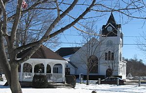
The Common (Lyman Memorial Park), 2013
|
||
|
||
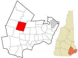
Location in Rockingham County and the state of New Hampshire.
|
||
| Country | United States | |
| State | New Hampshire | |
| County | Rockingham | |
| Incorporated | 1764 | |
| Area | ||
| • Total | 29.6 sq mi (76.7 km2) | |
| • Land | 28.8 sq mi (74.6 km2) | |
| • Water | 0.8 sq mi (2.1 km2) 2.68% | |
| Elevation | 200 ft (60 m) | |
| Population
(2020)
|
||
| • Total | 10,684 | |
| • Density | 371/sq mi (143.1/km2) | |
| Time zone | UTC-5 (Eastern) | |
| • Summer (DST) | UTC-4 (Eastern) | |
| ZIP code |
03077
|
|
| Area code(s) | 603 | |
| FIPS code | 33-64020 | |
| GNIS feature ID | 0873705 | |
Raymond is a town located in Rockingham County, New Hampshire, United States. In 2020, about 10,684 people lived here. A part of Pawtuckaway State Park can be found in the northern area of the town.
The main village in Raymond is also known as the Raymond census-designated place (CDP). This area is home to 3,738 people as of 2020. It is located along the Lamprey River, close to New Hampshire Route 27.
Contents
Discovering Raymond's Past: A Look at Its History
Raymond was first settled by families from Exeter. It was originally a part of Chester and was called Freetown. This name came about because the town was allowed to use its tall pine trees. These trees were usually reserved for making masts for the English Royal Navy.
How Raymond Got Its Name: Two Theories
The town was officially made a town in 1764 by Governor Benning Wentworth. There are two main ideas about how Raymond got its name.
Theory 1: A "Shining World"
One idea comes from a book written in 1875 by Joseph Fullonton. He said the name "Raymond" was chosen to be "new and classical." Fullonton explained that the original name, "Freetown," came from the timber business. Locals took trees that the king wanted, and because they were successful, they called the area Freetown. When it became an official town in 1764, the name changed to Raymond. Fullonton believed "Raymond" means "the lustrous, luminous or shining world."
Theory 2: Honoring Captain William Rayment
Another idea is that the town was named after Captain William Rayment (or Raymond). He was from Beverly, Massachusetts, and led soldiers in a war against Canada in 1690. In 1735, Captain Raymond and his soldiers were given land called Beverly-Canada as payment. This land is now Weare.
However, this land claim became invalid when New Hampshire separated from Massachusetts in 1741. So, in 1767, the families of these soldiers were given land in Maine instead. This land was first called Raymondtown Plantation. Today, it includes the towns of Raymond, Casco, and part of Naples.
Key Milestones in Raymond's Development
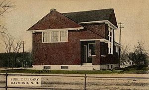
In 1906, Andrew Carnegie gave $2,000 to help build a library in Raymond. The Dudley-Tucker Library opened in 1908, overlooking the Common.
The Concord and Portsmouth Railroad line arrived in Raymond in 1861. This line connected Manchester to Portsmouth. It later became part of the Boston and Maine Railroad. Train service stopped in 1982. Now, the old railroad line is a trail for walking and biking. The old train station has been restored and is now home to the Raymond Historical Society.
Exploring Raymond's Landscape: Geography
Raymond covers a total area of about 29.6 square miles (76.7 square kilometers). Most of this area, about 28.8 square miles (74.6 square kilometers), is land. The remaining 0.8 square miles (2.1 square kilometers) is water, making up about 2.67% of the town.
The Lamprey River flows through Raymond. The highest point in town is Dumplingtown Hill. It stands about 625 feet (191 meters) above sea level. You can find it near the western border of the town.
Raymond's Central Village and Nearby Towns
The central village of Raymond, known as a census-designated place (CDP), has an area of about 4.8 square miles (12.4 square kilometers). Most of this is land, with a small part being water.
Several state routes pass through Raymond, including 27, 101, 102, and 107. Raymond shares its borders with several other towns:
- To the north: Deerfield and Nottingham
- To the east: Epping and Fremont
- To the south: Chester
- To the west: Candia
Who Lives in Raymond: Demographics
| Historical population | |||
|---|---|---|---|
| Census | Pop. | %± | |
| 1790 | 727 | — | |
| 1800 | 808 | 11.1% | |
| 1810 | 898 | 11.1% | |
| 1820 | 961 | 7.0% | |
| 1830 | 1,000 | 4.1% | |
| 1840 | 989 | −1.1% | |
| 1850 | 1,256 | 27.0% | |
| 1860 | 1,269 | 1.0% | |
| 1870 | 1,121 | −11.7% | |
| 1880 | 1,053 | −6.1% | |
| 1890 | 1,131 | 7.4% | |
| 1900 | 1,100 | −2.7% | |
| 1910 | 1,203 | 9.4% | |
| 1920 | 1,050 | −12.7% | |
| 1930 | 1,165 | 11.0% | |
| 1940 | 1,340 | 15.0% | |
| 1950 | 1,428 | 6.6% | |
| 1960 | 1,867 | 30.7% | |
| 1970 | 3,003 | 60.8% | |
| 1980 | 5,453 | 81.6% | |
| 1990 | 8,713 | 59.8% | |
| 2000 | 9,674 | 11.0% | |
| 2010 | 10,138 | 4.8% | |
| 2020 | 10,684 | 5.4% | |
| U.S. Decennial Census | |||
According to the census from 2010, Raymond had 10,138 people living in 3,925 households. About 2,796 of these were families. Most people in Raymond (97.0%) were white. A smaller number were African American (0.7%), Native American (0.2%), or Asian (0.6%). About 1.1% of the population identified as Hispanic or Latino.
Households and Families
About 32.3% of households had children under 18 living with them. More than half (55.7%) were married couples living together. The average household had 2.58 people, and the average family had 2.98 people.
Age and Income
In 2010, about 21.7% of Raymond's population was under 18 years old. About 9.5% were 65 years or older. The average age in town was 39.9 years.
From 2011 to 2015, the estimated average yearly income for a household was $64,490. For families, it was $77,345. About 6.9% of all people and 3.6% of families in Raymond lived below the poverty line.
Famous People from Raymond
Raymond has been home to some notable people:
- Chris Carpenter (born 1975): A former baseball pitcher for the St. Louis Cardinals. He grew up in Raymond.
- Frank J. Mafera (1898–1956): He invented residential chain link fencing.
See also
 In Spanish: Raymond (Nuevo Hampshire) para niños
 | Victor J. Glover |
 | Yvonne Cagle |
 | Jeanette Epps |
 | Bernard A. Harris Jr. |


