
Weare, New Hampshire facts for kids
Quick facts for kids
Weare, New Hampshire
|
|
|---|---|
|
Town
|
|

Town Hall
|
|
| Motto(s):
"A Part of Yesterday in Touch with Tomorrow"
|
|

Location in Hillsborough County, New Hampshire
|
|
| Country | United States |
| State | New Hampshire |
| County | Hillsborough |
| Incorporated | 1764 |
| Named for | Meshech Weare |
| Villages |
|
| Area | |
| • Total | 60.1 sq mi (155.7 km2) |
| • Land | 59.1 sq mi (153.0 km2) |
| • Water | 1.0 sq mi (2.7 km2) 1.72% |
| Elevation | 633 ft (193 m) |
| Population
(2020)
|
|
| • Total | 9,092 |
| • Density | 154/sq mi (59.4/km2) |
| Time zone | UTC-5 (Eastern) |
| • Summer (DST) | UTC-4 (Eastern) |
| ZIP code |
03281
|
| Area code(s) | 603 |
| FIPS code | 33-79780 |
| GNIS feature ID | 0873749 |
Weare is a town located in Hillsborough County, New Hampshire, United States. In 2020, about 9,092 people lived there. Weare is close to two important New Hampshire cities: Manchester and Concord.
Contents
Weare's Early History

Weare was first given to soldiers who fought in the Canadian wars in 1735. The governor at the time, Jonathan Belcher, named it "Beverly-Canada." This name came from their hometown, Beverly, Massachusetts.
However, this first grant was not valid. Later, in 1749, a new grant gave about 6 square miles to Ichabod Robie. This area was known by names like "Hale's Town" or "Robie's Town."
How Weare Got Its Name
In 1764, Governor Benning Wentworth officially made it a town and named it Weare. It was named after Meshech Weare. He was the town's first clerk and later became New Hampshire's first governor.
Clinton Grove Academy
In 1834, Moses Cartland started Clinton Grove Academy. This was the first Quaker school for higher education in New Hampshire. Cartland was a cousin of the famous poet John Greenleaf Whittier.
He named the village "Clinton Grove" to honor DeWitt Clinton. Clinton was a main supporter of the Erie Canal. The academy first served as a private high school. Its buildings, including classrooms and a boarding house, burned down in 1872.
Classes then moved to the Quaker meetinghouse nearby. A new building was finished in 1874. This building was used by the Weare school district from 1877 to 1938.
The Great Flood of 1938
On September 21, 1938, a big hurricane hit New England. Heavy rains from the storm caused the Deering Reservoir dam to break. A huge wall of water rushed down towards the Weare Reservoir dam.
The Weare dam held, but the water broke through the land next to it. Millions of gallons of water from the reservoir were released. This flash flood destroyed everything in its path. Many active mills in Weare were washed away.
Building the Everett Dam
After the flood, the U.S. Army Corps of Engineers built the Everett Dam. This dam is about 2,000 feet long. It was part of a bigger project to stop floods like the one in 1938.
The project was finished in 1963 and cost $21.4 million. Because of the dam, the village of East Weare had to be left empty forever. The dam also created Everett Lake.
Weare's Geography
Weare covers about 155.7 square kilometers (about 60.1 square miles). Most of this area, 153.0 square kilometers, is land. The rest, 2.7 square kilometers, is water.
The Piscataquog River flows through Weare. This river forms Lake Horace in the northwest and Everett Lake in the northeast. All the water in Weare eventually flows into the Merrimack River.
Weare's Highest Points
The three highest points in Weare are close to the town's center.
- Mount Dearborn is about 1,211 feet (369 meters) above sea level.
- Mine Hill is also about 1,211 feet (369 meters) high.
- Mount Wallingford is about 1,210 feet (369 meters) high.
Roads in Weare
Several main roads cross through Weare. These include New Hampshire Route 77, New Hampshire Route 114, and New Hampshire Route 149.
Neighboring Towns
Weare shares borders with several other towns:
- Henniker (to the north)
- Hopkinton (to the north)
- Dunbarton (to the east)
- Goffstown (to the southeast)
- New Boston (to the south)
- Francestown (to the southwest)
- Deering (to the west)
Weare's Population Over Time
| Historical population | |||
|---|---|---|---|
| Census | Pop. | %± | |
| 1790 | 1,924 | — | |
| 1800 | 2,517 | 30.8% | |
| 1810 | 2,634 | 4.6% | |
| 1820 | 2,781 | 5.6% | |
| 1830 | 2,430 | −12.6% | |
| 1840 | 2,375 | −2.3% | |
| 1850 | 2,435 | 2.5% | |
| 1860 | 2,310 | −5.1% | |
| 1870 | 2,092 | −9.4% | |
| 1880 | 1,829 | −12.6% | |
| 1890 | 1,550 | −15.3% | |
| 1900 | 1,553 | 0.2% | |
| 1910 | 1,325 | −14.7% | |
| 1920 | 1,173 | −11.5% | |
| 1930 | 1,287 | 9.7% | |
| 1940 | 1,367 | 6.2% | |
| 1950 | 1,345 | −1.6% | |
| 1960 | 1,420 | 5.6% | |
| 1970 | 1,851 | 30.4% | |
| 1980 | 3,232 | 74.6% | |
| 1990 | 6,193 | 91.6% | |
| 2000 | 7,776 | 25.6% | |
| 2010 | 8,785 | 13.0% | |
| 2020 | 9,092 | 3.5% | |
| U.S. Decennial Census | |||
In 2000, there were 7,776 people living in Weare. There were 2,618 households, with 2,117 being families. About 48.2% of households had children under 18. Most households (71.0%) were married couples.
The average household had 2.97 people. The average family had 3.28 people. About 32.0% of the population was under 18. The median age was 34 years old.
The median income for a household was $59,924. For a family, it was $62,661. About 2.5% of the population lived below the poverty line.
Education in Weare
Weare has schools for different age groups.
- Center Woods Elementary School teaches children from pre-kindergarten to third grade. It is located on Center Road.
- Weare Middle School serves students from fourth to eighth grade. This school is on East Road in the center of Weare.
- High school students from Weare and Henniker attend John Stark Regional High School.
Famous People from Weare
- Elma Gove (1832–1921) was a painter.
- Gene Robinson (born 1947) was a bishop. He was the first openly gay priest to become a bishop in a major Christian church.
- David Souter (born 1939) was a former associate justice on the U.S. Supreme Court.
Images for kids
-
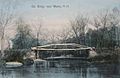
Old bridge c. 1905
-
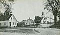
Baptist Church c. 1910
-
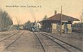
Boston & Maine Railroad station in 1910
-
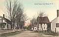
East Weare c. 1910


See also
 In Spanish: Weare (Nuevo Hampshire) para niños
