Raymond (CDP), New Hampshire facts for kids
Quick facts for kids
Raymond, New Hampshire
|
|
|---|---|

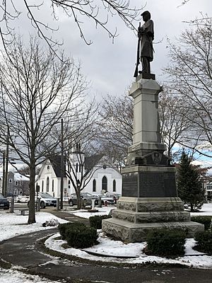
American Civil War monument in center of Raymond
|
|
| Country | United States |
| State | New Hampshire |
| County | Rockingham |
| Town | Raymond |
| Area | |
| • Total | 6.64 sq mi (17.19 km2) |
| • Land | 6.48 sq mi (16.78 km2) |
| • Water | 0.16 sq mi (0.42 km2) |
| Elevation | 205 ft (62 m) |
| Population
(2020)
|
|
| • Total | 3,738 |
| • Density | 577.03/sq mi (222.78/km2) |
| Time zone | UTC-5 (Eastern (EST)) |
| • Summer (DST) | UTC-4 (EDT) |
| ZIP code |
03077
|
| Area code(s) | 603 |
| FIPS code | 33-63940 |
| GNIS feature ID | 2378090 |
Raymond is a special area in the state of New Hampshire, United States. It's called a "census-designated place" (CDP), which means it's a specific area that the government counts people in, even if it's not a city or town itself. Raymond is the main village within the larger town of Raymond in Rockingham County.
In 2020, about 3,738 people lived in the Raymond CDP. This is part of the total 10,684 people who live in the entire town of Raymond.
Exploring Raymond's Geography
The Raymond CDP is located in the eastern part of the larger town of Raymond. It sits on both sides of the Lamprey River.
Borders and Natural Features
The eastern edge of the CDP touches the town lines of Epping and Fremont. To the north, its border follows roads like Ham Road and Harriman Hill Road. It also goes past the southern end of Governors Lake. The western border follows the Lamprey River and a small brook.
Major Roads and Travel
Several important roads pass through Raymond, making it easy to travel to other places.
Highways in Raymond
- New Hampshire Route 101 is a major freeway that goes through the southern part of Raymond. You can get on or off it at Exits 4 and 5.
- Route 101 goes east about 12 miles to Exeter.
- It also goes west about 16 miles to Manchester, a larger city.
Other Important Routes
- New Hampshire Route 27 used to be part of Route 101. It runs through the northern part of Raymond.
- Route 27 goes east about 5 miles to Epping and west about 7 miles to Candia.
- New Hampshire Route 102 starts in Raymond and goes southwest about 14 miles to Derry.
- New Hampshire Route 156 starts in Raymond and goes north about 6 miles to Nottingham.
- New Hampshire Route 107 follows parts of Routes 27 and 102 in Raymond. It leads northwest about 10 miles to Deerfield and southeast the same distance to Kingston.
Land and Water Area
The Raymond CDP covers a total area of about 6.64 square miles (17.2 square kilometers). Most of this area, about 6.48 square miles (16.8 square kilometers), is land. The rest, about 0.16 square miles (0.4 square kilometers), is water, like rivers and lakes.
People and Population in Raymond
The United States Census Bureau collects information about people living in different areas. Here's how Raymond's population has changed over the years:
| Historical population | |||
|---|---|---|---|
| Census | Pop. | %± | |
| 1980 | 1,192 | — | |
| 1990 | 2,516 | 111.1% | |
| 2000 | 2,839 | 12.8% | |
| 2010 | 2,855 | 0.6% | |
| 2020 | 3,738 | 30.9% | |
| U.S. Decennial Census | |||
Population Details from 2010
In 2010, there were 2,855 people living in the Raymond CDP. There were 1,192 households, which are groups of people living together in one home.
Diversity in Raymond
Most people in Raymond (about 96.9%) were white. Smaller groups included African American (0.7%), Native American (0.2%), and Asian (0.5%). About 1.6% of the people were of Hispanic or Latino background.
Households and Families
- About 29.5% of homes had children under 18 living there.
- Nearly half (47.7%) of homes were headed by married couples.
- About 12.0% had a female head of household with no husband present.
- The average household had 2.40 people, and the average family had 2.85 people.
Age Groups
- About 20.9% of residents were under 18 years old.
- About 28.6% were between 25 and 44 years old.
- About 13.0% were 65 years or older.
- The average age of people in Raymond was about 39.5 years.
Income Information (2011-2015)
From 2011 to 2015, the estimated average yearly income for a household in Raymond was about $60,313. For families, the average income was about $76,610. The average income per person was $28,216.
About 13.0% of the population and 5.6% of families lived below the poverty line. This included 11.1% of people under 18 and 13.4% of people 65 or older.
See also
 In Spanish: Raymond (condado de Rockingham) para niños
 | Jewel Prestage |
 | Ella Baker |
 | Fannie Lou Hamer |


