Epping (CDP), New Hampshire facts for kids
Quick facts for kids
Epping, New Hampshire
|
|
|---|---|

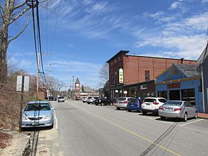
Main Street
|
|
| Country | United States |
| State | New Hampshire |
| County | Rockingham |
| Town | Epping |
| Area | |
| • Total | 4.34 sq mi (11.23 km2) |
| • Land | 4.30 sq mi (11.14 km2) |
| • Water | 0.04 sq mi (0.09 km2) |
| Elevation | 129 ft (39 m) |
| Population
(2020)
|
|
| • Total | 2,693 |
| • Density | 626.13/sq mi (241.77/km2) |
| Time zone | UTC-5 (Eastern (EST)) |
| • Summer (DST) | UTC-4 (EDT) |
| ZIP code |
03042
|
| Area code(s) | 603 |
| FIPS code | 33-24580 |
| GNIS feature ID | 2378062 |
Epping is a small community in New Hampshire, United States. It's like the main village within the larger town of Epping. Epping is located in Rockingham County. In 2020, about 2,693 people lived in this part of Epping. The whole town of Epping had a population of 7,125 people.
Contents
Where is Epping Located?
Epping is found in the south-central part of the town of Epping. It includes most of the main village and some less developed areas. The community is bordered by New Hampshire Route 101 to the south. The Lamprey River forms part of its western and northern borders.
Major Roads and Travel
Several important roads pass through Epping.
- New Hampshire Route 101 is an expressway. It goes east about 12 miles (19 km) to Interstate 95 in Hampton. To the west, it goes about 19 miles (31 km) to Interstate 93 in Manchester.
- New Hampshire Route 125 crosses Route 101. It leads north about 21 miles (34 km) to Rochester. South, it goes about 20 miles (32 km) to Haverhill, Massachusetts.
- New Hampshire Route 27 was the old route for Route 101. It goes east about 7 miles (11 km) to Exeter. West, it goes about 6 miles (10 km) to Raymond.
Land and Water Features
The Epping community covers about 4.3 square miles (11.2 square kilometers). Most of this area is land. Only a small part, about 0.04 square miles (0.1 square kilometers), is water. The Lamprey River flows through Epping village. It then continues east towards Great Bay.
Who Lives in Epping?
The number of people living in Epping has changed over the years.
| Historical population | |||
|---|---|---|---|
| Census | Pop. | %± | |
| 1970 | 1,097 | — | |
| 1980 | 1,384 | 26.2% | |
| 1990 | 1,384 | 0.0% | |
| 2000 | 1,673 | 20.9% | |
| 2010 | 1,681 | 0.5% | |
| 2020 | 2,693 | 60.2% | |
| U.S. Decennial Census | |||
Population Details
In 2010, there were 1,681 people living in Epping. They lived in 766 households. Most people were white, making up about 96.7% of the population. A small number of people were of other races, including Asian, Black, or Native American. About 1.2% of the population was Hispanic or Latino.
About 24.3% of households had children under 18 living there. Many households were married couples living together. Some households had a female head with no husband present. About 33.7% of households were single individuals.
The average age of people in Epping in 2010 was 43.4 years old. About 18.2% of residents were under 18. About 18.1% were 65 years or older.
Income Information
From 2011 to 2015, the average yearly income for a household in Epping was about $50,438. For families, the average income was around $57,083. The average income per person was about $27,359. A small number of people and families lived below the poverty line.
See also
 In Spanish: Epping (condado de Rockingham) para niños
 | Lonnie Johnson |
 | Granville Woods |
 | Lewis Howard Latimer |
 | James West |


