
Ipswich, Massachusetts facts for kids
Quick facts for kids
Ipswich, Massachusetts
|
||
|---|---|---|
| Town of Ipswich | ||

John Whipple House, constructed c. 1677
|
||
|
||
| Nickname(s):
Birthplace of American Independence
|
||

Location in Essex County and the state of Massachusetts.
|
||
| Country | United States | |
| State | Massachusetts | |
| County | Essex | |
| Settled | 1633 | |
| Incorporated | August 5, 1634 | |
| Founded by | John Winthrop the Younger | |
| Named for | Ipswich, England | |
| Government | ||
| • Type | Open town meeting | |
| Area | ||
| • Total | 42.5 sq mi (110.1 km2) | |
| • Land | 32.1 sq mi (83.2 km2) | |
| • Water | 10.4 sq mi (26.9 km2) | |
| Elevation | 50 ft (15 m) | |
| Population
(2020)
|
||
| • Total | 13,785 | |
| • Density | 324.28/sq mi (125.20/km2) | |
| Time zone | UTC−5 (Eastern) | |
| • Summer (DST) | UTC−4 (Eastern) | |
| ZIP Code |
01938
|
|
| Area code(s) | 351/356/978 | |
| FIPS code | 25-32310 | |
| GNIS feature ID | 0619448 | |

Ipswich is a town located on the coast in Essex County, Massachusetts, United States. In 2020, about 13,785 people lived there.
Ipswich is home to Willowdale State Forest and Sandy Point State Reservation. It also includes the southern part of Plum Island. It's a residential town known for its busy tourism industry. Ipswich is famous for its delicious clams, which are celebrated every year at the Ipswich Chowderfest. Another popular spot is Crane Beach, a sandy barrier beach near the beautiful Crane estate. Ipswich officially became a town in 1634.
Contents
History of Ipswich
Ipswich was started by John Winthrop the Younger in 1633. His father, John Winthrop, was one of the founders and the first governor of the Massachusetts Bay Colony. In 1630, hundreds of colonists sailed from England to America. They met a native chief named Chief Masconomet, who ruled the land known as Wonnesquamsauke, which the English called "Agawam."
The first winter was very hard for the colonists. Many got sick or didn't have enough food. A supply ship arrived just in time, saving them. In 1633, John Winthrop the Younger decided to settle in Agawam. Captain John Smith had described the area in 1614 as "an excellent habitation, being a good and safe harbour."
John the Younger and 12 other men sailed into Ipswich harbor and made it their home. On August 5, 1634, Agawam was officially named Ipswich. It was named after Ipswich in Suffolk, England. This was to show thanks for the help given to the colonists who sailed from there.
In 1638, Chief Masconomet sold the land of Ipswich to John Winthrop the Younger. There are no records of Native people fighting against the English settlers in this area. However, there were terrible diseases among the native people around 1617 and 1633. These diseases caused many native villages to become ghost towns.
The early settlers became farmers, fishermen, shipbuilders, or traders. The Ipswich River helped power mills, and the salt marshes provided hay for farm animals.
Birthplace of American Independence
In 1687, people in Ipswich, led by Reverend John Wise, protested a new tax. This tax was put in place by Governor Sir Edmund Andros. The people argued that it was wrong to be taxed without having a say in the government. This idea is called "no taxation without representation."
Some citizens were put in jail for protesting. But then Governor Andros was sent back to England in 1689. The new British rulers, William III and Mary II, gave the colonists a new charter. Because of this protest, Ipswich calls itself the "Birthplace of American Independence."
Ipswich Industries and Growth
A special kind of lace-making started in Ipswich. Ipswich Lace is a unique style. It is the only hand-made bobbin lace that was sold commercially in the U.S.
In the 1800s, large clipper ships used deeper harbors in other towns. So, Ipswich remained mostly a fishing and farming community. Many of its older homes were kept because people couldn't afford to build new ones. This means Ipswich still has many old and beautiful buildings.
In 1822, a machine for making stockings was brought to Ipswich from England. This was against British law. Because of this, Ipswich grew into a mill town. In 1828, the Ipswich Female Seminary was founded. Later, in 1868, the Ipswich Hosiery Mills opened by the river. By the early 1900s, it was the biggest stocking mill in the country.
In 1878, a strange event happened in Ipswich. It might have been the last "witchcraft trial" in North America. A person who followed the Christian Science religion was accused of using their mind to harm others.
The Crane Estate
In 1910, Richard T. Crane Jr., a rich businessman from Chicago, bought Castle Hill. This is a large hill on Ipswich Bay. He hired famous landscape designers to create beautiful gardens on his 3,500-acre estate. He also built a large Italian-style house on top of the hill.
His wife, Florence, didn't like the house. So, in 1928, a new 59-room mansion was built in its place. This grand house was called the Great House. When Mrs. Crane passed away in 1949, the entire property was given to The Trustees of Reservations. Today, it is used for concerts and weddings.
Town Government Changes
The way Ipswich is governed changed in 1950. The town adopted a Town Manager Charter. This charter was changed a few times. In 1967, voters chose the current Town Manager-Selectmen Charter. In 2012, Robin Crosbie became the first female Town Manager of Ipswich. She retired in 2018.
Geography of Ipswich
Ipswich is located in the middle of Essex County. The Ipswich River flows through the town and into Plum Island Sound. These waters then flow into Ipswich Bay and the Atlantic Ocean. The Crane estate has a long lawn that looks out over the bay. This is where "Castle Hill concerts" are often held.
The southern part of Plum Island is also part of Ipswich. This forms the town's ocean shore, along with Castle Neck. Much of the western part of town is covered by Willowdale State Forest. Many other areas in Ipswich are protected lands. These include Crane Wildlife Refuge on Castle Neck and parts of Appleton Farms Sanctuary.
Ipswich is about 11 miles south of Newburyport. It is also about 13 miles north of Salem and 28 miles northeast of Boston. Ipswich shares borders with Rowley to the north and Boxford to the west. It also borders Topsfield, Hamilton, Essex, and Gloucester to the south.
Transportation in Ipswich
There is no major interstate highway that goes directly through Ipswich. However, U.S. Route 1 (the Newburyport Turnpike) passes through the western part of town. Massachusetts Route 1A and Route 133 also go through Ipswich.
Ipswich has a train station on the Newburyport/Rockport Line. This train service connects Ipswich to Newburyport and Boston's North Station. There are no airports in Ipswich. The closest small airports are in Newbury and Beverly. For national flights, the nearest airport is Logan International Airport in Boston. During the summer, the Ipswich Essex Explorer shuttle service connects the Ipswich train station to places like Crane Beach and Appleton Farms.
Population of Ipswich
In 2020, the total population of Ipswich was 13,785 people.
Education in Ipswich
The first school in Ipswich, the Ipswich Grammar School, started around 1636.
Elementary Schools
Ipswich has two elementary schools: Paul F. Doyon Memorial and Winthrop. Paul F. Doyon is on Linebrook Road. It was renamed in 1967 after Paul F. Doyon, who died in the Vietnam War. Students attend these schools until fifth grade. After fifth grade, they move on to Ipswich Middle School.
Middle and High Schools
Ipswich Middle School (IMS) and Ipswich High School (IHS) are in the same building. They share a library, cafeteria, performing arts facilities, and sports areas. These include tennis courts, a baseball field, a football field, and a running track.
Ipswich Middle School teaches grades 6 through 8. Each grade has its own "pod," which is a common area with classrooms branching off it.
Ipswich High School is known as one of the best public high schools in the Boston area. The Ipswich Public Schools also have a very good performing arts program. In 2005, the high school received a "Blue Ribbon" award. This award recognizes national excellence in education. The school also received a Vanguard award for its strong academics. IHS offers different levels of classes, including college-prep, honors, and AP (Advanced Placement) classes. It has one of the highest graduation rates in Massachusetts.
The middle and high school music program is considered one of the best in the state. It offers dance, different choruses, various bands (like jazz and concert bands), and orchestras.
The high school's mascot is the Tiger, and the school colors are orange and black. Ipswich teams compete in the Cape Ann League. The high school football team won the Division 3A Super Bowl Championship in 2006. This was their first title since 1992, and their fifth overall. Ipswich's main sports rival is Hamilton-Wenham Regional High School. The Ipswich Volleyball Team has won the Division IV State Championship in 2021, 2022, and 2023.
Points of Interest in Ipswich
- Appleton Farms (started in 1638)
- Brown Stocking Mill Historic District
- Castle Hill (built in 1928)
- Choate Bridge (built in 1764)
- Crane Beach
- John Heard House/Ipswich Historical Society (c. 1800)
- John Whipple House (1642/1677)
- South Green Historic District
Notable People from Ipswich
- James Appleton, 19th century politician and activist
- Dick Berggren, motorsports announcer and magazine editor
- Charles E. Bohlen, U.S. diplomat
- Anne Bradstreet, poet
- Simon Bradstreet, governor
- Michael Burns, actor, historian, professor
- Rufus Choate, lawyer and politician
- Eunice Caldwell Cowles, educator
- Nathan Dane, lawyer
- Arthur Wesley Dow, artist
- John F. Dolan, legislator and conservation advocate
- Thomas Dudley, governor
- Dennis Eckersley, baseball Hall-of-Fame pitcher
- Ed Emberley, artist of children's drawing books
- Joseph English, also Joseph Quanophkonatt, Native American scout
- Melissa Ferrick, musician
- David Giddings, Wisconsin politician and businessman
- Sarah Whipple Goodhue, 17th-century writer
- Mark Harris, Maine politician
- Elizabeth Topham Kennan, former president of Mount Holyoke College
- Stuffy McInnis, baseball player and manager
- Jimmy McLane, swimmer, Olympic champion
- John Norton, author, minister
- John Proctor, victim of the Salem witch trials
- Richard S. Rust, abolitionist and educator
- Jenny Slew, one of the first black Americans to win her freedom in court
- Eric Standley, contemporary artist
- John Updike, author
- Nathaniel Ward, clergyman and jurist
Images for kids
-
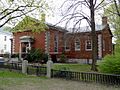
Ipswich Public Library
-
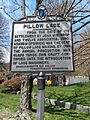
Ipswich Lace Historical Marker
-
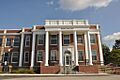
Town hall
-
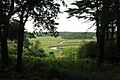
A view from Castle Hill
-
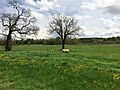
Appleton Farms Livestock
-
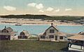
Little Neck c. 1920
-
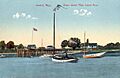
Grape Island c. 1910


See also
 In Spanish: Ipswich (Massachusetts) para niños
