
Ipswich River facts for kids
Quick facts for kids Ipswich River |
|
|---|---|

|
|
| Country | United States |
| Physical characteristics | |
| Main source | Burlington, Massachusetts 42°33′14″N 71°08′38″W / 42.5539828°N 71.1439441°W |
| River mouth | Ipswich Bay, Massachusetts 42°41′38″N 70°47′23″W / 42.6939825°N 70.7897712°W |
| Length | 35 mi (56 km) |
| Basin features | |
| Basin size | 155 sq mi (400 km2) |
| Tributaries |
|
The Ipswich River is a small river in northeastern Massachusetts, United States. It was very important for early settlers moving inland from the coast. The river offered a safe place for boats near Plum Island Sound. This helped early farmers and fishermen.
Parts of the river form borders between towns. It also separates Essex County (near the coast) from Middlesex County (more inland). The river is about 35 miles (56 km) long. Its watershed, the area of land that drains into it, is about 155 square miles (400 km²). About 160,000 people live in this area.
Long ago, the first settlement in Essex County was a small seaport called Agawam, which is now Ipswich. People often settled westward and northward along the Ipswich River.
Contents
Where the River Flows
The Ipswich River starts in Burlington, in northcentral Middlesex County. It flows southeast through several towns.
The river forms borders between:
- North Reading and Lynnfield
- Middleton and Peabody
- Middleton and Danvers
- Boxford and Topsfield
In colonial times, the wide swamps along the river made it hard to cross. The main route north from Boston was the Andover Road. This road crossed the river where Lubbers and Maple Meadow brooks join it.
River History and Use
The first written record about the Ipswich River is from 1638. John Winthrop bought land along the river from Chief Masconomet and the Agawam tribe. He also bought the exclusive right to fish there for 20 pounds sterling.
Most of the land along the river is privately owned. However, some areas are open for fun activities. You can use non-motorized boats, go fishing, and swim in certain spots. The river is popular with canoeists and people who enjoy watching birds. In the swampy and wetland areas, you can see many different birds and small animals.
The Ipswich River provides drinking water for many communities. It is estimated that about 350,000 people get their public drinking water from the river's watershed. Most of these people live outside the immediate river area. There are some worries about the water quality. Sometimes, the river dries up in certain places, and sadly, some areas become dumping grounds for trash like old tires.
River's Journey to the Sea
.jpg)
The river begins in Burlington. It then flows through Wilmington, where the Middlesex Canal once crossed over it. Next, it goes through Reading and North Reading.
In North Reading, the Skug River joins it. The Skug River starts in North Andover and Andover. It drains a large Beaver Pond and marshland. It also collects water from Harold Parker State Forest. Another small stream, Boston Brook, also flows into the Ipswich River.
Both the Skug River and Boston Brook join the Ipswich River in Middleton. The river then flows south into Peabody. After that, it loops north through Danvers and Topsfield. It crosses under US Route 1 near the Topsfield Fairground.
The river then flows through Willowdale State Forest and Bradley Palmer State Park. It forms the western border of the Julia Bird Reservation. Finally, it winds through Ipswich neighborhoods and the town center. It passes under MA 133.
After passing Nichols Field, the river widens as it enters the salt marsh floodplain. From there, it travels about 2.5 miles (4 km) to join Plum Island Sound. This sound connects to the Atlantic Ocean at Ipswich Bay.
The lower Ipswich River and Plum Island Sound are tidal estuaries. This means they mix with ocean saltwater during high tides. The land along the banks is often wet with this salty water. Only plants that can handle salt, like salt marsh hay, grow here. High tides cover the Great Marsh and the river's floodplains. Low tides reveal mud flats, turning the deep channels into small streams.

Small boats can travel upstream almost to Ipswich town center. However, there are rocky areas with a sharper drop in elevation further upstream. This makes it impossible to go further without carrying light boats over land.
The river and the land around it are currently facing a problem. There is less water flowing in the river. This is because a lot of water is taken from the ground in urban areas upstream for drinking water. The upper part of the river can even become completely dry in the summer.
To help protect wildlife, wetland areas have been created along much of the lower river. The water level in these areas is kept from falling too much by the Willowdale Mill Dam. This dam is a leftover from a mill system from the 1800s. Today, it is privately owned by a company that rents canoes.
The Ipswich River and Plum Island Sound flow out through a narrow, shallow channel. This channel passes under Castle Hill and along Crane's Beach. In the past, sailing ships faced dangers like Bar Head and Emerson Rocks when trying to enter or leave the estuary. Shallow waters often trapped vessels during storms, leading to shipwrecks.
Despite these difficulties, the sound and the mouth of the Ipswich River were once important places for ocean-going cargo ships, fishing boats, and whaling boats to dock. The quiet shores of the region today give little hint of how important it once was for trade and wealth.
Images for kids
-
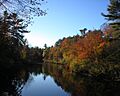
The Ipswich River from a footbridge in Bradley Palmer State Park, October 2007
-
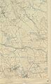
This 1893 USGS topographical map shows the middle regions of the Ipswich River draining left to right, alongside which are the more noticeable railways of yesteryear.
-
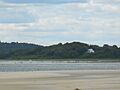
Mouth of the Ipswich River in Ipswich Bay, July 2010
