
Middlesex Canal facts for kids
Quick facts for kids |
|
|
Middlesex Canal
|
|

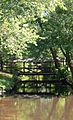
Remnants of the aqueduct that carried the canal over the Shawsheen River on the Billerica-Wilmington town line
|
|
| Lua error in Module:Location_map at line 420: attempt to index field 'wikibase' (a nil value). | |
| Location | Lowell-Woburn, Massachusetts (surviving fragments) |
|---|---|
| Area | 245 acres (99 ha) |
| Built | 1803 |
| Architect | Loammi Baldwin; James Sullivan |
| NRHP reference No. | 72000117 |
| Added to NRHP | August 21, 1972 |
The Middlesex Canal was a very important waterway built a long time ago. It was a 27-mile (44-kilometer) long canal that connected the Merrimack River to the port of Boston. This allowed goods to be moved much more easily between the interior of the country and the coast.
When it was working, the canal was about 30 feet (9.1 meters) wide and 3 feet (0.9 meters) deep. It had 20 locks to help boats move up and down hills, and eight aqueducts to carry the canal over rivers.
The canal was built between 1793 and 1803. It was one of the first big engineering projects in the United States. Engineers from other large canal projects, like the famous Erie Canal, even studied it. The Middlesex Canal used new ideas, like a special type of cement for its locks. It also had a clever floating towpath that crossed the Concord River. The canal was used until 1851, when railroads became a faster way to transport goods.
In 1967, the canal was named a National Historic Civil Engineering Landmark. This means it's a very important historical engineering project. You can still see parts of the canal today. These parts were added to the National Register of Historic Places in 1972. The whole route of the canal, even where it's been built over, was added to the Register in 2009.
Contents
History of the Middlesex Canal
Why Was the Canal Built?
In the 1790s, countries like England were building many canals. Leaders in the young United States saw how useful these canals were. They realized that canals could help their new country grow stronger.
At that time, roads were very bad. It was expensive and difficult to move goods like lumber, grain, and furs from inland areas to the coast. Most American rivers had rapids and waterfalls, making them hard to travel on. So, companies started to build canals. These canals offered a cheaper way to move goods between the country's interior and major ports like Boston. This period, starting around 1790, is known as the American Canal Age.
Many people wanted to connect the Connecticut River to Boston. But this plan didn't work out. Instead, in 1793, a group of important Massachusetts businessmen and politicians suggested connecting the Merrimack River to Boston Harbor. This idea led to the Middlesex Canal.
The Middlesex Canal Corporation was officially started on June 22, 1793. The governor, John Hancock, signed the charter and even bought shares in the company. Other famous people like John Adams and John Quincy Adams also invested. James Sullivan became the company's president. Loammi Baldwin, a scientist and engineer from Woburn, became the chief engineer.
Building the Canal
Engineers first surveyed the canal's route in August 1793. There's a story that during this trip, Loammi Baldwin found a special apple that is now called the Baldwin apple. The first survey wasn't perfect, so a second one was done. Because of differences in the surveys, Baldwin traveled to Philadelphia to get help from William Weston, a British engineer. Weston came to Massachusetts in 1794 and helped Baldwin find the best routes for the canal.

The company then bought the land needed for the canal. Some landowners gave their land for free, but in other cases, the company used a process called eminent domain to take the land. This means the government can take private land for public use, even if the owner doesn't want to sell it.
The main water source for the canal was the Concord River in North Billerica. Water was also taken from Horn Pond in Woburn when needed. The canal started at the Concord River and went six miles down to the Merrimack River in East Chelmsford (now Lowell). It also went 22 miles down to the Charles River in Charlestown.
Construction began in North Billerica in September 1794. Many different contractors and workers built the canal. Some local workers helped, and others were brought in from Massachusetts and New Hampshire. The engineers faced many challenges but found clever solutions. They used a special type of hydraulic cement (made from volcanic materials from the West Indies) to make the stone locks waterproof. Some locks were even made of wood because stone was so expensive. They also invented a new type of dump truck to move earth quickly.
Water was first put into the canal in December 1800. By 1803, the canal was completely filled all the way to Charlestown. The very first boat traveled on a part of the canal on April 22, 1802.
Connecting to Other Waterways
After the main canal was finished, its owners also helped build other canals along the Merrimack River. These extensions helped boats travel even further inland, all the way to Concord, New Hampshire. Concord became a key point for river traffic going deep into the White and Green Mountains of New Hampshire and Vermont.
Here are some of the canals that connected to the Merrimack River:
| The Merrimack River Canals | |||
|---|---|---|---|
| Adjunct name | Year completed |
Length | Locks |
| Wicasee Canal | 1813 | short | one |
| Cromwell's Canal | 1813 | short | one |
| Union Locks and Canals | 1808 | nine miles | seven |
| Amoskeag's Canal (formerly Blodget's Canal) |
1807 | short | four to seven at various times |
| Hookset Canal | 1813 | 6.25 miles | three |
| The Bow Canal (Garven's Falls) |
1813 | 0.75 miles | four |
How the Canal Operated
By 1808, the canal reached Merrimack, NH. It was carrying two-thirds of the goods going south and one-third of the goods going north to New Hampshire and Vermont. The canal ran from East Chelmsford (now Lowell) through towns like Billerica and Tewksbury. It then went through Wilmington, Woburn, and Winchester, following the Aberjona River to the Mystic Lakes. From there, it went down the Mystic River through Arlington, Somerville, and Medford, finally reaching Boston Harbor in Charlestown.
The canal's main water source was the Concord River at North Billerica. This was also the highest point of the canal. Today, the Middlesex Canal Association has a museum there.
Freight boats took about 18 hours to go from Boston to Lowell and 12 hours to come back. This means they traveled at about 2.5 miles per hour. Passenger boats were faster, taking 12 hours up and 8 hours down, averaging 4 miles per hour. People also used the canal for fun! City dwellers would take day trips or even week-long vacations on luxurious canal boats to enjoy the countryside.
A trip from Concord, New Hampshire, to Boston usually took four days going downriver and five days going upriver. A round trip could take 7 to 10 days. The canal company set speed limits to prevent boat wakes from damaging the canal banks.
The Middlesex Canal was a major transportation route in eastern New England for many years. However, the invention of the railroad changed everything. The Boston and Lowell Railroad was built using some of the original plans for the canal. Parts of the railroad even followed the canal's route. The canal was actually used to transport building materials and even an engine for the new railroad!
_map.jpg)
The canal could not compete with the faster railroads. The company collected its last tolls in 1851. Many investors lost money because of this. Before the company closed, they tried to turn the canal into a way to bring drinking water to Boston, but this didn't happen.
After the canal stopped working, its structures quickly fell apart. In 1852, the company ordered old bridges over the canal to be torn down and the canal filled in. The company officially closed in 1860. Its records were given to the state to be saved. The land and water rights at North Billerica were sold to Charles and Thomas Talbot, who built the Talbot Mills there.
Over time, parts of the canal bed were covered by roads, like the Mystic Valley Parkway and Boston Avenue. Some parts in Somerville were filled in when a nearby hill was leveled.
Impact of the Canal
The Middlesex Canal had a big impact on the region. It caused the port of Newburyport, Massachusetts, which was at the mouth of the Merrimack River, to lose business. This was because trade from the Merrimack Valley now went to Boston via the canal instead.
The canal also helped Lowell grow into a major industrial city. The Pawtucket Canal, which was nearby, was originally for transit. But after the Middlesex Canal opened, its owners changed the Pawtucket Canal to provide power for mills. This led to many textile mills being built in Lowell starting in the 1820s. The Middlesex Canal was then used to bring raw materials to Lowell and take finished goods away.
The canal's use of the Concord River also had long-term effects on the environment. Raising the dam height at North Billerica caused flooding of hay meadows upstream. Many lawsuits were filed against the canal owners, but they were not successful. Today, it's believed that the dam did cause flooding as far as 25 miles up the river. Many of these meadows became wetlands and are now part of the Great Meadows National Wildlife Refuge.
The canal was a great example of early American engineering. It was the first time hydraulic cement was used in North America for locks. The route was surveyed using a Wye level, which was also a first in America. At North Billerica, they even invented a floating towpath to help traffic cross the Concord River.
Today
|
Middlesex Canal Historic and Archeological District
|
|
_map,_1801.jpg)
Map of the Middlesex Canal, 1801, before it was extended south of Medford
|
|
| Location | The entire route of the canal from Lowell to Charlestown |
|---|---|
| Area | 253 acres (102 ha) |
| Built | 1803 |
| NRHP reference No. | 09000936 |
| Added to NRHP | November 19, 2009 |
Even though cities and towns have grown a lot, you can still see many parts of the Middlesex Canal today. The Middlesex Canal Association, started in 1962, has put up markers along the canal's path.
You can see parts of the canal filled with water in Wilmington, Billerica, and near the Baldwin House in Woburn. There are also dry sections you can walk on in Winchester, especially near the Mystic Lakes where an aqueduct used to be. In Wilmington, you can see aqueduct remnants in the town park. Most of the canal south of Winchester has been covered by roads and buildings, but you might still find traces in some spots.
In 1967, the canal was named a Historic Civil Engineering Landmark. The parts of the canal that still exist were added to the National Register of Historic Places in 1972. The entire route, including parts that are now covered, was added to the Register in 2009.
The Middlesex Canal Association has a museum in North Billerica, MA, at the Faulkner Mills. You can find more information and directions on their website.
Gallery
-
A particularly fine segment of the canal in Wilmington
-

An overgrown dried-out remnant of the canal in Chelmsford
-

A walkable section of the canal in Winchester
-
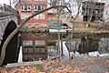
Foundation remnants lining the Mystic River in Somerville and Medford


Other online archives of The New England Magazine. This is how the Middlesex Canal Corporation was dissolved.
Images for kids
-
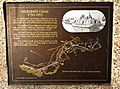
Plaque describing the canal in Medford, Massachusetts

