Mystic Valley Parkway facts for kids
 |
|
|---|---|
| Maintained by | Department of Conservation and Recreation |
| Length | 6.0 mi (9.7 km) |
| Location | Mystic River Reservation, Middlesex County, Massachusetts |
| West end | |
| East end | |
| Construction | |
| Completion | 1895 |
| Other | |
| Designer | Olmsted Brothers |
|
Mystic Valley Parkway, Metropolitan Park System of Greater Boston MPS
|
|
 |
|
| Location | Arlington, Medford, Somerville, and Winchester, Massachusetts |
| Area | 22 acres (8.9 ha) |
| Built | 1936 |
| Architect | Charles Eliot; Olmsted Brothers |
| MPS | Metropolitan Park System of Greater Boston MPS |
| NRHP reference No. | 05001529 |
| Added to NRHP | January 18, 2006 |
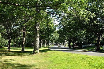
The Mystic Valley Parkway is a special road, or parkway, in Massachusetts. It goes through the towns of Arlington, Medford, Somerville, and Winchester. This parkway is listed on the National Register of Historic Places, which means it's an important historical site. It also forms part of Route 16.
What is the Mystic Valley Parkway?
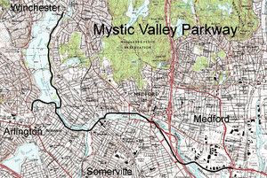
The Mystic Valley Parkway runs for about 6 miles (9.7 km). It generally goes from north to south. It starts near the Middlesex Fells in Winchester. From there, it follows the Aberjona River valley. It also runs along the east side of the Mystic Lakes. This part of the parkway follows an old path called the Middlesex Canal.
The parkway then crosses the Mystic River into Arlington. Here, it shares a bridge with Massachusetts Route 60. After crossing, it curves to follow the Mystic River as it flows east to west through Arlington. There's also a short section that runs along the southern shore of the Lower Mystic Lake. This section ends where it meets U.S. Route 3 and Massachusetts Route 2A.
The parkway then connects with Alewife Brook Parkway. This is where it joins with Massachusetts Route 16. It continues to follow the Mystic River downstream, crossing it a few times. The parkway finally ends where it meets Revere Beach Parkway and Massachusetts Route 28.
History of the Parkway
The Mystic Valley Parkway is part of a larger system of parks and roads around Boston. This system was created in 1893 and was called the Metropolitan Park District.
The parkway itself was designed between 1894 and 1895. It was created by famous landscape architects known as the Olmsted Brothers. Charles Eliot played a big role in its design. The idea was to build beautiful roads, called "pleasure roads," that people could enjoy. These roads were part of a bigger plan to create green spaces and parks all around Boston.
Over time, the Mystic Valley Parkway became part of the Metropolitan Park System of Greater Boston. Because of its historical importance and beautiful design, it was added to the National Register of Historic Places on January 18, 2006. This means it's recognized as a special place that should be protected.
 | Bayard Rustin |
 | Jeannette Carter |
 | Jeremiah A. Brown |


