Alewife Brook Parkway facts for kids
   |
|
|---|---|

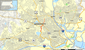
Map of Middlesex County in eastern Massachusetts with Alewife Brook Parkway highlighted in red
|
|
| Maintained by | Department of Conservation and Recreation and MassDOT |
| Length | 2.05 mi (3.30 km) |
| Location | Alewife Brook Reservation, Middlesex County, Massachusetts |
| South end | |
| North end | |
| Construction | |
| Completion | 1916 |
|
Alewife Brook Parkway
|
|

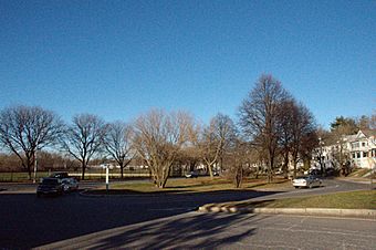
The parkway at Powder House Boulevard in Somerville
|
|
| Lua error in Module:Location_map at line 420: attempt to index field 'wikibase' (a nil value). | |
| Location | Cambridge and Somerville, Massachusetts |
| Built | 1908 |
| Architect | Charles Eliot; Olmsted Brothers |
| MPS | Metropolitan Park System of Greater Boston MPS |
| NRHP reference No. | 04000249 |
| Added to NRHP | March 18, 2004 |
Alewife Brook Parkway is a short, scenic road in Cambridge and Somerville, Massachusetts. It's special because it's listed on the National Register of Historic Places, which means it's an important historical site.
This parkway starts near Fresh Pond in Cambridge. It then travels north along the side of Alewife Brook. The road crosses into West Somerville and ends at the Mystic River. Here, it changes into the Mystic Valley Parkway.
The entire length of Alewife Brook Parkway is part of Massachusetts Route 16. Some parts of it are also shared with Route 2 and U.S. Route 3. The road is looked after by the Department of Conservation and Recreation. The Massachusetts Department of Transportation helps keep its bridges in good shape.
About the Parkway Route
The parkway begins at a large traffic circle near Fresh Pond in Cambridge. This is where several important roads meet. From here, the parkway heads north. It runs right next to the Alewife station, which is a busy train and bus station.
As you travel north, the parkway follows along Alewife Brook. This brook forms the border between Cambridge and Arlington. You'll pass a major intersection with Massachusetts Avenue. This road leads to places like Porter Square.
The parkway continues into Somerville. After crossing Broadway, it goes through another large intersection near Powder House Boulevard. You'll also see Dilboy Stadium on your left. The parkway ends at a small traffic circle near where Alewife Brook flows into the Mystic River. Here, it connects to Mystic Valley Parkway. The total length of Alewife Brook Parkway is a little over two miles (about three kilometers).
History of Alewife Brook Parkway
Alewife Brook Parkway is part of a bigger plan called the Metropolitan Park System of Greater Boston. This system was created in 1893 to build parks and scenic roads. The parkway was designed by a famous landscape architect named Charles Eliot. He wanted to create beautiful roads for people to enjoy.
The nearby Alewife Brook was made straighter between 1909 and 1912. The parkway itself was finished by 1916. The landscaping, which means planting trees and shaping the land, was done by the well-known Olmsted Brothers company.
Over the years, the area around the parkway has changed a lot. In 1950, a drive-in movie theater was built. Later, in 1962, a shopping center took its place. An indoor movie theater was added next to the shopping center in 1964.
In the late 1980s, the southern part of the parkway got some big upgrades. These included new lanes, wider traffic circles, and special lanes for bikes. They also added new trees and lights. These changes made it easier for people to get around and enjoy the area.
Today, many cars use Alewife Brook Parkway every day. It's an important road for people traveling between the western suburbs and downtown Cambridge and Boston. The Alewife MBTA station is a very noticeable spot along the parkway. You can also see many shops, parking lots, and apartment buildings along the road.
Images for kids
 | Kyle Baker |
 | Joseph Yoakum |
 | Laura Wheeler Waring |
 | Henry Ossawa Tanner |


