Alewife Brook Reservation facts for kids
Quick facts for kids Alewife Brook Reservation |
|
|---|---|

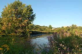
The Little River running through Alewife Brook Reservation
|
|
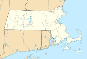
| Location | Cambridge, Somerville, Arlington, Middlesex, Massachusetts, United States |
| Area | 136 acres (55 ha) |
| Elevation | 12 ft (3.7 m) |
| Established | 1900 |
| Named for | Alewife Brook |
| Governing body | Massachusetts Department of Conservation and Recreation |
| Website | Alewife Brook Reservation |
Alewife Brook Reservation is a cool Massachusetts state park. It's also called an urban wild. This means it's a natural area right inside a city. You can find it in Cambridge, Arlington, and Somerville.
The state's Department of Conservation and Recreation takes care of the park. It was created way back in 1900. The park gets its name from Alewife Brook. This brook was once known as Menotomy River. It flows into the Mystic River.
Contents
Discover Alewife Brook Reservation
A big part of this park is made of wetlands. Wetlands are like spongy, watery areas. They include the Little River. But there are also wooded areas and open meadows.
The reservation is a home for many animals. Lots of local and migratory birds live here. You might spot an osprey or a great blue heron. The woodcock also lives here. Its unique mating dance is sometimes seen by visitors.
The park has three ponds: Little Pond, Perch Pond, and Blair Pond. In spring, special fish called anadromous herring come here to lay eggs. They travel all the way from the Atlantic Ocean. They swim through the Mystic River and Alewife Brook.
Exploring the Park
The biggest part of the park is next to the Alewife Station. This is where the MBTA Red Line ends in Cambridge. The popular Minuteman Bikeway also finishes here.
Other paths like the Fitchburg Cutoff Path and Alewife Greenway run through the park. Alewife Brook flows north through Cambridge, Arlington, and Somerville. It heads towards the Mystic River.
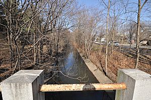
Much of the brook's path is narrow. It has the Alewife Brook Parkway next to it. There are small strips of land on either side. North of Broadway, the area opens up. Here you'll find playgrounds and playing fields. There's also Dilboy Stadium.
Blair Pond is south of the Fitchburg Line. You can get to it from Mooney Street and Normandy Ave. There are paths or sidewalks along the brook. These are being made even better as part of the Alewife Greenway project. Little Pond is surrounded by fences. So, you cannot easily reach its shoreline.
History of the Reservation
Railroads were built through this swampy area long ago. The Fitchburg Railroad main line came in 1843. It's now the MBTA Commuter Rail Fitchburg Line. Other rail lines followed, connecting different towns. They helped move goods like ice from Spy Pond.
In 1870, the Boston and Lowell Railroad bought a line. They built a connection from Alewife to Somerville. Today, parts of these old rail lines are bike paths. These include the Somerville Community Path and Alewife Linear Park. Old maps from 1903 show many railroads here. The swampy area was mostly undeveloped then.
The park was first planned by Charles Eliot. This was around the same time as the Alewife Brook Parkway. It's part of Boston's Metropolitan Park District. This system was set up in 1893. Alewife Brook was straightened between 1909 and 1912. This helped control its flow. The famous Olmsted Brothers firm did the landscaping.
Stormwater Management Wetland
Starting in 2011, the City of Cambridge built something new. It's a 3.4-acre stormwater management wetland. It's located west of Alewife Station. This project opened in October 2013.
This wetland helps manage rainwater. It collects runoff from nearby parts of Cambridge. A special basin and plants slow the water down. This helps remove dirt and pollution. Then, cleaner water flows into the Little River.
The area also has an amphitheater and boardwalks. There are signs to teach visitors about nature. It connects the bike paths on both sides. Different types of habitats were created here. These include deep marsh and forest areas.
Long ago, the land near Massachusetts Bay was full of wetlands. These wetlands naturally cleaned water. They also helped control river flow. But as cities grew, these natural areas were damaged. This led to water pollution.
To fix this, the city was told to separate its sewage and stormwater pipes. In 2003, the Department of Conservation and Recreation worked with the Massachusetts Water Resource Authority. They planned to restore a neglected wetland. They also wanted to make the reservation a public park.
This plan worked very well! It improved water quality. It also reduced flooding and sewage overflows. The project helped nature too. It created safe homes for urban wildlife. It also made the city more sustainable.
The park's renewal created a shared public space. It helps people feel connected. It also offers chances to learn about the environment. There are outdoor classroom spaces built into the park's design.
However, not everyone agreed with the project. Some people had concerns about using parkland for this project. Also, the cost grew a lot. It was first estimated at $3 million. But it became part of a $171 million investment. This big cost increase caused some debate.
Alewife Brook Greenway
A bike path project for the reservation got $4.5 million. This money came from the American Recovery and Reinvestment Act of 2009. The Alewife Greenway is a 1.5-mile bike path. It follows the parkway from the Mystic River. It ends near Alewife station at the Minuteman Bikeway. This path was finished in October 2012.
See Also
 | James Van Der Zee |
 | Alma Thomas |
 | Ellis Wilson |
 | Margaret Taylor-Burroughs |


