
Fitchburg Cutoff facts for kids
Quick facts for kids Fitchburg Cutoff |
|
|---|---|

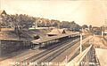
Somerville Highlands station on a 1907 postcard
|
|
| Overview | |
| Owner | Boston and Maine Railroad |
| Termini | Hills Crossing Somerville Junction |
| Stations | 3 |
| History | |
| Opened | 1870, 1881 |
| Closed | 1979–80, 2007 |
| Technical | |
| Line length | 2.8 mi (4.5 km) |
The Fitchburg Cutoff was a short railway line in Massachusetts. It ran for about 2.8 miles (4.5 km) (4.5 kilometers) from Belmont to Somerville. This line was built in two parts, first in 1870 and then in 1881.
Trains carried passengers on the line until 1927. After that, it was only used for moving goods (freight). Freight service stopped between 1979 and 1980. This was to make way for a new subway line called the Red Line Northwest Extension. The railway line was completely closed down in sections in 1979, 1983, and 2007.
Today, most of the old railway path has been turned into fun trails for walking and biking. These trails include the Fitchburg Cutoff Path, the Alewife Linear Park, and the Somerville Community Path. These paths are also part of a bigger trail system called the Mass Central Rail Trail.
Contents
The History of the Fitchburg Cutoff
How the Railroad Started
The Fitchburg Cutoff was built to connect two important railway lines. These were the Fitchburg Railroad (now the MBTA Fitchburg Line) and the Boston and Lowell Railroad (now the MBTA Lowell Line). The cutoff started near Brighton Street in Belmont. It then went through Davis Square and Somerville Highlands. Finally, it joined the Lowell Line at Somerville Junction.
The eastern part of the cutoff was built in 1870. It helped connect a newly bought railway line, the Lexington Branch, to the main Boston and Lowell line. There were stations along this part of the line. These included North Cambridge, West Somerville, Willow Avenue, and Somerville Highlands.
The western part of the cutoff was built later, in 1881. This section connected the Central Massachusetts Railroad to the Boston and Lowell line. It did not have any stations between Hills Crossing and North Cambridge.
In 1926 and 1927, some new tracks were built. These changes allowed trains from the Lexington Branch and Central Massachusetts Railroad to use the main Fitchburg line. Because of this, passenger service on the Fitchburg Cutoff stopped on April 24, 1927. The line then became only for freight trains. The stations at North Cambridge, West Somerville, and Somerville Highlands were closed.
Most of the cutoff was closed in 1979 and 1983. This was done to build the Red Line Northwest Extension subway. The subway now runs underneath parts of the old cutoff. A small section at the eastern end of the cutoff was closed in 2007.
From Trains to Trails
After the railway closed, much of its path was turned into trails for people to enjoy.
The Alewife Linear Park
The 1.3-mile (2.1 km) Alewife Linear Park was built as part of the Red Line subway project. It opened in 1985. This park follows most of the old railway route from Alewife to Davis Square.
The Somerville Community Path
The Somerville Community Path opened in 1992. It stretched for 0.6 miles (0.97 km) from Davis Square to Cedar Street. A part of the Alewife Linear Park also became part of this path. In 1993, the Minuteman Bikeway connected to the trail at Alewife station.
In 2011, a safer way to cross Massachusetts Avenue was added. This made it easier for people on the path to cross the busy street. In 2015, the Community Path was extended another 0.3-mile (0.48 km) to Lowell Street. There are plans to extend it even further in the future.
The Fitchburg Cutoff Path
The 0.8-mile (1.3 km) section west of Alewife station was used as an unpaved trail for a while. In the 1990s, a stone dust surface was added. Then, the paved Fitchburg Cutoff Path was built between 2010 and 2013. A new bridge was also built over a wetland near Alewife.
There are plans for a new Belmont Community Path. This path will go west through Belmont, next to the Fitchburg Line. It will connect to other parts of the Mass Central Rail Trail.
Images for kids
-
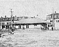
West Somerville station in 1903
-
Somerville Junction station was located near where the Fitchburg Cutoff met the Lowell mainline
-
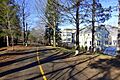
A typical section of Alewife Linear Park


