Revere Beach Parkway facts for kids
  |
|
|---|---|

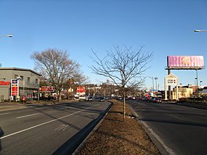
Looking eastbound at Everett Avenue in Everett
|
|
| Part of | |
| Maintained by | Department of Conservation and Recreation |
| Length | 5.3 mi (8.5 km) |
| Location | Greater Boston, Massachusetts |
| West end | |
| East end | |
|
Revere Beach Parkway—Metropolitan Park System of Greater Boston
|
|
| Location | Medford, Everett, Chelsea, and Revere, Massachusetts |
| Built | 1899 |
| Architect | Charles Eliot |
| MPS | Metropolitan Park System of Greater Boston MPS |
| NRHP reference No. | 07001241 |
| Added to NRHP | December 6, 2007 |
The Revere Beach Parkway is a special road in the suburbs just north of Boston, Massachusetts. It's not just any road; it's a historic parkway, which means it was designed to be a scenic route, often with green spaces nearby.
This parkway starts in Medford at a place called Wellington Circle. From there, it travels east, passing through the cities of Everett and Chelsea. The journey ends at Eliot Circle in Revere, near the famous Revere Beach.
The parkway was built a long time ago, between 1896 and 1904. Its main purpose was to help people from inland towns easily get to Revere Beach, which was a very popular spot for fun and relaxation. Over the years, the road was made bigger twice, once in the 1930s and again in the 1950s, to handle more cars.
Today, parts of the Revere Beach Parkway are known as Route 16 and Route 145. Because of its important history and design, the parkway was added to the National Register of Historic Places in 2007. This means it's recognized as a special place worth protecting.
Contents
Building the Parkway: A Look at Its History
The idea for the Revere Beach Parkway came from a landscape architect named Charles Eliot. He was a very important person in designing parks and scenic roads. He first suggested the parkway in a report back in 1893.
Early Construction and Design
Work on the parkway began in 1897. One of the first big projects was building a bridge over the railroad tracks. This bridge was later made longer, but part of the original bridge from 1899 is still there today.
In 1898, people started mapping out the best path for the road through Chelsea and Everett. The Olmsted Brothers, famous landscape designers, helped with the plan. They suggested making the road wider in areas where land was cheaper. By 1899, the entire route was planned, and the eastern part of the parkway was finished.
Expanding the Parkway
Building the middle section of the parkway, between Winthrop Avenue and Main Street in Everett, happened from 1900 to 1901. This part was tricky because it needed to cross more railroad tracks. In 1903, a special type of bridge called a "pony truss bridge" was built to go over these tracks. This is the oldest bridge still standing on the parkway!
The last part of the parkway, from Main Street in Everett to the Fellsway, was built between 1903 and 1905. This section included three important bridges. Two bridges went over railroad tracks, and one was a drawbridge over the Malden River. A drawbridge is a bridge that can open to let boats pass underneath.
Over the years, the parkway has been changed a lot, mostly to make it wider for more traffic. However, you can still find two places where the original road path remains. One is the Poirer Memorial Roadway, and the other is an access road in Revere. These small sections give us a glimpse into how the parkway looked when it was first built.
Main Road Connections
The Revere Beach Parkway connects to many other important roads and places. Here are some of its major intersections:
| County | Location | Mile | Roads intersected | Notes | |
|---|---|---|---|---|---|
| Middlesex | Medford | 0.0 | 0.0 | Route 16 / Parkway continues west | |
| 0.4 | 0.64 | Exit on Westbound Route 16 towards Rivers Edge Dr, Direct exit on Eastbound Route 16 to Wellington Station. | |||
| Everett | 0.6– 1.3 |
0.97– 2.1 |
Traffic circle with additional eastbound entrance | ||
| 2.7– 3.2 |
4.3– 5.1 |
Interchange with additional westbound exit | |||
| Suffolk | Revere | 3.6 | 5.8 | Interchange; southern terminus of Route 107 | |
| 4.3 | 6.9 | Parkway turns onto Winthrop Avenue; western terminus of Route 145 | |||
| 4.4 | 7.1 | Interchange | |||
| 5.3 | 8.5 | Elliot Circle; to Revere Beach Reservation; Route 145 continues east | |||
| 1.000 mi = 1.609 km; 1.000 km = 0.621 mi | |||||
 | Audre Lorde |
 | John Berry Meachum |
 | Ferdinand Lee Barnett |


