
Stoneham, Massachusetts facts for kids
Quick facts for kids
Stoneham
|
||
|---|---|---|
| Town of Stoneham | ||

Welcome sign of Stoneham
|
||
|
||

Location in Middlesex County in Massachusetts
|
||
| Country | ||
| State | ||
| County | Middlesex | |
| Region | New England | |
| Settled | 1645 | |
| Incorporated | 1725 | |
| Government | ||
| • Type | Open town meeting | |
| Area | ||
| • Total | 17.4 km2 (6.7 sq mi) | |
| • Land | 15.9 km2 (6.2 sq mi) | |
| • Water | 1.5 km2 (0.6 sq mi) | |
| Elevation | 47 m (155 ft) | |
| Population
(2020)
|
||
| • Total | 23,244 | |
| • Density | 1,336/km2 (3,469/sq mi) | |
| Time zone | UTC-5 (Eastern) | |
| • Summer (DST) | UTC-4 (Eastern) | |
| ZIP code |
02180
|
|
| Area code(s) | 339 / 781 | |
| FIPS code | 25-67665 | |
| GNIS feature ID | 0618235 | |

_map.jpg)

Stoneham (pronounced STO-nəm) is a town in Middlesex County, Massachusetts, United States. It is located about nine miles (14.5 km) north of downtown Boston. In 2020, about 23,244 people lived there.
Stoneham is close to major highways and public transportation. This makes it easy to get to Boston. It also offers good access to the North Shore coastal region and beaches. The town is famous as the birthplace of Olympic figure skater Nancy Kerrigan. It is also home to the Stone Zoo.
Contents
A Look at Stoneham's Past
Early Days and First Settlers
The first time Stoneham's land was written about was in 1632. On February 7, Governor Winthrop and his group explored the area. They found a place called Spot Pond. They ate lunch on a rock they named Cheese Rock, which is now known as Bear Hill. Stoneham is built on the traditional lands of the Massachusett and Pawtucket Native American peoples.
Colonists first settled in Stoneham in 1634. At first, it was part of Charlestown. By 1678, six families lived in the northeast part of the town. They likely chose this spot because it was near the settlement in Reading (now Wakefield).
Becoming Its Own Town
By 1725, the area, then called "Charlestown End," had grown. There were 65 men who paid taxes. However, they were many miles from Charlestown's church and school. Because of this, Captain Benjamin Geary and 53 other residents asked Charlestown to let them form their own town.
Charlestown first said no. But on December 17, 1725, the General Court (the state's legislature) passed a law. This law created the new town of Stoneham. It separated Stoneham from Charlestown. The residents no longer had to pay taxes to Charlestown. In return, they had to build a church and hire a minister and a schoolteacher within two years.

Stoneham's first meetinghouse was built in 1726. Its first cemetery, now called the Old Burying Ground, was also created then. This cemetery is now on the National Register of Historic Places. The first church was started in 1729. Its members came from churches in Reading and Melrose. That same year, the town decided to spend money to build a school. They also chose a group to hire a schoolmaster.
Stoneham stayed a small town during the time of the American colonies. You can still see parts of its colonial history. These are found in the Spot Pond Archeological District within the Middlesex Fells Reservation. Later, during the Industrial Revolution, Stoneham grew. It became a major center for making shoes.
Where is Stoneham?
Stoneham is located at coordinates 42.480145 degrees North and -71.098352 degrees West.
The town covers a total area of about 6.7 square miles (17.4 square kilometers). About 6.2 square miles (15.9 square kilometers) is land. The remaining 0.6 square miles (1.5 square kilometers) is water.
Stoneham has two exits from Interstate 93. These are Winchester Highlands and Montvale Avenue. It also has one exit from Interstate 95, which is Route 28.
Stoneham shares its borders with several other towns. These include Woburn, Winchester, Medford, Melrose, Wakefield, and Reading.
People of Stoneham
Population and Diversity
As of 2022, about 22,992 people lived in Stoneham. There were about 9,654 households. The town has a mix of different backgrounds. About 83.6% of the people are White. About 7.4% are Asian, and 1.6% are Black or African American. About 5.5% of residents come from two or more races. People of Hispanic or Latino heritage make up 4.7% of the population.
Many people in Stoneham have Italian roots, about 27.5%. A large number also have Irish heritage, about 26.9%. Other groups include those with English, German, and French ancestry.
Age and Households
About 19.7% of the population is under 18 years old. About 19.5% are 65 years or older. The average age in Stoneham is about 42.1 years.
About 25.9% of households have children under 18 living with them. About 35.1% of households have seniors aged 65 or older. Many households are married couples living together, about 51.2%.
Income and Economy
The average income for a household in Stoneham was about $112,935. For families, the average income was higher, around $153,873. The average income per person was about $60,043.
A small number of people, about 4.7%, live below the poverty line. This includes about 3.1% of children and 8.0% of seniors.
Getting Around Stoneham
Stoneham is located within the Route 128 area. This is a major highway loop around Boston. There are many ways to get around using public transportation.
The Tri-Community Greenway path runs through Stoneham. It's great for walking and biking. The Oak Grove subway station is about 3.8 miles (6.1 km) from Stoneham Center. This station is the last stop on the MBTA's Orange Line.
Several train stations are in nearby towns like Melrose and Winchester. These stations offer commuter rail service to Boston's North Station. The MBTA's 132 bus route goes through Stoneham Center. It connects to the Orange Line at Oak Grove and Malden Station. There is also an express bus, the 325, that goes to downtown Boston.
Learning in Stoneham
Stoneham has public schools for all ages.
- High School: Stoneham High School
- Middle School: Stoneham Central Middle School
- Elementary Schools: Colonial Park School, Robin Hood School, and South School
There are also private schools in Stoneham. Greater Boston Academy is a Seventh-day Adventist school for Pre-K to 8th grade. Saint Patrick School is a Catholic school that also serves students from Pre-K to 8th grade.
Stoneham in the News
Stoneham gets its news from Boston television and radio stations. Major newspapers like the Boston Herald and the Boston Globe also cover the town. Stoneham has its own local newspaper, the Stoneham Independent.
The town also has a community-access television station called StonehamTV. It broadcasts local shows on Comcast, Verizon, and RCN cable systems.
The Nine O'Clock Horn
The Nine O'clock Horn is a special tradition in Stoneham. It's also known as the Nine O'clock Bell or Alarm. A horn sounds from the Stoneham Fire Station every day at 9 a.m. and 9 p.m.
In the past, the number of horn blasts would tell different groups to fight fires. It also alerted the town to other emergencies, like a missing child. Today, the 9 a.m. and 9 p.m. horns are mainly used to test the alert system. However, the Stoneham Fire staff say these horns are kept mostly because of tradition. The horn system works automatically.
Famous People from Stoneham
Many interesting people have connections to Stoneham:
- Ben Bagdikian (1920-2006), a journalist and author. He helped publish the important Pentagon Papers.
- Mario Cantone (born 1959), a well-known comedian and actor.
- Nancy Kerrigan, an Olympic medalist in figure skating in 1992 and 1994.
- Killer Kowalski, a famous professional wrestler.
- John "Pie" McKenzie, an NHL player who won the Stanley Cup with the Boston Bruins in 1970 and 1972.
- Mike Ness (born 1962), a musician and founder of the band Social Distortion.
- Buffy Sainte-Marie (born 1941), a singer-songwriter, musician, and social activist.
Sports in Stoneham
Besides the sports teams at Stoneham High School, the town also has the Stoneham Sabers. This is an amateur baseball team in the Yawkey Baseball League of Greater Boston.
Images for kids
-
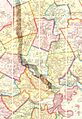
1852 map of Boston area showing Stoneham
-
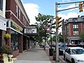
Main Street at the Stoneham Theatre
-
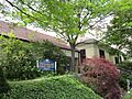
The Stoneham Public Library
See also
 In Spanish: Stoneham (Massachusetts) para niños
