Sandy Point State Reservation facts for kids
Quick facts for kids Sandy Point State Reservation |
|
|---|---|
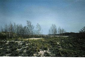
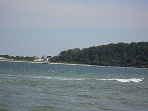
View south from Sandy Point. Castle Hill, Ipswich, is visible across the bay. The trees are white birch.
|
|
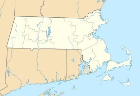
| Location | Ipswich, Essex, Massachusetts, United States |
| Area | 134 acres (54 ha) |
| Named for | The extensive sand bank projecting into Ipswich Bay that appears at low tide and is a hazard when covered at high tide. |
| Governing body | Massachusetts Department of Conservation and Recreation |
| Website | Sandy Point State Reservation |
Sandy Point State Reservation is a beautiful coastal Massachusetts state park. It's located in the town of Ipswich at the very southern tip of Plum Island. The park is managed by the Department of Conservation and Recreation. It's a super important spot for birds like the piping plover and the least tern to build their nests. To get to Sandy Point, you usually drive through the Parker River National Wildlife Refuge, which is right next door.
Contents
Exploring Sandy Point's Geography
Sandy Point State Reservation sits on a big sandy strip of land at the southern end of Plum Island. This sandy strip is actually called "Sandy Point." The main road, Plum Island Drive, is a dirt road that leads to a hill called Bar Head. This hill was formed by glaciers long ago.
- Bar Head Rocks and Seals*
From Bar Head, you can see rocks called "Bar Head Rocks" reaching into the water. These rocks came from an old gravel pit from the 1800s. Sometimes, you might even spot harbor seals resting on these rocks! They are rare, so don't count on seeing one. If you do, remember to stay far away and never approach them.
- Sharks in the Water*
Because seals are around, their main predators, sharks, have also returned to the waters near Plum Island. While shark attacks are very rare, people do see sharks, including the great white shark. Swimmers should always be aware of the possible dangers.
- Stage Island Pool: A Bird Haven*
On the north side of Bar Head, there's a freshwater pond called Stage Island Pool. It was created from an old salt-making area from the 1800s. The pond is named after Stage Island, which is a long, narrow ridge of sand and gravel called an esker. This pool is a great place for many different birds to feed and rest. There's even an observation tower on nearby federal land where you can watch the birds in summer.
- Navigating Ipswich Bay*
The state park mostly includes the hill and the sand spit, which is a key feature for boats. Back in 1879, sailing guides warned captains about entering Ipswich River and Plum Island Sound. They said the sand bar at the entrance was always shifting, especially after big storms. The channel for boats goes between two sandbars: North Breaker (from Sandy Point) and South Breaker (near Castle Hill). At low tide, North Breaker is almost completely out of the water.
- Tricky Tides and Quick Sands*
Even today, the water in the channel can be as shallow as 5 feet (1.5 meters) at low tide. The tidal currents are super fast, and the sand near the low tide mark is very loose, forming quicksands! In the past, small cargo ships would sail up the Ipswich River. Now, you mostly see motorized recreational boats.
- Bar Head's Transformation*
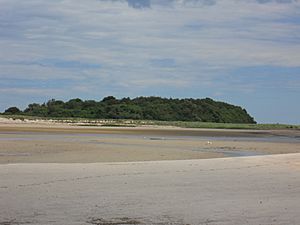
In 1879, Bar Head was estimated to be 40–50 feet (12–15 meters) high and had no trees. Today, the entire hill is covered with a thick, dense forest, which is a safe place for birds. There's a trail from the beach that leads to a wooden observation tower at the top.
A Glimpse into Sandy Point's Past
The names of places around Plum Island, like Bar Head and Stage Island, have been used for a very long time, since the 1600s! The land here was shaped by glaciers. Hills and ridges in the wetlands are often called "islands," even if they aren't completely surrounded by water. Bar Head was originally called Bar Island because of the sandbar extending from Sandy Point.
- Stage Island's History*
Just north of Bar Head is Stage Island, which is another esker. It was once called "the Bluffs." The name "stage" might come from a platform used for drying fish there long ago. From Sandy Point, you can also see other islands like Grape Island and Middle Island, as well as Castle Hill, Little Neck, and Jeffrey's Neck. These areas are separated from the mainland by wetlands.
- Early Days: Shared Land*
From 1634 to 1649, the southern part of Plum Island was open for anyone to use. People would let their farm animals, especially hogs, graze there in the summer. In 1649, the General Court of Massachusetts gave the southern two-fifths of Plum Island to the town of Ipswich, Massachusetts. At first, the town managed it as a "commons," meaning it was shared land. If the town harvested grass, it was given to those who didn't have any. Otherwise, people could harvest grass freely.
- Dividing the Land*
By 1664-1665, people wanted the land divided into individual lots. So, the Ipswich portion of Plum Island, along with Hog Island and Castle Neck, was split up and given to the town's residents. The size of the land a person received depended on how much wealth they had.
- Protecting the Land*
After the land was divided, the town tried to stop farm animals from roaming freely because they were damaging the land, especially the dunes. They also tried to stop people from cutting down trees and bushes, which helped keep the sand stable. These rules were in place for many years to protect the island's natural environment.
- Challenges for Landowners*
Owning land on Plum Island wasn't always easy. Many people weren't farmers, and the land was too sandy and salty for most crops. Only salt marsh hay grew well. The remote location also made it hard for people to build homes or farm their land. So, many new owners ended up selling their plots.
- The Rise of Estates*
Over time, wealthy individuals began buying up these smaller plots of land. Middle Island, for example, was good farmland and close to Ipswich. It was bought by John Pengry in 1693, who then leased it out as a farm. Later, in 1712-13, Nathaniel Emerson bought some land and started a fishing business there, with a wharf and warehouses. The Emerson Rocks are named after his family.
Another wealthy merchant, William Dodge, bought more land, including Stage Island and Bar Island. These large landholdings eventually became known as Cross Farm. The area, which now seems quiet and rural, was once a busy harbor with shipyards and warehouses. However, by the 1800s, businesses moved to Newburyport Harbor, and the region became less busy.
Dangers of Ipswich Bar
Ipswich Bar, also known as Sandy Point, has a long and sad history of shipwrecks. The strong currents and shallow waters are always dangerous, but they are especially deadly in winter storms. Sailing ships would get stuck on the bar. Even though land was very close, people often couldn't reach it through the freezing water and crashing waves. Many people didn't survive the cold water and strong waves. A cemetery was even set up on Bar Island for those who were lost at sea.
- The Wreck of the Falconer*
One of the biggest disasters was the wreck of the Falconer, a large ship carrying coal. On December 15, 1847, it ran into a huge winter storm. The ship had 53 people on board, including the captain's wife and son. The captain got lost in the fog and thought he was sailing into Boston Harbor, but he was actually in Ipswich Bay. He dropped anchor to wait out the storm, which turned out to be a fatal decision.
On the night of December 17, the storm got much worse, and the ship was pushed onto Ipswich Bar. It began to break apart in the huge waves. Help arrived from Ipswich, but it was a difficult rescue. Many people died from the cold wind and exposure. In total, 17 people lost their lives in this terrible wreck.
- Other Tragedies*
Many other ships also met their end on Ipswich Bar. In 1849, the Nancy sank, and all five crew members were lost. In 1850, the Argus foundered on Emerson Rocks, and the captain and some crew were lost. Over the years, many more ships, like the Ornament and the City Point, were wrecked here. Because of these dangers, shelters were built at Sandy Point in the 1800s to help sailors who were shipwrecked, but only scattered stones remain today. You can still see large pieces of old ship timber sticking out of the sand in the dunes, reminding visitors of these past tragedies.
Understanding Sandy Point's Ecology
The side of Plum Island facing inland is an estuary. An estuary is where fresh water from rivers mixes with salty ocean water. This area has four main types of natural environments:
- Salt marsh
- Fresh marsh
- Tidal creeks and bays
- Intertidal flats (areas covered by water at high tide and exposed at low tide)
- Plants of the Marshes*
In the fresh marsh areas, like Stage Island Pool, you'll see plants like Typha latifolia (common cattail). You might also spot Phragmites (common reed) and Lythrum salicaria (purple loosestrife), which are plants that have been introduced to the area.
Further north from Stage Island, you can see vast salt marshes with winding tidal creeks. At low tide, people often go shellfishing in the intertidal flats, digging for clams that are then cooked and sold in local restaurants. The salt marshes are home to special grasses like smooth cordgrass and marsh hay. Some haying still happens along the south of Plum Island today.
Fun Activities and Amenities
Sandy Point State Reservation offers lots of fun things to do!
- Beachcombing: Look for interesting shells and treasures along the shore.
- Fishing: Cast a line and try to catch some fish.
- Hunting: There is restricted hunting allowed in certain areas.
- Walking Trails: Explore the beautiful scenery on the park's trails.
- Birdwatching: This is a fantastic place to see many different kinds of birds, including seabirds, shorebirds, and field birds.
 | Selma Burke |
 | Pauline Powell Burns |
 | Frederick J. Brown |
 | Robert Blackburn |


