
Hamilton, Massachusetts facts for kids
Quick facts for kids
Hamilton, Massachusetts
|
||
|---|---|---|

Hamilton Town Hall
|
||
|
||

Location in Essex County and the state of Massachusetts.
|
||
| Country | United States | |
| State | Massachusetts | |
| County | Essex | |
| Settled | 1638 | |
| Incorporated | 1793 | |
| Government | ||
| • Type | Open town meeting | |
| Area | ||
| • Total | 14.9 sq mi (38.6 km2) | |
| • Land | 14.2 sq mi (36.7 km2) | |
| • Water | 0.7 sq mi (1.9 km2) | |
| Elevation | 49 ft (15 m) | |
| Population
(2020)
|
||
| • Total | 7,561 | |
| • Density | 507.3/sq mi (195.88/km2) | |
| Time zone | UTC−5 (Eastern) | |
| • Summer (DST) | UTC−4 (Eastern) | |
| ZIP Codes |
01936 (Hamilton), 01982 (South Hamilton)
|
|
| Area code(s) | 351/978 | |
| FIPS code | 25-27900 | |
| GNIS feature ID | 0619446 | |

Hamilton is a town in eastern Massachusetts, United States. In 2020, about 7,561 people lived there. Hamilton is a quiet town with no big factories.
Even though Hamilton isn't right on the coast, it's close to the Atlantic Ocean. This means you can easily visit beaches and go boating. You'll find many old houses, pretty countryside, and stone walls along its winding roads.
Hamilton has a strong connection to horses. Many horse farms are in the area. The Myopia Hunt Club often holds horse events, including polo games. You might even see people riding horses on the roads! Patton Park, a popular spot in downtown Hamilton, is named after General George S. Patton. It's a busy place for town activities.
Hamilton is very connected to its neighbor, Wenham. They share a school system, a library, a recreation department, a train station, and a newspaper.
A part of Hamilton is called South Hamilton. It has a different ZIP Code, but it's still the same town.
Contents
Hamilton's History: From Hamlet to Town
In 1638, John Winthrop the Younger bought most of what is now Essex County. He bought it from Chief Masconomet, who was the leader of the Agawam Indians. A special stone on Sagamore Hill in Hamilton marks where Masconomet was buried around 1658.
Early Settlement and Naming the Town
Hamilton was first settled in 1638. It was originally part of Ipswich and was known as "The Hamlet." The first land given out in The Hamlet was a farm in 1638. A few years later, a new road from Boston to Newburyport (called Bay Road) was built through this land. Early settlers were drawn to the area because it reminded them of the farms they had left in England.
The town officially became its own town on June 21, 1793. It was named after Alexander Hamilton, an important figure in American history. His picture became the town's official seal in 1903. When the Boston and Maine Railroad arrived in 1839, more people started living closer to the train station in the southern part of town.
Recreation and Community Life
Hamilton's countryside became a popular place for people from Boston to relax. In 1859, a group of Methodist ministers started holding camp meetings at Asbury Grove.
In the 1880s, the Myopia Hunt Club moved to Hamilton. This club started with lawn tennis and baseball, but its members soon became interested in polo, fox hunting, and golf. They built large summer homes in the area. The Myopia Hunt Club gave the land for the General George S. Patton Memorial Park to the town. This park is still a main spot for fun activities in Hamilton.
In 1921, the Mandell family built the Community House. They built it to remember the eight men from Hamilton and Wenham who died fighting in World War I. The Community House offers many classes and activities for people of all ages.
In 2021, Hamilton became the first town in Massachusetts to require composting.
-
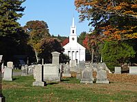
View of First Congregational Church from Hamilton Cemetery
-
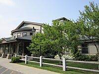
Hamilton-Wenham Public Library
-
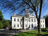
Hamilton Town Hall Hamilton, Massachusetts


Hamilton's Geography and Surroundings
Hamilton covers about 38.6 square kilometers (14.9 square miles). Most of this is land, with a small amount of water. The town is about 5 miles (8 km) from Massachusetts Bay. The Ipswich River runs along the western side of town, and Chebacco Lake is to the east.
Natural Features and Protected Areas
The highest point in Hamilton is Blueberry Hill, which is in Bradley Palmer State Park. It's at least 215 feet (66 meters) high. Several areas in town are protected, like parts of Bradley Palmer State Park, Appleton Farm Grass Rides, and the Ipswich River Wildlife Sanctuary. These places help protect nature and offer outdoor activities.
Neighboring Towns and Cities
Hamilton shares borders with several other towns. To the north is Ipswich. To the east is Essex, and to the southeast is Manchester-by-the-Sea. Wenham is to the south, and Topsfield is to the west. Hamilton is about 23 miles (37 km) northeast of Boston.
Getting Around Hamilton
Public Transportation
You can take the MBTA Commuter Rail from Boston's North Station to the Hamilton/Wenham station. This train station is close to the town hall, homes, and many small shops.
Roads and Airports
There are no major highways directly in Hamilton. The closest big highway, Route 128, is in Beverly. Route 1A goes through the center of Hamilton.
The closest small airport is Beverly Municipal Airport. For bigger flights, you can go to Boston's Logan International Airport.
Hamilton's People and Population
| Historical population | ||
|---|---|---|
| Year | Pop. | ±% |
| 1850 | 889 | — |
| 1860 | 789 | −11.2% |
| 1870 | 790 | +0.1% |
| 1880 | 935 | +18.4% |
| 1890 | 961 | +2.8% |
| 1900 | 1,614 | +68.0% |
| 1910 | 1,749 | +8.4% |
| 1920 | 1,631 | −6.7% |
| 1930 | 2,044 | +25.3% |
| 1940 | 2,037 | −0.3% |
| 1950 | 2,764 | +35.7% |
| 1960 | 5,488 | +98.6% |
| 1970 | 6,373 | +16.1% |
| 1980 | 6,960 | +9.2% |
| 1990 | 7,280 | +4.6% |
| 2000 | 8,315 | +14.2% |
| 2010 | 7,764 | −6.6% |
| 2020 | 7,561 | −2.6% |
| 2022* | 7,526 | −0.5% |
| * = population estimate. Source: United States Census records and Population Estimates Program data. |
||
In 2000, there were 8,315 people living in Hamilton. The population was 7,561 in 2020. Most people in Hamilton are White (94.19%), with smaller percentages of Asian (4.26%), African American (0.47%), and Native American (0.17%) residents. About 0.99% of the population was Hispanic or Latino.
Many households in Hamilton have children under 18. The average household had about 2.87 people. The median age in town was 36 years old.
Education in Hamilton
Hamilton is known for its good schools, which it shares with Wenham. Most of the schools in the Hamilton-Wenham Regional School District are located in Hamilton.
Local Schools
- Elementary Schools: The town has two elementary schools: Winthrop School and Cutler School.
- Middle School: Students attend Miles River Middle School.
- High School: High school students go to Hamilton-Wenham Regional High School.
Other Educational Institutions
The Pingree School, a private high school, is also in Hamilton. It's located on the historic Pingree Family Estate.
Hamilton is also home to Gordon-Conwell Theological Seminary, which is a school for religious studies.
Famous People from Hamilton
Many interesting people have connections to Hamilton:
- Bo Burnham: A comedian, musician, actor, and filmmaker.
- Michael Carter-Williams: A basketball player.
- Chief Masconomet: A Native American chief.
- George S. Patton: A famous U.S. Army general.
- David Morse: An actor.
- Kevin O'Connor: A television host.
- George von Lengerke Meyer: A U.S. ambassador and government official.
Historic Places to Visit
Hamilton has several historic spots:
- Asbury Grove
- Austin Brown House
- Brown House
- Emeline Patch House
- Hamilton Historic District
- Myopia Hunt Club: This club hosted the U.S. Open golf tournament several times in the early 1900s.
- Woodberry-Quarrels House
See also
 In Spanish: Hamilton (Massachusetts) para niños
