Wenham, Massachusetts facts for kids
Quick facts for kids
Wenham, Massachusetts
|
||
|---|---|---|
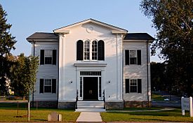
The Wenham Town Hall on Route 1A
|
||
|
||
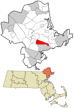
Location in Essex County and the state of Massachusetts.
|
||
| Country | United States | |
| State | Massachusetts | |
| County | Essex | |
| Settled | 1635 | |
| Incorporated | 1643 | |
| Government | ||
| • Type | Open Town Meeting | |
| Area | ||
| • Total | 8.1 sq mi (21.1 km2) | |
| • Land | 7.6 sq mi (19.8 km2) | |
| • Water | 0.5 sq mi (1.2 km2) | |
| Elevation | 105 ft (32 m) | |
| Population
(2020)
|
||
| • Total | 4,979 | |
| • Density | 611.2/sq mi (236.0/km2) | |
| Time zone | UTC−5 (Eastern) | |
| • Summer (DST) | UTC−4 (Eastern) | |
| ZIP Code |
01984
|
|
| Area code(s) | 351 / 978 | |
| FIPS code | 25-74595 | |
| GNIS feature ID | 0619455 | |
Wenham (/ˈwɛnəm/) is a small community in Essex County, Massachusetts. It is known as a "New England town," which means it has a local government where citizens can vote on important issues. In 2020, about 4,979 people lived there.
Wenham was first settled by English people in 1635. It became an official town in 1643. The town has kept its old-fashioned charm and beautiful countryside. You can see many open fields, lakes, forests, old homes, and stone walls along its winding roads. Wenham also has almost 300 acres of parks and places for fun activities.
Wenham works closely with its nearby town, Hamilton. They share schools, a library, a recreation department, a train station, and even a newspaper. In 2010, Boston magazine named the Hamilton-Wenham area one of the "Best Places to Live." Wenham, Massachusetts, is the only town with this name in the entire United States.
Contents
History of Wenham
Wenham was settled in 1635 and became an official town in 1643.
Early Settlers and Native Americans
English settlers arrived in Wenham in the 1630s. Before them, the area was home to the Agawam people. They were a Native American tribe whose population greatly decreased around 1617. This was likely due to a big sickness, possibly smallpox.
In 1700, three grandchildren of the Agawam Chief Masconomet claimed rights to the land. This land included Wenham, Beverly, and Manchester. Wenham leaders paid them a small amount of money to give up their claim. Old Native American tools and items are often found in Wenham. A collection of these items is kept at the Wenham Museum.
Wenham was originally part of Salem. Around 1638, Salem's minister, Hugh Peters, spoke to a group near Great Pond. He probably wanted to encourage more people to settle there. The first land given out in Wenham happened around the time of his speech. The hill where he spoke was later flattened for the ice business at the Great Pond.
Becoming an Independent Town
In September 1643, the General Court of Massachusetts decided Wenham should be its own town. This meant Wenham could send a representative to the General Court. It was the first town to become separate from Salem.
Wenham sent volunteers to fight in King Philip's War in the 1670s. They also helped in the French and Indian War in the mid-1700s. In 1774, the town voted to choose 15 men to be minutemen. These were soldiers ready to fight very quickly. After this, people who supported the British (called Loyalists) were not welcome in Wenham.
Important Places and People
In 1909, a rich steel businessman named Henry Clay Frick bought a property called Iron Rail. His daughter, Helen, wanted to create a vacation home there. This home was for young women who worked in mills across New England. In 1954, Helen Frick gave the Iron Rail Vacation Home to the Girls' Clubs of America. The town of Wenham bought the property in the 1970s.
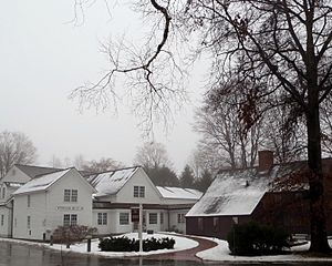
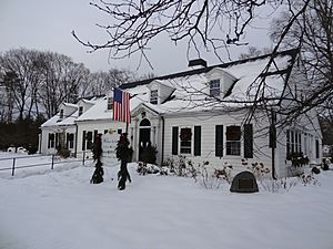
In 1921, a group called the Historical Committee of the Wenham Village Improvement Society bought the Claflin-Richards house. This house was built in the 1600s and is in the center of town. They later added a museum and a building called "the Barn," which became Burnham Hall. The Wenham Historical Association and Museum became its own group. It was greatly updated and made bigger in 1997.
Geography and Getting Around
Wenham covers about 8.1 square miles (21.1 square kilometers). About 7.6 square miles (19.8 square kilometers) is land, and 0.5 square miles (1.2 square kilometers) is water. It is not directly on the ocean. Wenham Lake is partly in Wenham and partly in Beverly. Other smaller ponds are also in town. A part of the Salem Beverly Waterway Canal goes through Wenham. The southern part of the Ipswich River Wildlife Sanctuary is in the western area of town.
Neighboring Towns and Roads
Wenham is surrounded by several other towns. To the south is Beverly. To the east is Manchester-by-the-Sea. To the north is Hamilton. To the northwest is Topsfield, and to the west is Danvers. Wenham is about 6 miles north of Salem and 21 miles north-northeast of Boston.
Major roads cross through Wenham. Massachusetts Route 128 goes through the eastern part of town. Route 1A runs through the town center. Route 22 is in the east, and Route 97 is in the southwest.
Public Transportation
Wenham is on the Newburyport section of the MBTA Commuter Rail. This train line connects to Boston. The Hamilton/Wenham station is right on the border between Hamilton and Wenham. The North Beverly station is also nearby in Beverly. The very end of a runway at Beverly Municipal Airport is just inside Wenham. For bigger flights, the closest major airport is Logan International Airport in Boston.
Population Information
| Historical population | ||
|---|---|---|
| Year | Pop. | ±% |
| 1850 | 977 | — |
| 1860 | 1,105 | +13.1% |
| 1870 | 985 | −10.9% |
| 1880 | 889 | −9.7% |
| 1890 | 886 | −0.3% |
| 1900 | 847 | −4.4% |
| 1910 | 1,010 | +19.2% |
| 1920 | 1,090 | +7.9% |
| 1930 | 1,119 | +2.7% |
| 1940 | 1,220 | +9.0% |
| 1950 | 1,644 | +34.8% |
| 1960 | 2,798 | +70.2% |
| 1970 | 3,849 | +37.6% |
| 1980 | 3,897 | +1.2% |
| 1990 | 4,212 | +8.1% |
| 2000 | 4,440 | +5.4% |
| 2010 | 4,875 | +9.8% |
| 2020 | 4,979 | +2.1% |
| 2022* | 4,926 | −1.1% |
| * = population estimate. Source: United States Census records and Population Estimates Program data. |
||
In 2000, there were 4,440 people living in Wenham. There were 1,285 households, and 957 families. The population density was about 575 people per square mile. Most people in Wenham were White (97.84%).
About 37.6% of households had children under 18. Most households (66.5%) were married couples. The average household had 2.70 people. The average family had 3.19 people.
The median age in Wenham was 34 years old. About 22.0% of the population was under 18. About 23.6% were between 18 and 24. The median income for a household in Wenham was $90,524. For a family, it was $98,004.
Education in Wenham
Wenham is home to Gordon College. This is a private four-year Christian college.
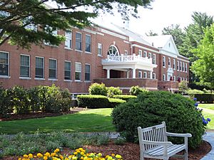
The Academy at Penguin Hall is also in Wenham. It is an independent high school just for girls. Girls in grades 9 through 12 attend this school. It helps prepare them for college.
Wenham is part of the Hamilton-Wenham Regional School District. The town has one public elementary school, called the Buker school. Middle school students go to Miles River Middle School. High school students attend Hamilton-Wenham Regional High School.
Places to Visit in Wenham
- Wenham Museum (opened in 1922)
- Claflin-Richards House (built around 1690)
- Grand Wenham Canal (built in 1917)
- Newman-Fiske-Dodge House (built around 1658)
- Wenham Lake
- The Academy at Penguin Hall
Famous People from Wenham
- Paul Harding, a writer who won a Pulitzer Prize for his book Tinkers
- Bob Stanley, a former baseball pitcher for the Red Sox
See also
In Spanish: Wenham (Massachusetts) para niños
 | Dorothy Vaughan |
 | Charles Henry Turner |
 | Hildrus Poindexter |
 | Henry Cecil McBay |


