
Manchester-by-the-Sea, Massachusetts facts for kids
Quick facts for kids
Manchester-by-the-Sea
|
||
|---|---|---|

The First Parish Church in central Manchester-by-the-Sea
|
||
|
||

Location in Essex County and Massachusetts
|
||
| Country | United States | |
| State | Massachusetts | |
| County | Essex | |
| Settled | 1629 | |
| Incorporated | 1645 | |
| Government | ||
| • Type | Open town meeting | |
| Area | ||
| • Total | 18.3 sq mi (47.3 km2) | |
| • Land | 9.2 sq mi (23.9 km2) | |
| • Water | 9.0 sq mi (23.4 km2) | |
| Elevation | 30 ft (9 m) | |
| Population
(2020)
|
||
| • Total | 5,395 | |
| • Density | 295.4/sq mi (114.06/km2) | |
| Time zone | UTC-5 (Eastern) | |
| • Summer (DST) | UTC-4 (Eastern) | |
| ZIP code |
01944
|
|
| Area code(s) | 351 / 978 | |
| FIPS code | 25-37995 | |
| GNIS feature ID | 0619451 | |

Manchester-by-the-Sea, often called just Manchester, is a pretty coastal town in Massachusetts, USA. It's located on a place called Cape Ann in Essex County. The town is famous for its beautiful beaches and amazing views. In 2020, about 5,395 people lived here.
This town sits on the southern part of Cape Ann, where the land connects to the main part of Massachusetts. Long ago, the Agawam people lived here before Europeans arrived in 1629. The town became official in 1645. For a long time, fishing was the main job. But in the mid-1800s, it became a popular place for people to visit and stay by the sea. Manchester-by-the-Sea has also been featured in movies and TV shows, including the famous 2016 film Manchester by the Sea.
Contents
History of Manchester-by-the-Sea

For thousands of years, Native American groups lived in what is now northeastern Massachusetts. The Agawam people lived in the Manchester area when Europeans first arrived in the early 1600s. Sadly, many of the Agawam people died from illnesses between 1617 and 1619. After this, only a small number of native people were left in the area.
English settlers first came to Manchester in 1629. The town officially became a town in 1645. Its land was taken from parts of Salem and Gloucester. In 1700, leaders from Manchester paid three grandchildren of the Agawam leader, Masconomet, for the rights to the land.
For over 200 years, the town was mostly a fishing community. But in 1845, things started to change. A poet named Richard Dana built a house here, and soon, people from Boston began to visit for their summer holidays. Over the next 50 years, many summer houses were built along the coast. This made Manchester-by-the-Sea a favorite summer spot for Boston's wealthy families. Famous architects designed some of these homes, like "Sunnywaters" in 1863.
One of the most famous "summer cottages" was Kragsyde. It was finished in 1885 for George Nixon Black. This house was designed by Peabody and Stearns and is known as a great example of the Shingle style of architecture. Sadly, Kragsyde was taken down in 1929.
Why the Name Changed
The town's name was officially changed in 1989 to "Manchester-by-the-Sea." This was done to avoid confusion with the much larger city of Manchester, New Hampshire, which is nearby. The decision was very close, with only 97 votes for the change and 95 against it. The state government approved the change on September 25, 1989.
The name "Manchester by the Sea" was already well-known. It was first used in 1877 by a Boston publisher named James T. Fields. He used it while attending a summer picnic that still happens today. Edward Corley, a long-time resident, was a big reason the name change happened.
Geography of Manchester-by-the-Sea
Manchester-by-the-Sea covers about 47.3 square kilometers (18.3 square miles). About 23.9 square kilometers (9.2 square miles) is land, and 23.4 square kilometers (9.0 square miles) is water. This means almost half of the town's area is water!
The town is located along the North Shore of Massachusetts Bay, which connects to the Atlantic Ocean. There are seven beaches along the coast. Several small islands are also found offshore, like Kettle Island and House Island.
The coast has many small coves. The largest is Manchester Harbor, which gets its water from Sawmill Brook and other small streams. The town also has several protected natural areas. These include Cedar Swamp Conservation Area, Coolidge Reservation, and Wyman Hill Conservation Area.
Manchester-by-the-Sea shares borders with other towns. To the west are Beverly and Wenham. To the northwest is Hamilton. Essex is to the north, and Gloucester is to the east. The town is about 9 miles (14 km) northeast of Salem and 24 miles (39 km) northeast of Boston.
Transportation in Manchester-by-the-Sea
Massachusetts Route 128 passes through Manchester-by-the-Sea. This road is one of the main highways around Greater Boston. Route 128 has two exits in town as it goes from Beverly to Gloucester. A small part of the road also crosses through a corner of Essex.
Route 127 also goes through the town from west to east, passing right through the town center. There is no direct bus service into Manchester-by-the-Sea. However, you can find bus service nearby in Gloucester and Beverly.
The town has a train station called Manchester. This station is part of the MBTA Commuter Rail's Newburyport/Rockport Line. This train line connects Rockport and other North Shore towns to Boston's North Station. The closest small airport is Beverly Municipal Airport. For bigger national and international flights, people use Boston's Logan International Airport.
Population and People
| Historical population | ||
|---|---|---|
| Year | Pop. | ±% |
| 1790 | 965 | — |
| 1800 | 1,082 | +12.1% |
| 1810 | 1,137 | +5.1% |
| 1820 | 1,201 | +5.6% |
| 1830 | 1,236 | +2.9% |
| 1840 | 1,355 | +9.6% |
| 1850 | 1,638 | +20.9% |
| 1860 | 1,698 | +3.7% |
| 1870 | 1,665 | −1.9% |
| 1880 | 1,640 | −1.5% |
| 1890 | 1,789 | +9.1% |
| 1900 | 2,522 | +41.0% |
| 1910 | 2,673 | +6.0% |
| 1920 | 2,466 | −7.7% |
| 1930 | 2,636 | +6.9% |
| 1940 | 2,472 | −6.2% |
| 1950 | 2,868 | +16.0% |
| 1960 | 3,932 | +37.1% |
| 1970 | 5,151 | +31.0% |
| 1980 | 5,424 | +5.3% |
| 1990 | 5,286 | −2.5% |
| 2000 | 5,228 | −1.1% |
| 2010 | 5,136 | −1.8% |
| 2020 | 5,395 | +5.0% |
| 2022* | 5,354 | −0.8% |
| * = population estimate. Source: United States Census records and Population Estimates Program data. |
||
In 2010, there were 5,136 people living in Manchester-by-the-Sea. These people lived in 2,147 households, and 1,444 of these were families. The town had about 562.7 people per square mile.
Most of the people in the town were White (97.6%). There were also smaller groups of Asian (0.9%), Native American (0.2%), and African American (0.1%) residents. About 1.5% of the population was Hispanic or Latino.
The average income for a household in the town was $95,243. For families, the average income was $109,760. A small number of families (4.5%) and people (5.1%) lived below the poverty line. This included 3.9% of those under 18 and 3.7% of those aged 65 or older.
Local News and Media
The local newspaper for Manchester-by-the-Sea is called The Manchester Cricket. It has been published every week since 1888. Only three families have owned this newspaper since it started.
Inside The Manchester Cricket, there is a special section just for the nearby town of Essex. This section is called The Essex Echo. The town also gets news from a larger regional newspaper, the Gloucester Daily Times.
Education in Manchester-by-the-Sea
Students in Manchester-by-the-Sea attend schools within the Manchester Essex Regional School District. This district serves both Manchester-by-the-Sea and the neighboring town of Essex.
Fun Places to Visit
Singing Beach
About 1 mile (1.6 km) from the town center is a special place called Singing Beach. It gets its name because the sand makes a squeaking sound when you walk on it! The sand also looks shiny and colorful when the sun sets. This beach is very popular in the summer. It's easy to get to from Boston because it's only about a 0.5 mile (0.8 km) walk from the MBTA train station.
At Singing Beach, you can also find a cool rock formation called "Eaglehead." It's a popular spot for rock climbing and other fun outdoor activities.
Other Interesting Places
- The Monoliths (Manchester-by-the-Sea) (also known as Agassiz Rock)
- Masconomo Park
- Coolidge Reservation
- Crow Island
- Kragsyde
- Smith's Point
- Manchester Historical Museum (Trask House)
- Tucks Point
- Cathedral Pines
Notable People from Manchester-by-the-Sea
Many interesting people have lived in or been connected to Manchester-by-the-Sea:
- Junius Brutus Booth Jr., who was the brother of John Wilkes Booth. He died in Manchester-by-the-Sea in 1883.
- Nat Faxon, a comedian and Oscar winner for his movie script for The Descendants.
- Josh Gates, a TV host known for shows like Destination Truth and Expedition Unknown. He used to live here.
- Rufus Gifford, who served as the United States ambassador to Denmark from 2013 to 2017.
- Elizabeth Porter Gould, a poet and author.
- Sprague Grayden, an actress.
- Henry Northey Hooper, a manufacturer and politician from Boston.
- William Northey Hooper, one of the people who helped start the sugar industry in Hawaii.
- Joe Lloyd, a professional golfer.
- James McMillan, a senator from Michigan who helped design the Washington Mall. He died at his summer home in Manchester-by-the-Sea in 1902.
- Susan Minot, an author.
- Ray Ozzie, a well-known software entrepreneur.
- George Putnam III, a trustee of Putnam Investments.
- Gardner Read, a composer.
- David I. Robinson, a politician.
- Jay Severin, a radio talk show host.
- Josiah Spaulding, a businessman, lawyer, and politician who led the Massachusetts Republican Party from 1965 to 1970.
Images for kids
-
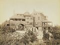
Kragsyde Mansion (1885, demolished 1929)
-
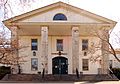
Town Hall
-
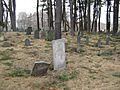
Old Burial Ground


See also
 In Spanish: Manchester-by-the-Sea para niños
