Georgetown, Massachusetts facts for kids
Quick facts for kids
Georgetown, Massachusetts
|
||
|---|---|---|

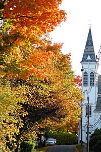
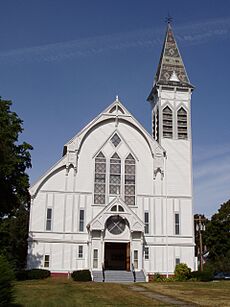
Spire of the First Congregational Church in Georgetown
|
||
|
||
| Nickname(s):
New Rowley
(former official name) |
||

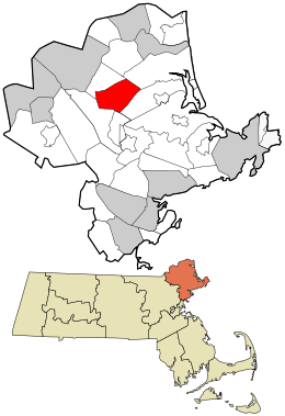
Location in Essex County and the Commonwealth of Massachusetts.
|
||
| Country | United States | |
| State | Massachusetts | |
| County | Essex | |
| Settled | 1639 | |
| Incorporated | 1838 | |
| Government | ||
| • Type | Open town meeting | |
| Area | ||
| • Total | 13.2 sq mi (34.1 km2) | |
| • Land | 12.9 sq mi (33.3 km2) | |
| • Water | 0.3 sq mi (0.8 km2) | |
| Elevation | 79 ft (24 m) | |
| Population
(2020)
|
||
| • Total | 8,470 | |
| • Density | 643.3/sq mi (248.4/km2) | |
| Time zone | UTC−5 (Eastern) | |
| • Summer (DST) | UTC−4 (Eastern) | |
| ZIP Code |
01833
|
|
| Area code(s) | 351/978 | |
| FIPS code | 25-25625 | |
| GNIS feature ID | 0619445 | |
Georgetown is a town in Essex County, Massachusetts, USA. In 2020, about 8,470 people lived here. It became its own town in 1838, separating from Rowley.
Contents
History of Georgetown
Georgetown was first settled in 1639. It was part of the town of Rowley. Reverend Ezekiel Rogers led the first settlers. At that time, Rowley stretched from the Atlantic Ocean to the Merrimack River. It was south of Newbury and north of Ipswich.
Farmers found good land in the western part of Rowley. They started settling along the Penn Brook in the mid-1600s. This area became known as Rowley's West Parish. Even though it wasn't directly in King Philip's War, the village faced attacks from Native Americans.
The village grew and was called New Rowley. Small mills and a shoe company opened there. By 1838, the village was large enough to become its own town. It was renamed Georgetown. Small industries continued to grow. Today, Georgetown is mostly a residential area. It is a suburb north of Boston.
Geography and Location
Georgetown covers about 34.1 square kilometers (13.2 square miles). Most of this area is land (33.3 km² or 12.9 sq mi). About 0.8 km² (0.3 sq mi) is water. Georgetown is on the edge of hills and the coastal plain in northeastern Massachusetts.
The town has many streams and brooks. It also has two main ponds: Rock Pond and Pentucket Pond. Georgetown has several protected natural areas. These include the Georgetown-Rowley State Forest to the south. The Crane Pond Wildlife Management Area is to the north. The Lufkins Brook Area is to the west. A small part of the Boxford State Forest is in the southwest.
Getting Around Georgetown
Georgetown is about 16 kilometers (10 miles) east of Lawrence. It is 18 kilometers (11 miles) south-southwest of Newburyport. Boston is about 45 kilometers (28 miles) north of Georgetown.
The town shares borders with other towns. Groveland is to the northwest. Newbury is to the northeast. Rowley is to the southeast. Boxford is to the southwest.
Interstate 95 runs through the eastern part of Georgetown. There is one exit for Route 133. Route 133 goes from east to west through town. Route 97 crosses from northwest to south. Both routes meet for a short distance near the town center.
Georgetown does not have its own public transportation. The closest train service is in Rowley. This is on the Newburyport/Rockport Line of the MBTA Commuter Rail. The nearest airport is Logan International Airport in Boston.
Population and People
| Historical population | ||
|---|---|---|
| Year | Pop. | ±% |
| 1850 | 2,052 | — |
| 1860 | 2,075 | +1.1% |
| 1870 | 2,088 | +0.6% |
| 1880 | 2,231 | +6.8% |
| 1890 | 2,117 | −5.1% |
| 1900 | 1,663 | −21.4% |
| 1910 | 1,621 | −2.5% |
| 1920 | 1,478 | −8.8% |
| 1930 | 1,853 | +25.4% |
| 1940 | 1,803 | −2.7% |
| 1950 | 2,411 | +33.7% |
| 1960 | 3,755 | +55.7% |
| 1970 | 5,290 | +40.9% |
| 1980 | 5,687 | +7.5% |
| 1990 | 6,384 | +12.3% |
| 2000 | 7,377 | +15.6% |
| 2010 | 8,183 | +10.9% |
| 2020 | 8,470 | +3.5% |
| 2022* | 8,408 | −0.7% |
| * = population estimate. Source: United States Census records and Population Estimates Program data. |
||
In 2010, Georgetown had 8,183 people living in 2,937 households. About 2,290 of these were families. The town had about 620 people per square mile. There were 3,044 housing units.
Most people in Georgetown were White (96.9%). A small number were Black or African American (0.5%), American Indian (0.2%), or Asian (0.9%). About 1.7% of the population was Hispanic or Latino.
Many households (40.9%) had children under 18 living with them. Most households (66.9%) were married families. About 22.0% of households were not families. The average household had 2.78 people. The average family had 3.18 people.
The population's age was spread out. About 27.0% were under 18 years old. About 11.3% were 65 years or older. The average age was 41.8 years.
Education in Georgetown
Georgetown has its own school district. It is not part of a larger regional school system. The town has three schools:
- Perley Elementary School: This school is for preschool students only. It has won a Blue Ribbon Schools Program award.
- Penn Brook Elementary School: This school is on Elm Street. It serves students from kindergarten to 6th grade.
- Georgetown Middle-High School: This is the only middle and high school in town. It serves students from 7th to 12th grade.
The school colors for Georgetown High School are royal blue and white. Their sports teams are called the Royals. Their mascot is a mounted knight. They play in the Small School division of the Cape Ann League. On Thanksgiving Day, they have a football rivalry with Manchester-Essex Regional High School.
Students can also choose to attend Whittier Regional Vocational Technical High School. This school is in Haverhill. It offers vocational training for students in the eastern Merrimack Valley. There are also private schools nearby. The closest one is The Governor's Academy in Newbury.
Places to Visit in Georgetown

- Historic Homes: You can visit old houses like the Brocklebank-Nelson-Beecher House, Dickinson-Pillsbury-Witham House, and Adams–Clarke House.
- Georgetown Central School Memorial Town Hall: This building is important to the town's history.
- Erie 4 Fire Company: This is the oldest volunteer fire company in America that is owned by private citizens.
- Georgetown-Rowley State Forest: A great place for outdoor activities and enjoying nature.
- Goodrich Massacre Site: A historical site.
- The "Old Nancy" Cannon: This cannon was used in the Revolutionary War. You can see it at the Town Hall.
- Union Cemetery: This cemetery has an interesting history. Cuffee Dole, an African-American man, was buried on the edge of the cemetery. As the cemetery grew, his grave became more central.
- Georgetown Peabody Library: This is the town's public library. It was built with money from George Peabody. He was a famous giver who helped build many libraries and museums. The library finished a new addition and renovation in 2007.
Famous People from Georgetown
Many interesting people have connections to Georgetown:
- Matt Antonelli: A former professional baseball player.
- Pat Freiermuth: A tight end for the Pittsburgh Steelers football team.
- Charles Beecher: A minister, composer, and writer who preached and died in Georgetown.
- Paul Harding: An author who won the 2010 Pulitzer Prize for his book Tinkers.
- Oliver Waterman Larkin: An author who won the 1950 Pulitzer Prize for his book Art and Life in America.
- Terry O'Reilly: A former Boston Bruins hockey player who lived in Georgetown for a long time.
- Brian St. Pierre: A former NFL quarterback.
- Fred Tenney: A baseball player born in Georgetown.
- Jenny Thompson: A U.S. Olympic swimming star who lived in town when she was younger.
- John Updike: A famous novelist who lived in Georgetown from 1976 to 1982. His jogs around town inspired parts of his 1981 novel Rabbit Is Rich. This book won him several awards, including the Pulitzer Prize for Fiction.
Georgetown in Movies
Georgetown was a filming location for the movie The Women (2008). This movie starred many famous actresses like Eva Mendes, Meg Ryan, and Annette Bening. The main filming spot was at Camp Leslie, next to Pentucket Pond.
See also
 In Spanish: Georgetown (Massachusetts) para niños
 | George Robert Carruthers |
 | Patricia Bath |
 | Jan Ernst Matzeliger |
 | Alexander Miles |


