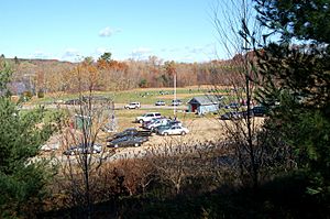
Groveland, Massachusetts facts for kids
Quick facts for kids
Groveland, Massachusetts
|
|||
|---|---|---|---|
| Town of Groveland | |||
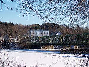
Old Bates Bridge on the Merrimack River in 2006
|
|||
|
|||
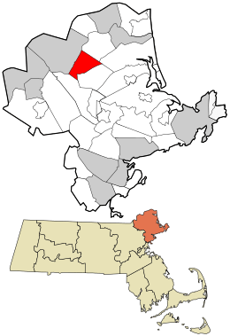
Location in Essex County and Massachusetts.
|
|||
| Country | United States | ||
| State | Massachusetts | ||
| County | Essex | ||
| Settled | 1639 | ||
| Incorporated | 1850 | ||
| Government | |||
| • Type | Open town meeting | ||
| Area | |||
| • Total | 9.4 sq mi (24.4 km2) | ||
| • Land | 9.0 sq mi (23.2 km2) | ||
| • Water | 0.5 sq mi (1.2 km2) | ||
| Elevation | 48 ft (15 m) | ||
| Population
(2020)
|
|||
| • Total | 6,752 | ||
| • Density | 716.7/sq mi (276.7/km2) | ||
| Time zone | UTC-5 (Eastern) | ||
| • Summer (DST) | UTC-4 (Eastern) | ||
| ZIP code |
01834
|
||
| Area code(s) | 351 / 978 | ||
| FIPS code | 25-27620 | ||
| GNIS feature ID | 0618298 | ||
Groveland is a town in Essex County, Massachusetts, United States. It is about 34 miles north of Boston. In 2020, about 6,752 people lived there. The town is split into two main areas: Groveland and South Groveland.
Contents
Discovering Groveland's Past
Groveland started as part of a town called Rowley. Later, it became the East Parish of Bradford. In 1850, Groveland officially became its own separate town. People in Groveland celebrate this day, September 9th, as "Groveland Day."
In 1638, a minister named Ezekiel Rogers left England with about 20 families. They were Puritans looking for a new home where they could practice their beliefs freely. They sailed to the New World on a ship that also carried America's first printing press.
They settled land between Ipswich and Newbury. This new settlement was first called Roger's Plantation. It was later named Rowley, after the English town. In 1639, this area became an official town. It included the land where Groveland, Georgetown, and other nearby towns are today.
The Congregational church in Groveland has a special bell. It was made by Paul Revere, who is famous for his ride during the American Revolution. This bell is one of only two still working from the 900 bells his company made!
You can also see the oldest hand-pump fire engine in the country in Groveland's town hall. It was built in 1798.
Exploring Downtown Groveland
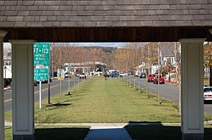
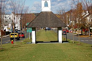
Groveland's downtown area is centered around Elm Park. This park is a newer addition to the town. Many years ago, tall elm trees grew everywhere. But around 1950, a disease called Dutch elm disease killed most of them.
Recently, new types of elm trees that can resist the disease were grown. So, the town built a new park and planted these special trees. Groveland is mostly a "bedroom community". This means many people live there but travel to other towns for work. So, it can be busy during rush hour. But after that, it becomes a quiet village where people ride bikes and walk.
Elm Park was first called Constitution Park in 1832. It got its new name in 1857 when the elm trees were planted. It was the first planned neighborhood in the area. Houses were built around the park, and residents could use a well at one end.
By the 1950s, the elm disease destroyed most of the trees. The last tree was removed in the early 1960s. But about 30 years later, people in Groveland worked hard to bring the park back. They got help from the state and other groups. Now, Elm Park looks like it did in the past.
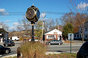
Today, visitors can walk on new sidewalks with lampposts like the old ones. There's a new fountain, a gazebo, and a clock. Large stone signs and monuments honor local veterans and share the town's history. The new elm trees are planted in the same way the original ones were.
The first post office for this area opened in 1810 in Bradford. After Groveland became its own town in 1850, a new post office was built on Main Street.
Geography and Getting Around Groveland
Groveland covers about 9.4 square miles. Most of this is land, and a small part is water. The town sits along the south side of the Merrimack River. Other smaller rivers and ponds, like Crane Pond and Johnson's Pond, are also in Groveland. A large part of the eastern side of town is a wildlife area called the Crane Pond Wildlife Management Area.
Groveland is in the northwest part of Essex County. It shares borders with towns like Haverhill, West Newbury, and Boxford. Groveland's town center is about 9 miles northeast of Lawrence.
No major highways go through Groveland. However, Route 97 and Route 113 both enter town over the Bates Bridge. This bridge connects Groveland to Haverhill. The old Bates Bridge was replaced by a new one in 2013.
For public transportation, the Merrimack Valley Regional Transit Authority has a bus route through town. You can also take a train from nearby Haverhill to Boston's North Station. The closest small airport is Lawrence Municipal Airport. For bigger flights, Logan International Airport in Boston is the nearest option.
Groveland's Climate
| Climate data for Groveland, Massachusetts (1991–2020 normals, extremes 1992–present) | |||||||||||||
|---|---|---|---|---|---|---|---|---|---|---|---|---|---|
| Month | Jan | Feb | Mar | Apr | May | Jun | Jul | Aug | Sep | Oct | Nov | Dec | Year |
| Record high °F (°C) | 72 (22) |
74 (23) |
89 (32) |
93 (34) |
95 (35) |
97 (36) |
100 (38) |
99 (37) |
94 (34) |
84 (29) |
80 (27) |
76 (24) |
100 (38) |
| Mean maximum °F (°C) | 58.1 (14.5) |
57.9 (14.4) |
67.0 (19.4) |
80.2 (26.8) |
89.7 (32.1) |
91.6 (33.1) |
93.9 (34.4) |
92.3 (33.5) |
88.7 (31.5) |
78.5 (25.8) |
69.9 (21.1) |
61.0 (16.1) |
95.8 (35.4) |
| Mean daily maximum °F (°C) | 35.3 (1.8) |
38.1 (3.4) |
45.7 (7.6) |
58.1 (14.5) |
68.9 (20.5) |
77.6 (25.3) |
83.1 (28.4) |
81.3 (27.4) |
73.4 (23.0) |
61.7 (16.5) |
50.6 (10.3) |
40.6 (4.8) |
59.5 (15.3) |
| Daily mean °F (°C) | 26.3 (−3.2) |
28.5 (−1.9) |
35.8 (2.1) |
47.0 (8.3) |
57.4 (14.1) |
66.6 (19.2) |
72.3 (22.4) |
70.5 (21.4) |
62.8 (17.1) |
51.1 (10.6) |
41.0 (5.0) |
31.8 (−0.1) |
49.3 (9.6) |
| Mean daily minimum °F (°C) | 17.3 (−8.2) |
18.8 (−7.3) |
26.0 (−3.3) |
35.9 (2.2) |
45.8 (7.7) |
55.6 (13.1) |
61.6 (16.4) |
59.7 (15.4) |
52.1 (11.2) |
40.5 (4.7) |
31.5 (−0.3) |
23.1 (−4.9) |
39.0 (3.9) |
| Mean minimum °F (°C) | −4.3 (−20.2) |
−1.1 (−18.4) |
6.2 (−14.3) |
21.1 (−6.1) |
30.8 (−0.7) |
41.4 (5.2) |
49.8 (9.9) |
46.1 (7.8) |
34.3 (1.3) |
24.1 (−4.4) |
16.0 (−8.9) |
4.3 (−15.4) |
−6.9 (−21.6) |
| Record low °F (°C) | −22 (−30) |
−16 (−27) |
−8 (−22) |
10 (−12) |
26 (−3) |
36 (2) |
45 (7) |
41 (5) |
29 (−2) |
14 (−10) |
6 (−14) |
−8 (−22) |
−22 (−30) |
| Average precipitation inches (mm) | 3.70 (94) |
3.61 (92) |
4.95 (126) |
4.16 (106) |
3.83 (97) |
4.20 (107) |
3.56 (90) |
3.37 (86) |
4.08 (104) |
4.92 (125) |
3.88 (99) |
4.72 (120) |
48.98 (1,246) |
| Average snowfall inches (cm) | 17.9 (45) |
17.2 (44) |
14.4 (37) |
2.4 (6.1) |
0.0 (0.0) |
0.0 (0.0) |
0.0 (0.0) |
0.0 (0.0) |
0.0 (0.0) |
0.4 (1.0) |
1.8 (4.6) |
13.0 (33) |
67.1 (170.7) |
| Average extreme snow depth inches (cm) | 11.7 (30) |
15.9 (40) |
11.7 (30) |
1.5 (3.8) |
0.0 (0.0) |
0.0 (0.0) |
0.0 (0.0) |
0.0 (0.0) |
0.0 (0.0) |
0.5 (1.3) |
0.5 (1.3) |
8.7 (22) |
20.8 (53) |
| Average precipitation days (≥ 0.01 in) | 12.0 | 10.6 | 11.5 | 10.9 | 12.5 | 11.6 | 9.5 | 9.2 | 9.0 | 11.0 | 10.6 | 11.7 | 130.1 |
| Average snowy days (≥ 0.1 in) | 8.0 | 7.2 | 5.4 | 1.3 | 0.0 | 0.0 | 0.0 | 0.0 | 0.0 | 0.3 | 1.3 | 5.3 | 28.8 |
| Source 1: NOAA | |||||||||||||
| Source 2: National Weather Service (mean maxima/minima, snow depth 2006–2020) | |||||||||||||
Groveland has a climate with warm summers and cold, snowy winters. The hottest month is usually July, with average temperatures around 72 degrees Fahrenheit. January is the coldest month, with average temperatures around 26 degrees Fahrenheit. The town gets a good amount of rain and snow throughout the year.
People and Population in Groveland
| Historical population | ||
|---|---|---|
| Year | Pop. | ±% |
| 1850 | 1,286 | — |
| 1860 | 1,448 | +12.6% |
| 1870 | 1,776 | +22.7% |
| 1880 | 2,227 | +25.4% |
| 1890 | 2,191 | −1.6% |
| 1900 | 2,376 | +8.4% |
| 1910 | 2,253 | −5.2% |
| 1920 | 2,650 | +17.6% |
| 1930 | 2,336 | −11.8% |
| 1940 | 2,122 | −9.2% |
| 1950 | 2,340 | +10.3% |
| 1960 | 3,297 | +40.9% |
| 1970 | 5,382 | +63.2% |
| 1980 | 5,040 | −6.4% |
| 1990 | 5,214 | +3.5% |
| 2000 | 6,038 | +15.8% |
| 2010 | 6,459 | +7.0% |
| 2020 | 6,752 | +4.5% |
| 2022 | 6,721 | −0.5% |
Source: United States Census records and Population Estimates Program data. |
||
In 2010, Groveland had 6,459 people living in 2,346 homes. Most of the people living in Groveland are White (about 97%). A small percentage are Asian, African American, or from other backgrounds. About 1.3% of the population is Hispanic or Latino.
Many homes in Groveland are families. About 34% of households have children under 18. Most families (65%) are married couples living together. The average household has about 2.75 people.
The median age in Groveland is about 43.5 years old. This means half the people are older than 43.5, and half are younger. About 24.7% of the population is under 18.
Learning in Groveland
Groveland is part of the Pentucket Regional School District. This district also includes the towns of West Newbury and Merrimac.
Groveland has one school, the Dr. Elmer S. Bagnall Elementary School. After elementary school, students go to Pentucket Regional Middle School and Pentucket Regional High School. These schools are located in West Newbury.
The Bagnall Elementary School also hosts the Groveland Summer Recreation Program. This is a popular summer camp for kids aged 6 to 15. It runs for seven weeks each summer. The program offers an extended day option for working parents.
Places of Worship
Groveland has several places where people can worship:
- Groveland Congregational Church, 4 King Street
- St James Episcopal Church, 121 Washington Street
- New Destiny Christian Church, 2 Esty Way
- St Patrick's Parish, 114 Center Street (part of Sacred Hearts Parish of Bradford)
Fun Things to Do in Groveland
Groveland has many places for fun and sports. You can find baseball and soccer fields, basketball courts, and picnic areas. There are also parks and places to launch boats on the Merrimack River.
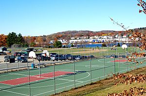
In 2005, Groveland built Elm Park in the town center. They also built a new basketball court at the Pines Recreation Area. Other interesting spots include Stickney's Boulder and Cedardale in North Groveland. South Groveland has Washington Park and Nuns' Hill.
Exploring The Pines Recreation Area
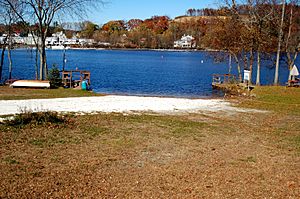
The Pines Recreation Area is a great place for outdoor activities. It has two basketball courts and two baseball fields. You can also have cookouts, bonfires, and watch fireworks there. Plus, you can access the Merrimack River for boating.
There's a nature trail that goes through a wooded area along the river. Cars are not allowed on this trail, so it's a quiet place for walking or jogging. For younger kids, the Pines also has swings and playground equipment.
Shanahan Field, a soccer field, is located in South Groveland. The Groveland Historical Society's building is right next to it.
Famous People from Groveland
- John G. B. Adams: An American soldier who received the Medal of Honor for his brave actions during the American Civil War.
- Larry Dorr: A lifelong resident of Groveland. He was the manager for the famous band Blood Sweat & Tears for 26 years, and also worked with many other musicians.
See also
 In Spanish: Groveland (Massachusetts) para niños
 | Jessica Watkins |
 | Robert Henry Lawrence Jr. |
 | Mae Jemison |
 | Sian Proctor |
 | Guion Bluford |


