
Yuba River facts for kids
Quick facts for kids Yuba River |
|
|---|---|

At South Yuba River State Park
|
|

Map of the Yuba River basin
|
|
| Other name(s) | Henneet, Rio De Los Yubas |
| Country | United States |
| State | California |
| Region | Nevada County |
| Cities | North San Juan, Marysville, Yuba City |
| Physical characteristics | |
| Main source | Confluence of North and Middle Yuba River Near North San Juan, Yuba/Nevada county line 1,129 ft (344 m) 39°22′07″N 121°08′11″W / 39.36861°N 121.13639°W |
| River mouth | Feather River Yuba City-Marysville, Yuba County 49 ft (15 m) 39°07′39″N 121°35′48″W / 39.12750°N 121.59667°W |
| Length | 39.7 mi (63.9 km) |
| Basin features | |
| River system | Feather River basin |
| Basin size | 1,345 sq mi (3,480 km2) |
| Tributaries | |
The Yuba River is a river in California. It flows into the Feather River. It starts in the Sierra Nevada mountains and goes through the eastern Sacramento Valley. The main part of the river is about 40 miles (64 km) long.
The Yuba River gets its water from three main branches. These are the North Yuba, Middle Yuba, and South Yuba Rivers. The Yuba River officially begins where the North and Middle Yuba Rivers meet. The South Yuba joins a bit further downstream. If you measure from the very start of the North Yuba River, the whole system is over 100 miles (160 km) long.
The river drains an area of 1,345 square miles (3,480 km2). This area is mostly in the western part of the Sierra Nevada mountains. The Yuba River provides about one-third of the water for the Feather River. It also gives about 10 percent of the water to the Sacramento River.
The river's name comes from a Maidu village called Yubu. This name was first used for the river around 1844. Some people think the name comes from the Spanish word uva, which means grapes. This is because grapes grew along the river banks.
Contents
River Branches and Flow
The Yuba River has three main branches. Each branch flows through different areas before joining the main river.
North Yuba River Journey
The North Yuba River is about 61.1 miles (98.3 km) long. It starts at Yuba Pass in the Tahoe National Forest. It flows southwest and then west through a deep canyon. This canyon is about 3,000 feet (910 m) deep.
It passes towns like Downieville and Goodyears Bar. Other creeks like Canyon Creek and Slate Creek join it. The river then turns south and flows into the New Bullards Bar Reservoir. This reservoir is held back by the 645 feet (197 m)-high New Bullards Bar Dam. About 5 miles (8.0 km) below this dam, it meets the Middle Yuba River. This is where the main Yuba River begins.
Middle Yuba River Path
The Middle Yuba River is about 55.4 miles (89.2 km) long. It starts in Moscove Meadow. It flows north into Jackson Meadows Reservoir. Then it turns west and enters a steep gorge.
Most of this river forms the border between Sierra County and Nevada County. It gets water from Kanaka Creek. Some of its water is sent to the North Yuba River at New Bullards Bar Reservoir. It also meets California State Route 49 near North San Juan. About 7 miles (11 km) downstream, it joins the North Yuba River.
South Yuba River Route
The South Yuba River is about 65.3 miles (105.1 km) long. It starts at Lake Angela in Nevada County. It gathers water from many snow-fed streams. It flows west through a valley with many lakes.
The river briefly enters Placer County. Then it flows back into Nevada County. It goes into Lake Spaulding. A lot of its water is sent south to the Bear River. The rest of the river turns north into a gorge. It then continues west. It receives water from Canyon Creek and Poorman Creek. The river flows into South Yuba River State Park. Finally, it joins the Yuba River at Englebright Lake.
Main Yuba River Flow

After the North and Middle Yuba Rivers join, the main Yuba River flows south. Then it turns southwest through the Sierra Nevada foothills. It forms the border between Yuba and Nevada Counties. The river gets wider and becomes part of Englebright Lake. The South Yuba River also joins it inside this lake.
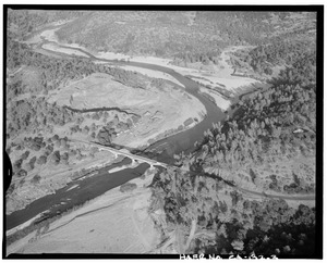
The river passes through the Englebright Dam. Then Deer Creek joins it. The Yuba River bed becomes very wide as it flows into the Sacramento Valley. This area is known as the Yuba Goldfields. This part of the valley has a lot of dirt and rocks. These were washed down by hydraulic mining in the 1800s. The river then turns southwest and flows through farms. It passes by Marysville. Finally, it empties into the Feather River between Marysville, Yuba City, and Linda.
Yuba River History

The Yuba River valley was once home to many Native American groups. These included the Maidu, Nisenan, and Miwok peoples. They lived in many small villages. Their main food was acorns. They also hunted and gathered other foods, like salmon from the Yuba River.
In the 1850s, the California Gold Rush brought many new settlers. These included people from Europe, Mexico, Africa, and China. These settlers brought diseases that the Native Americans had no protection against. Sadly, most of the native population died within a few years.
The Yuba River was one of the richest places for gold. Many miners came to the area. At first, they used simple ways to find gold, like panning. But then, large-scale hydraulic mining began. This method used powerful jets of water to wash away hillsides. This caused huge amounts of dirt and rock to flow into the river. About 25 million cubic yards of mining waste went into the Yuba River. This made the riverbed rise by up to 50 feet (15 m) in some places. It also buried land along the river and increased the risk of floods. This type of mining was stopped in 1884. This happened after farmers sued because their land was ruined.
Much of the waste from hydraulic mining is still there today. It forms the area called the Yuba Goldfields. Also, a lot of mercury was used to process gold. This caused a large area to become polluted. This pollution was still found in 2013 and is expected to last for over 10,000 years.
In 1877, the world's first long-distance telephone line was built along the South Yuba River. It went from French Corral to French Lake (now Bowman Lake). This was a distance of 58 miles (93 km).
Dams and Water Use
Like many rivers in California, the Yuba River has many dams. These dams were built in the 1900s. They help control floods and provide water for farms and towns.
The Daguerre Point Dam was built in 1906. Its purpose was to catch the mining waste. Later, in 1937, fish ladders were added to help fish move past the dam. The Englebright Dam was built in 1941. It also helped trap mining waste and now produces hydroelectricity.
The New Bullards Bar Dam was built on the North Yuba River. This happened after a big flood in 1955. This flood destroyed much of Yuba City. The dam was finished in 1969. It is 645 feet (197 m) high, making it one of the tallest dams in the United States. It holds a lot of water to help with flood control, farming, and making electricity.
The Yuba River Development Project includes the New Bullards Bar Dam. It also has other facilities. One is the Our House Dam, which sends water from the Middle Yuba River to the New Bullards Bar Reservoir. This helps make more electricity. The New Colgate Powerhouse makes over 1.3 billion kilowatt hours of energy each year. Because of these projects, some parts of the North Yuba and Middle Yuba Rivers have less water at certain times of the year.
The Middle Yuba River and South Yuba River are connected by two big projects. These are the Yuba-Bear and Drum-Spaulding projects. They have over 40 dams and reservoirs and 16 powerhouses. They make a lot of electricity. These projects also send some of the Yuba River's water to the Bear River.
Water Safety and Fish
The California Office of Environmental Health Hazard Assessment has given advice about eating fish from the Yuba River. They say it's important to be careful because of high levels of mercury in the fish.
River Branches and Creeks
Here are some of the smaller rivers and creeks that flow into the Yuba River, listed from the main river going upstream:
|
|
