
South Yuba River facts for kids
Quick facts for kids South Yuba River |
|
|---|---|

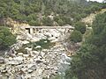
View of South Yuba from N Bloomfield Road Nevada City, CA
|
|
| Other name(s) | South Fork |
| Country | United States |
| State | California |
| Region | Upper Yuba Watershed |
| Physical characteristics | |
| Main source | Lake Angela Tahoe National Forest |
| River mouth | Englebright Lake Yuba River |
| Length | 65 mi (105 km), east-west |
| Basin features | |
| Basin size | 340 sq mi (880 km2) |
| Namesakes: South Yuba River State Park South Yuba River Citizens League |
|

The South Yuba River is a beautiful river in California. It flows for about 65 miles (105 km) through the northern Sierra Nevada mountains. This river is a branch of the larger Yuba River.
The South Yuba River starts at Lake Angela in Nevada County, California. This is near a place called Donner Pass. As it flows, it collects water from many smaller streams. These streams are fed by melting snow. The river then passes through Lake Spaulding. After that, it drops into a deep valley.
The river continues west into the lower hills. It eventually flows into Englebright Lake. This lake is formed by a dam on the main Yuba River.
It's important to know that you should not eat fish caught in the South Yuba River. This is because of certain chemicals in the water. These chemicals can make the fish unsafe to eat.
Exploring the South Yuba River
The South Yuba River is a great place for outdoor fun! It starts inside the Tahoe National Forest. This forest offers many chances to explore nature.
There are also special parks along or near the river where you can visit:
- Malakoff Diggins State Historic Park: This park shows the history of gold mining in the area.
- South Yuba River State Park: This park is a popular spot for swimming, hiking, and enjoying the river's beauty.
Images for kids
-
Bridge over the South Yuba River

