Malakoff Diggins State Historic Park facts for kids
Quick facts for kids Malakoff Diggins State Historic Park |
|
|---|---|

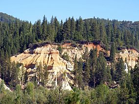
Canyon wall created by hydraulic mining at Malakoff Diggins State Historic Park
|
|
| Location | Nevada County, California, United States |
| Nearest city | Nevada City, California |
| Area | 3,143 acres (12.72 km2) |
| Established | 1965 |
| Governing body | California Department of Parks and Recreation |
|
Malakoff Diggins-North Bloomfield Historic District
|
|
| Area | 865 acres (350 ha) |
| Built | c. 1850–1899 |
| NRHP reference No. | 73000418 |
| Added to NRHP | April 11, 1973 |
Malakoff Diggins State Historic Park is a special state park in California. It protects Malakoff Diggins, which was the biggest hydraulic mining site in the state. This mine was part of an important court case in 1882. The park has a huge mining pit and old buildings from the Gold Rush era. These are listed on the National Register of Historic Places.
The "canyon" created by mining is 7,000 feet long. It is also up to 3,000 feet wide and nearly 600 feet deep in some spots. Visitors can see huge cliffs carved by powerful streams of water. This shows how miners washed away entire mountains to find gold. The park is 26 miles northeast of Nevada City, California. This area is known as Gold Rush country. The 3,143-acre park opened in 1965.
Contents
History of Gold Mining
The Malakoff mine pit helped start one of the first environmental protection efforts in the United States.
In 1850, it was hard to find gold in streams. Miners then found gold in old riverbeds and on mountainsides. In 1851, three miners went to a less crowded area to look for gold. One miner returned to town with gold nuggets. Many prospectors followed him back. But they found no gold and called the area "Humbug." So, the stream was named "Humbug Creek." Around 1852, a town called "Humbug" grew there. Miners struggled to move dirt to water sources.
The Invention of Hydraulic Mining
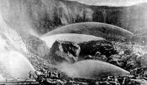
By 1853, miners invented a new way to mine called hydraulic mining. They built dams high in the mountains. Water flowed from these dams through long wooden canals called flumes. These flumes could be up to 45 miles long. The water rushed into canvas hoses with nozzles called monitors. Miners aimed these monitors at hillsides. The powerful water washed gravel into large sluices to find gold.
Over time, the monitors became bigger and more powerful. Their force was so great they could toss a 50-pound rock like a cannonball. They were also dangerous and could harm a person. More than 300 Chinese workers helped with this project. Two Chinese settlements existed in North Bloomfield.
North Bloomfield Town
By 1857, the town had grown to 500 residents. Locals felt the name "Humbug" was not good enough. They renamed the town "Bloomfield." But California already had a town with that name. So, they renamed it "North Bloomfield."
Environmental Impact and Lawsuit
In the late 1860s, the towns of Marysville and Yuba City were buried under 25 feet of mud and rock. Sacramento also flooded many times. Farmers in the valleys complained about the mining waste. This waste, called tailings, flooded their land and ruined their crops. Thousands of acres of rich farmland were destroyed by hydraulic mining.
By 1876, the mine was working at full power. Seven giant water cannons worked day and night. The town grew to about 2,000 people with many businesses. It also had daily stagecoach service. In 1880, electric lights were installed in the mine. The world's first long-distance telephone line was built for the mine. It passed through North Bloomfield on its way from French Corral to Bowman Lake.
By 1883, it was estimated that San Francisco Bay was filling with silt one foot each year. Debris, silt, and millions of gallons of water used daily by the mine caused huge floods. This led Sacramento valley farmers to file a lawsuit. The case was called Woodruff v. North Bloomfield Mining and Gravel Company. On January 7, 1884, Judge Lorenzo Sawyer ordered the mine to stop dumping waste into the rivers.
Climate and Weather
Malakoff Diggins is located at an altitude of 3,248 feet. It usually has warm, dry summers and cold, wet winters. The weather can change quickly at any time of year. Rain and snow typically fall from October to April. However, thunderstorms can also happen in the summer.
Exploring North Bloomfield
The visitor center has exhibits about life in the old mining town of North Bloomfield. This town once had 1,500 people and supplied the Diggins mine. About a block of buildings, some from the 1850s, have been restored. They look like a Gold Rush town, with white picket fences. One building is used as the park headquarters. There is also a museum with old items. A model shows how hydraulic mining worked.
In summer, park rangers lead tours. You can see a general store, a furnished home, and a drugstore. Its shelves are filled with old bottles and medicines. A church, schoolhouse, and other buildings are also part of the tour.
Park Activities
The park has many things to do. You can hike on trails, have a picnic, go swimming, or fish. There is a campground and rustic cabins you can rent for camping.
"Humbug Days" is an annual event. It includes a parade and a barbecue.
Hiking and Trails
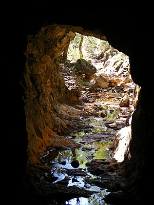
Visitors to the state historic park can hike on many miles of trails. The mining pit is open and easy to reach from the road and paths around it. Hikers can go into the 556-foot-long Hiller Tunnel. Water for the mining used to flow through this tunnel. The park also has a 7,847-foot bedrock tunnel that was used for drainage. Other hiking trails include:
- Rim Trail
- Diggins Loop Trail
- Blair Trail
- North Bloomfield Trail
Park Status
Malakoff Diggins was one of 70 California state parks that were considered for closure by July 2012. This was part of a plan to reduce the state's budget deficit. It was also threatened with closure in 2008. Those closures were avoided by cutting park hours and maintenance across the state park system.
See also
 | Emma Amos |
 | Edward Mitchell Bannister |
 | Larry D. Alexander |
 | Ernie Barnes |


