
North Yuba River facts for kids
Quick facts for kids North Yuba River |
|
|---|---|
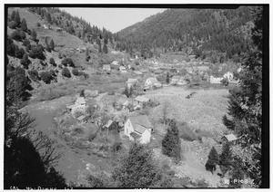
The North Yuba at Downieville, c. 1934
|
|

Map of the Yuba River watershed, including the North Yuba River
|
|
| Country | United States |
| State | California |
| Physical characteristics | |
| Main source | Yuba Pass Near State Route 49, Sierra Nevada 7,018 ft (2,139 m) 39°37′03″N 120°29′53″W / 39.61750°N 120.49806°W |
| River mouth | Yuba River West of North San Juan, Yuba County 1,129 ft (344 m) 39°22′07″N 121°08′11″W / 39.36861°N 121.13639°W |
| Length | 61 mi (98 km) |
| Basin features | |
| Basin size | 489 sq mi (1,270 km2) |
The North Yuba River (also called the North Fork Yuba River) is an important river in northern California, United States. It is the main branch that flows into the larger Yuba River. This river is about 61 miles (98 kilometers) long. It starts high up in the Sierra Nevada mountains and flows west. It eventually reaches the lower hills between the mountains and the Sacramento Valley.
Contents
Journey of the North Yuba River
The North Yuba River begins its journey in the high Sierra Crest mountains. This starting point is about 8 miles (13 km) northwest of a town called Sierraville. The river starts flowing through peaceful meadows.
River's Path and Turns
After the meadows, the river turns south and enters a deep, narrow valley called a gorge. Then, it turns west again. California State Route 49 follows alongside the river for a long part of its journey. This road gives travelers great views of the river.
Tributaries and the Dam
As the North Yuba River flows, it gets water from four main smaller rivers or streams. These are called tributaries. They are the Downie River, Goodyears Creek, Canyon Creek, and Slate Creek. All of these join the North Yuba from its right side.
The river then makes a sharp turn south. Here, it flows into the New Bullards Bar Reservoir. This reservoir is a large lake formed by the New Bullards Bar Dam. The dam is located just before the North Yuba River reaches its end.
Where the River Ends
Right after the North Yuba River leaves the area of the New Bullards Bar Dam, it meets another river. It empties into the Middle Yuba River. When these two rivers join, they officially form the main Yuba River.
