Middle Yuba River facts for kids
Quick facts for kids Middle Yuba River |
|
|---|---|

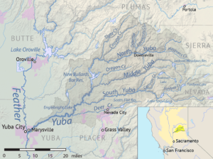
Map of the Yuba River watershed, including the Middle Yuba
|
|
| Country | United States |
| State | California |
| Physical characteristics | |
| Main source | Sierra Nevada Tahoe National Forest, Nevada County 7,320 ft (2,230 m) 39°25′24″N 120°29′05″W / 39.42333°N 120.48472°W |
| River mouth | Yuba River North San Juan, Nevada/Yuba County 1,129 ft (344 m) 39°22′07″N 121°08′11″W / 39.36861°N 121.13639°W |
| Length | 55.4 mi (89.2 km) |
| Basin features | |
| Basin size | 198 sq mi (510 km2) |
The Middle Yuba River is one of the three main branches of the Yuba River in Northern California, United States. It starts high up in the Sierra Nevada mountains. The river then flows west through deep valleys. It joins the North Yuba River near a place called North San Juan.
When the Middle Yuba and North Yuba rivers meet, they form the main Yuba River. This larger river then continues west to join the Feather River. The Middle Yuba River also forms part of the boundary between Nevada County and Sierra County. It flows through a wild and rugged area of the Tahoe National Forest.
Contents
How the River Helps Make Electricity
The Middle Yuba River is very important for making hydroelectricity. This is clean energy made from moving water. The river has several dams and diversions that help with this. These structures change the river's flow. This means the river doesn't flow as strongly as it used to, except when there's a lot of rain.
Jackson Meadows Dam and Reservoir
Near where the river begins, you'll find the Jackson Meadows Dam. This dam is part of a bigger system called the Yuba–Bear Hydroelectric Project. Water from here is sent to other rivers, like the South Yuba and Bear rivers.
Jackson Meadows Reservoir is a popular spot for outdoor fun. Each year, about 10,000 pounds of rainbow trout are added to the reservoir. This makes it a great place for fishing!
Our House Dam and Power Generation
Further downstream, there's another dam called Our House Dam. This dam sends water through long tunnels. The water then goes to New Bullards Bar Reservoir on the North Yuba River. Water is also taken from Oregon Creek, which flows into the Middle Yuba.
All this water helps create even more power. It flows to the New Colgate Powerhouse. This powerhouse is about 4.7 miles (7.6 km) downstream from where the North and Middle Yuba rivers meet.
The River's Gold Rush History
The Middle Yuba River played a big part in the California Gold Rush. This was a time when many people came to California looking for gold. The river was a major site for mining.
Miners used a method called hydraulic mining. This involved using powerful jets of water to wash away hillsides. While it helped find gold, it also washed huge amounts of dirt and rocks into the river. This made the river very muddy.
To stop this debris from flowing further downstream, the Englebright Dam was built in 1941. It was constructed on the Yuba River, below where the Middle Yuba joins it. The dam helped trap all the extra sediment.
Future of the River's Flow
In 2008, studies were done on the Middle Yuba River. These studies looked at how much water should be released from the dams. The goal was to find the best water levels for whitewater boating.
These studies might help bring back some of the river's natural flow. This would be good for the river's health and for recreation. Currently, only a small amount of water is released from Milton Dam. This is much less than how the river flowed naturally before the dams were built.
 | Aaron Henry |
 | T. R. M. Howard |
 | Jesse Jackson |

