
Honey Lake facts for kids
Quick facts for kids Honey Lake |
|
|---|---|

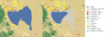
Landsat 7 image of Honey Lake
|
|

Honey Lake
Location in California

Honey Lake
Location in the United States
|
|
| Location | Great Basin, Lassen County, California, United States |
| Coordinates | 40°15′N 120°21′W / 40.250°N 120.350°W |
| Primary inflows | Susan River |
| Basin countries | United States |
| Surface area | 86 sq mi (220 km2) |
| Water volume | 120,000 acre-feet (150,000,000 m3) |
| Settlements | Susanville (20 mi SE) |
Honey Lake is a special kind of lake in northeastern California. It's located near the border with Nevada. This lake is called an "endorheic" lake. This means water flows into it, but it doesn't flow out to the ocean.
In summer, the lake often shrinks a lot because the sun makes the water evaporate. It can become a dry, salty area called an "alkali flat." Most years, Honey Lake dries up almost completely.
People enjoy many activities at Honey Lake. These include bird watching, picnicking, hiking, and camping. You can also go warm-water fishing and waterfowl hunting here. The lake is part of a larger water system. This system includes the Honey Lake and Eagle Lake areas.
History of Honey Lake

Honey Lake got its name from something sweet! Tiny insects called aphids used to be very common in the area. They produced a sugary liquid called honeydew. This gave the lake its unique name.
Long ago, during the Pleistocene Ice Age, Honey Lake was much bigger. It was part of a huge ancient lake called Lake Lahontan. This giant lake covered much of western Nevada. Honey Lake was connected to it through two passes.
Later, before World War II, Honey Lake was used for testing bombs. It was also used for getting rid of old explosives. This continued through the war and into the mid-1950s.
Honey Lake Wildlife Area
The Honey Lake Wildlife Area (HLWA) is a protected area. It covers about 7,667 acres. This area is a wetland located where the Susan River flows into Honey Lake. It's a great place for many different bird species.
You can also find mammals like deer and pronghorn here. There are also some warm-water fish in Honey Lake. The state used to sell special permits for hunting waterfowl in this area.
Importance for Birds
The Honey Lake Wildlife Area was first created to help waterfowl nest and raise their young. This is still a very important job for the area. During busy migration times, many birds visit. You might see as many as 30,000 snow and Canada geese. Also, up to 20,000 ducks have been seen daily.
In winter, you can spot several bald eagles at the HLWA. In spring, you might see threatened sandhill cranes. Other special birds like the white-faced ibis and bank swallow also live here. You can see Ring-necked pheasants and California quail all year round.
Images for kids
-
Honey Lake extent in 2001 and 2011. Data from USGS National Land Cover Dataset
