Arbuckle, California facts for kids
Quick facts for kids
Arbuckle, California
|
|
|---|---|

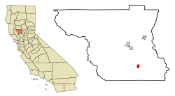
Location in Colusa County and the U.S. state of California
|
|
| Country | United States |
| State | California |
| County | Colusa |
| Area | |
| • Total | 1.76 sq mi (4.56 km2) |
| • Land | 1.76 sq mi (4.56 km2) |
| • Water | 0.00 sq mi (0.00 km2) 0% |
| Elevation | 141 ft (43 m) |
| Population
(2020)
|
|
| • Total | 3,484 |
| • Density | 1,978.42/sq mi (764.05/km2) |
| Time zone | UTC-8 (Pacific (PST)) |
| • Summer (DST) | UTC-7 (PDT) |
| ZIP code |
95912
|
| Area code(s) | 530 |
| FIPS code | 06-02420 |
| GNIS feature IDs | 1657943, 2407755 |
| Website | https://www.countyofcolusa.org/index.aspx?NID=217 |
Arbuckle is a small community located in Colusa County, California, United States. It is known as a census-designated place (CDP). This means it's a special area defined by the U.S. Census Bureau for collecting population data.
In 2020, about 3,484 people lived in Arbuckle. This was an increase from 3,028 people in 2010. Arbuckle is in the southern part of Colusa County. It is about 20 miles (32 km) southwest of the city of Colusa, which is the county seat.
The town has many single-family homes and some apartment buildings. You can also find mobile homes and local businesses. The land around Arbuckle is mostly used for agriculture. Farmers grow annual crops and almonds in orchards. You might see almond hullers nearby, which are machines that remove the outer shells from almonds. Interstate 5 and Old Highway 99 West run next to Arbuckle, making it easy to get around the region.
History of Arbuckle
Arbuckle was founded thanks to Tacitus R. Arbuckle. He started a ranch here in 1866. Later, in 1875, the railroad came through the area. The town was then officially created and named after Arbuckle, as it was built on his land. A post office was set up in Arbuckle the very next year, in 1876.
Geography and Land
Two important streams flow through the Arbuckle area: Salt Creek and Elk Creek. Salt Creek flows north, then turns east, where it meets Elk Creek. Both of these streams then join Sand Creek about half a mile northeast of the town. From there, they flow northeast. Salt Creek can sometimes flood when there is a lot of rain.
Scientists have found that the town of Arbuckle has slowly sunk over time. Between 2008 and 2017, the town sank about 2.14 feet (0.65 m). This was reported by the California Department of Water Resources. This sinking happens because of something called groundwater-related subsidence. It means that when water is taken out of underground water sources (aquifers), the soil above can collapse and sink. A study of over 300 places in the Sacramento Valley showed that Arbuckle had sunk more than any other area in the study.
Population and People
In 2010, the population of Arbuckle was 3,028 people. Most of the people lived in homes, not in group living situations.
The community is made up of people from many different backgrounds. In 2010, about 57.7% of the people were White. About 37.1% were from other races. Many people in Arbuckle, about 69.9%, were of Hispanic or Latino background.
The population includes people of all ages. In 2010, about 32.4% of the people were under 18 years old. About 7.6% were 65 years or older. The average age in Arbuckle was 28.3 years.
Notable People
- Frederick C. Weyand (1916-2010) was a general in the United States Army. He served as the 28th Chief of Staff of the United States Army from 1972 to 1974.
See Also
 In Spanish: Arbuckle para niños
 | James Van Der Zee |
 | Alma Thomas |
 | Ellis Wilson |
 | Margaret Taylor-Burroughs |


