
Cottonwood Creek (Sacramento River tributary) facts for kids
Quick facts for kids Cottonwood Creek |
|
|---|---|

Cottonwood Creek
|
|

Location of the mouth of Cottonwood Creek in California
|
|
| Country | United States |
| State | California |
| Physical characteristics | |
| Main source | Confluence of North and Middle Forks near Janesville 541 ft (165 m) 40°23′41″N 122°31′33″W / 40.39472°N 122.52583°W |
| River mouth | Sacramento River about 5 miles (8.0 km) east of Cottonwood 341 ft (104 m) 40°22′40″N 122°11′58″W / 40.37778°N 122.19944°W |
| Length | 68 mi (109 km) |
| Basin features | |
| Basin size | 938 sq mi (2,430 km2) |
| Tributaries |
|
Cottonwood Creek is a large stream in Northern California. It flows into the Sacramento River. The creek is about 68 miles (109 km) long. It drains a big area of land. This area stretches from the Coast Ranges mountains. It then crosses the northwestern Sacramento Valley. Finally, it empties into the Sacramento River near the town of Cottonwood.
For its whole length, Cottonwood Creek forms the border between Shasta and Tehama counties. It is special because it is the largest tributary of the Sacramento River that has no dams. This makes it very important for fish like Chinook salmon and steelhead. These fish swim up the creek to lay their eggs.
Contents
Where Does Cottonwood Creek Flow?
Cottonwood Creek starts from three main branches. These are the North, Middle, and South Forks. Many smaller streams also feed into it.
North Fork's Journey
The North Fork begins high up near Shasta Bally. This peak is in the southern Klamath Mountains. It flows southwest through a small lake called Rainbow Lake. After the lake, it turns south. It then flows east, coming out of the mountains near Ono. From there, it heads southeast through the Klamath foothills.
Middle Fork's Path
The Middle Fork starts in the Shasta–Trinity National Forest. It flows east to Platina. Here, it briefly turns north before heading east again. It cuts a deep canyon. This fork then joins Beegum Creek, its biggest side stream. Below Beegum Creek, it becomes the border between Shasta and Tehama counties.
Joining of the Forks
The North and Middle Forks meet near Janesville. This is where the main part of Cottonwood Creek begins. This main stream continues to mark the county line.
South Fork's Contribution
The South Fork is the largest of the three branches. It drains a big part of the southern area. It starts on North Yolla Bolly Mountain. It flows east through the foothills. It then joins the Cold Fork, its main side stream. After that, it is joined by Dry Creek. Finally, it flows into the main Cottonwood Creek. This happens about 2 miles (3.2 km) west of Cottonwood.
The Main Creek's Flow
The main part of Cottonwood Creek is about 25 miles (40 km) long. It flows mostly east through a wide valley. It picks up Antelope and Dry Creeks from the north. Then, it gets Little Dry Creek from the south. The Anderson Cottonwood Canal crosses the creek using an inverted siphon. This is like an upside-down U-shaped pipe that carries water under the creek.
The South Fork joins about halfway to the Sacramento River. This almost doubles the amount of water in the creek. Near the town of Cottonwood, Interstate 5 and the Southern Pacific Railroad cross the creek. Soon after, Patterson Creek joins. This is the last stream before Cottonwood Creek flows into the Sacramento River. This meeting point is about 25 miles (40 km) downstream of Redding.
What is the Cottonwood Creek Area Like?
The Cottonwood Creek area is shaped like a fan. It is in the northwestern part of the Sacramento Valley. Mountains surround it. The Klamath Mountains are to the north. The Yolla Bolly Mountains are to the west.
Mountains and Forests
The Klamath Mountains reach heights of about 4,000 to 5,000 feet (1,200 to 1,500 m). The Yolla Bolly Mountains have peaks over 7,000 feet (2,100 m). The area has two main plant zones. The foothills have chaparral (shrubs), blue oak trees, and grasses. The mountains have mixed forests. These include Douglas fir and gray pine trees. The upper parts of the creek are steep and fast-flowing. They have rocky beds. These mountain areas also have logging businesses and large national forests.
Valleys and Farmland
The lower part of the area is hilly. It has large areas of rangeland (land for grazing animals). Cottonwood Creek forms a wide, flat valley. This valley is mostly used for farming. Some gravel is also mined here. In the past, this area was mostly wetlands (swampy land). It often flooded from the creek and the Sacramento River. Some natural areas along the creek, called riparian zones, still remain. These are important for wildlife.
The area is not very crowded. The biggest town is Cottonwood. However, nearby Redding is growing. This means more people are moving closer to the Cottonwood Creek area.
Neighboring Waterways
To the north, Cottonwood Creek's area borders other creeks. These include Clear Creek and Anderson Creek. Both flow into the Sacramento River. Reading Creek flows into the Trinity River. To the west, it borders the South Fork Trinity River and Hayfork Creek. To the southwest, it briefly borders the Middle Fork Eel River. This river flows to the Pacific Ocean. The Cottonwood, Trinity, and Eel watersheds meet at a special spot called Skylight Ridge. To the south, it borders Thomes Creek, another big stream that flows into the Sacramento River.
Water Levels and Floods
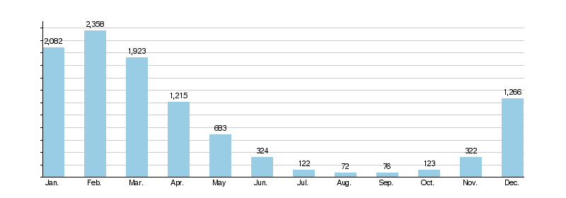
The Cottonwood Creek area gets about 36 inches (910 mm) of rain each year. The mountains get more rain (60 inches (1,500 mm)). The lowlands get less (25 inches (640 mm)). Most of the rain falls between December and April. This means the "creek" can become a large river in winter and spring. But in summer and fall, it can shrink to a small trickle.
Because of the mountains and seasonal rain, Cottonwood Creek often has flash floods. The average amount of water flowing in the creek is about 860 cubic feet per second (24 m3/s). In summer, it's only 50 to 100 cubic feet per second (1.4 to 2.8 m3/s). But in winter, it can easily reach thousands of cubic feet per second.
Cottonwood Creek monthly water flow at Cottonwood (cfs)
A Look Back: History of Cottonwood Creek
The Wintu people once lived in the Cottonwood Creek valley. They spent winters in the lowlands. In summer, they moved to the mountains to find food. The Wintu groups in this area were called the Nomlaki. They lived by hunting and gathering. They did not build many permanent towns. Before Europeans arrived, there were likely over 2,000 Nomlaki people.
How the Creek Got its Name
In 1846, Captain John C. Frémont named the creek. He was exploring the area with his soldiers. Frémont saw many cottonwood trees along the creek's sandy bed. He noted that the water was about 20 yards (18 m) wide then.
Early Settlers and Gold
In 1844, Pierson B. Reading received a large piece of land. This was from the governor of Alta California. Reading settled north of where Cottonwood Creek meets the Sacramento River. He is considered the first non-Native American settler in the area. The city of Redding was named after Fort Redding. This fort was named after Pierson Reading.
In March 1848, Reading found gold on his land. This happened shortly after James Marshall found gold at Sutter's Mill. That discovery started the famous California Gold Rush. Finding gold brought many miners and settlers to the Cottonwood Creek area.
Growth of Towns
The first lasting American settlement on Cottonwood Creek began around 1849. It was a trading post for miners. The original settlement was on the south side of the creek. But later, the town of Cottonwood grew on the north side. Smaller towns like Janesville and Igo also started as mining towns. In 1852, the first post office opened in the Cottonwood area. In 1856, Tehama County was created. Its border with Shasta County was drawn along Cottonwood Creek.
Treaties and Mining Changes
In 1851, the Wintu signed a treaty. They gave up most of their land to the U.S. Government. In return, they were supposed to get reservation lands. However, California did not approve this treaty. The state wanted more land for American settlers. So, the treaty was never officially accepted. Native peoples were slowly forced off their lands.
Cottonwood Creek did not have huge gold discoveries. But some hydraulic mining (using water to wash away dirt for gold) happened there. This type of mining stopped in Northern California. It caused too much waste and dirt in the rivers. This hurt water quality and made it hard for boats to travel.
In 1872, the first train station in Shasta County was built in Cottonwood. This was when the Southern Pacific Railroad extended north. The area then became a major shipping point. Lumber and livestock from Shasta County were sent from here.
Why Not Build Dams on Cottonwood Creek?
Since the 1940s, people have thought about building dams on Cottonwood Creek. Dams could help control floods. They could also provide water for the California State Water Project. These dams could store a lot of water.
The Importance of No Dams
Cottonwood Creek is the largest tributary of the Sacramento River without dams. This means a lot of water flows into the Pacific Ocean during winter floods. Sometimes, this causes flood damage in towns along the Sacramento River. Several dams have been suggested for Cottonwood Creek and its branches.
Proposed Dam Projects
Some of the proposed dams included:
- Dutch Gulch Dam on the main creek. It would be 247 feet (75 m) high. It could hold a lot of water.
- Tehama Dam on the South Fork. It would be 215 feet (66 m) high. It could hold a lot of water.
- Dippingvat Dam on the South Fork. It would be 251 feet (77 m) high.
- Schoenfield Dam on Red Bank Creek. It would be 300 feet (91 m) high.
These dam ideas have been brought up many times. But they were always rejected. Local people did not want them. Also, there were worries that dams would block the salmon and steelhead from swimming upstream to lay eggs.
However, some studies suggested dams could help fish. They could release cold water in dry seasons. This would improve fish habitats. It would also make the water better in the Sacramento River and the Sacramento–San Joaquin River Delta. This delta is a key water source for millions of Californians.
There is one small dam on the North Fork. It is called Musselbeck Dam. It was built in 1920. It creates Rainbow Lake. This dam provides water for small towns like Igo and Ono.
Wildlife and Nature in Cottonwood Creek
The Mouth of Cottonwood Creek Wildlife Area protects nature. It is where Cottonwood Creek meets the Sacramento River. This area covers about 1,100 acres (450 ha) of riparian (riverbank) and wetland habitats. It has two parts: the Balls Ferry and Cottonwood Creek Wetlands Units.
Plants and Animals
Many trees grow here. These include cottonwood, Oregon ash, and willow trees. The area is home to animals like ring-tailed cats, river otters, and beavers. Many birds also live here. These include Swainson's hawks and bald eagles. People can hunt here, but there are no staff or buildings.
Fish and Their Challenges
Cottonwood Creek and its year-round streams offer about 130 miles (210 km) of habitat for fish. These include spring and fall run Chinook salmon and steelhead (rainbow trout). These fish are called anadromous fish. They live in the ocean but swim up rivers to lay eggs.
However, gold mining in the 1800s caused problems. Logging and ranching also added to this. The creek has too much sedimentation (dirt and sand settling). This is bad for the fish. The spring Chinook salmon have been hit hard. Only one or two fish returned each year between 2011 and 2014. But in 2014, 1,940 fall Chinook returned. The steelhead population is not tracked as closely. But it is listed as threatened, just like the spring Chinook.
Helping the Creek and Fish
State and federal groups are working to restore the creek. They remove things that block fish from swimming upstream. They also close old logging roads. They install culverts (pipes under roads) to stop dirt from washing into the creek. In September 2014, the Hammer Dam on the South Fork was removed. This opened up 5 miles (8.0 km) of habitat for spring-run Chinook and steelhead. As of 2009, the U.S. Fish and Wildlife Service has given $10 million for these restoration projects.
