
Hayfork Creek facts for kids
Quick facts for kids Hayfork Creek |
|
|---|---|
 |
|

Map of the South Fork Trinity River basin, showing Hayfork Creek to the right of the main stem.
|
|
| Other name(s) | Hayfork River, Hayfork Branch, Hay Fork Trinity River |
| Country | United States |
| State | California |
| Cities | Hayfork, Hyampom |
| Physical characteristics | |
| Main source | Brushy Mountain (Shasta County, California) Shasta-Trinity National Forest 5,052 ft (1,540 m) 40°17′36″N 123°04′22″W / 40.29333°N 123.07278°W |
| River mouth | South Fork Trinity River Hyampom 1,276 ft (389 m) 40°36′51″N 123°27′06″W / 40.61417°N 123.45167°W |
| Length | 50 mi (80 km), north then west |
| Basin features | |
| Basin size | 379 sq mi (980 km2) |
| Tributaries |
|
Hayfork Creek is a river in Northern California, United States. It flows into the South Fork Trinity River. At over 50 miles (80 km) long, it is the longest river that flows into the South Fork Trinity. It is also one of the southernmost rivers in the Klamath Basin.
The creek winds through steep, narrow valleys in the Klamath Mountains. However, it also passes through the Hayfork and Hyampom Valleys. These valleys are the main farming areas in Trinity County.
The land around Hayfork Creek was first home to the Wintu people. Humans have lived in this area for more than 5,000 years. The first Europeans arrived in the late 1820s. But the area really grew in the 1850s during the California Gold Rush. The rich soil and good weather in the river valley made it the best farming area in the county.
Logging started in the 1920s. By the 1940s, logging began to harm the environment of the river. This included the once-large populations of Coho salmon and steelhead trout.
Contents
Journey of Hayfork Creek
Hayfork Creek starts on the west side of Brushy Mountain. This is about 7 miles (11 km) south of a small place called Wildwood.
Flowing North and West
The creek generally flows north through a deep, forested valley. This area is part of the Shasta-Trinity National Forest. It receives water from the East Fork of Hayfork Creek. About 5 miles (8 km) downstream, it enters the Hayfork Valley. This is a large farming area in the middle of the Klamath Mountains. Here, Summit and Big Creeks join from the right. Salt Creek joins from the left. The creek also passes State Route 3 and the small town of Hayfork.
After leaving the valley, the river turns northwest. It flows through a steep gorge, with whitewater rapids and large rocks. At the Miners Creek meeting point, Hayfork Creek turns west. Soon after, Corral Creek joins it. About 1 mile (1.6 km) before its end, the river flows out of the mountains into the town of Hyampom. It then joins the South Fork of the Trinity River just south of Hyampom. This is about 30 miles (48 km) upstream from where the larger Trinity River meets the South Fork.
Water Flow Measurements
The United States Geological Survey (USGS) measured the water flow of Hayfork Creek at Hyampom. They collected data from 1954 to 1974. During these 20 years, the average water flow at the mouth was 552 cubic feet per second (15.6 m³/s). The highest flow was 29,400 cubic feet per second (830 m³/s) in December 1964. The lowest average monthly flow was 19.1 cubic feet per second (0.54 m³/s) in September 1960.
Another measuring station was at Hayfork from 1956 to 1976. The average yearly flow there was 119 cubic feet per second (3.4 m³/s) between 1956 and 1965. The highest flow was 7,520 cubic feet per second (213 m³/s) in December 1964. The lowest average monthly flow was 3 cubic feet per second (0.085 m³/s) in August 1959.
Hayfork Creek Watershed
The Hayfork Creek watershed is a mountainous and remote area. It covers 379 square miles (980 km²) in southern Trinity County. Most of the area is covered by the Klamath Mountains. But it also has some of Trinity County's best farmland in the Hayfork and Hyampom Valleys.
Land and Elevation
The land in the watershed ranges from 6,400 feet (2,000 m) high at Chanchelulla Peak. This is the highest point in the basin. It goes down to 1,276 feet (389 m) at the river's mouth. About 78.6% of the watershed (298 square miles or 770 km²) is public land. Most of this is owned by the United States Forest Service. The other 21.4% is private land. This land is mainly used for cattle ranching and farming.
The Hayfork Creek watershed is separated from other river valleys by mountain ridges. To the west, it borders the South Fork Trinity River. To the northwest is the main Trinity River valley. In the east, a long ridge separates the Hayfork basin from the Sacramento Valley. This ridge is near the start of Cottonwood Creek, which flows into the Sacramento River.
The mountains generally get lower from east to west. They are over 6,000 feet (1,800 m) high in the east. They are about 4,500 feet (1,400 m) high near the South Fork Trinity River. The creek itself starts at over 5,000 feet (1,500 m) high. The Hayfork Valley is at an elevation of 2,418 feet (737 m).
Plants and Challenges
The watershed has many different types of land. It ranges from cool, high-altitude areas in the Chanchellula Wilderness. It goes down to hot, dry areas in the lower river valley. The main type of plant life is a mix of conifer and hardwood forests. Common trees include Douglas-fir, ponderosa pine, and California black oak. Along the river, you can find bigleaf maple and white alder.
The Hayfork Valley mostly has oak and grey pine forests and grasslands. But much of this has been changed for homes and farms. In the valley, the creek faces problems like high water temperatures. It also has pollution from ranching along its banks. Water is also taken from smaller streams that flow into it. In 2014, during a drought, parts of the creek even dried up.
The biggest water diversion is from Big Creek, north of Hayfork. This water goes to Big Creek Ranch and Ewing Reservoir. Ewing Reservoir is Hayfork's water supply. The water district can take water from December 1st to June 1st each winter. They then use this water slowly throughout the summer.
Towns and Population
The largest town along the creek is Hayfork, with about 2,368 people. Hyampom, with 241 people, is the only other official settlement. However, only about a quarter of Hyampom's people live in the Hayfork Creek watershed. Other small settlements are Peanut (73 people) and Wildwood (64 people).
Hayfork is the second largest town in Trinity County. It is central to the Hayfork Valley, which is the main farming area in the county. The total human population of the watershed is about 2,750-3,000 people. This means there are about 7.3-7.9 people per square mile. If you only count people outside of Hayfork, it's about 1-1.7 people per square mile.
Geology of the Area
Hayfork Creek flows through the Klamath Mountains. These mountains were formed when different pieces of Earth's crust, called terranes, crashed into the North American plate. This collision caused the land to buckle and rise, forming the mountain ranges of northwestern California over time.
Hayfork Creek crosses the western part of the Hayfork Terrane. This land was formed about 165 million years ago. It collided with the North American Plate between 140 and 120 million years ago. The Klamath Mountains first rose about 59 million years ago. They have continued to change through erosion and mountain-building events. The last major mountain-building period was about 1.6 million years ago. Scientists believe the creek's path was set before the mountains formed. As the mountains rose, the creek cut canyons and valleys into the rock, keeping its original path.
The Hayfork Valley is a basin filled with sediments. These sediments are at least 300 feet (91 m) deep. They were brought by Hayfork, Carr, Barker, Big, Salt, and other streams. About 30 feet (9 m) of this sediment is from the Holocene period, less than 12,000 years ago. The valley sits on top of the Hayfork Valley Groundwater Basin. Water in this basin is found from 10 to 35 feet (3 to 11 m) below the surface.
History of Hayfork Creek
The Wintu Native American tribe lived along Hayfork Creek. Specifically, the Nor-El-Muk or Hayfork Wintu, one of six main groups of the tribe. Their land stretched through the highlands and mountains of the upper Hayfork Creek basin. This area bordered the Hayfork Valley. Old sites with spearheads and arrowheads have been found as far downstream as Hyampom.
The Wintu people had permanent winter camps along streams. In spring and summer, they traveled to higher areas to hunt. A very important food for them was salmon, which were plentiful in the rivers. Other important foods included acorns, berries, and small animals.
Early Explorers and Settlers
The first outsider to see Hayfork Creek was a fur trapper named Jedediah Smith in 1828. He was leading a trip from northern California into Oregon. His group traveled up Hayfork Creek, the South Fork Trinity River, and the Trinity and Klamath Rivers. They eventually reached the far northern Pacific coast of California. However, they did not stay in the area for long. The path Smith and his men took along lower Hayfork Creek later became a trade route. This route connected the Central Valley with coastal Oregon.
After the California Gold Rush began in 1848, Americans started to settle the Hayfork Valley. Because of its rich water, mild weather, and fertile soil, it quickly became the most productive farming area in Trinity County. It was known as the "breadbasket" of the county. Miners also looked for gold along the upper part of the creek and its smaller streams.
In 1851, the town of Hayfork was founded. It was first called Kingsberrys. The town grew quickly because of the valley's improving economy. By 1860, its population reached 1,200 people. The Hyampom Valley, though smaller, had similar good qualities. The first lasting European settlements there were built in the 1860s.
Bridge Gulch Incident
In 1852, a settler from Weaverville was reportedly killed by Native Americans. His cattle were also stolen. After his body was found, a search party tracked the Native Americans to their camp. This camp was at the meeting point of Bridge Gulch and Hayfork Creek. Bridge Gulch is known for a natural bridge. About 70 white settlers from Weaverville went to the camp. They killed 153 of the 158 Native Americans. This event became known as the Bridge Gulch massacre.
Ecology of Hayfork Creek
In the past, Hayfork Creek was a very good place for steelhead trout and salmon. These fish were once very common in the Trinity River basin. However, farming runoff since the late 1800s has harmed the creek's ecosystem downstream of Hayfork. This area is the largest farming region in the watershed.
Environmental Concerns
Logging and clearing land for ranching have caused more dirt and mud to wash into the stream. This makes the water cloudy and puts fish in danger. The upper part of the creek is polluted by acid from old mines. The Kelly Mine on McCovey Gulch, for example, releases a lot of chromium and arsenic.
In recent dry summers, the water temperature near the mouth of the creek has risen above 85 °F (29 °C). This temperature can kill fish. Records show many female salmon die. There are also repeated fish kills. These are likely caused by high temperatures and cloudy water. The cloudy water comes from pollution and dirt washing down from farms and developed areas.
One of the biggest problems for the watershed is the loss of forests. While more trees have been lost in the South Fork Trinity valley, the amount of dirt in Hayfork Creek has been rising since 1944. This dirt is above safe levels for the environment. The rocks under Hayfork Creek are usually stable. But erosion has increased because of new roads being built.
Wildlife and Birds
Several endangered or threatened animals live in the watershed. These include the Northern spotted owl and the peregrine falcon. The Hayfork Creek valley is also an important path for birds that migrate. These birds travel between the Pacific coast and the Sacramento Valley.
Fun Activities at Hayfork Creek
Hayfork Creek is well-known in Trinity County for recreational gold mining. Some of the best places to find gold in Northern California are said to be along Hayfork Creek. These spots are upstream of the Hayfork Valley and below Wildwood. The creek bed's geology is like a "natural gold trap." People have found up to 60 ounces of gold in one day there recently.
For experienced kayakers and rafters, the upper and lower parts of Hayfork Creek have many rapids. These rapids range from Class III to V in difficulty. Especially in the lower part of the creek, large rocks and waterfalls mean you might have to carry your boat. The river's flow changes a lot because it has no dams and only a few diversions. The water level can go from 50 cubic feet per second (1.4 m³/s) to 10,000 cubic feet per second (280 m³/s) in a year. Boating is safest when the water flow is between 400 to 2,000 cubic feet per second (11 to 57 m³/s).
Images for kids
-
-
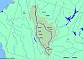
Map of the South Fork Trinity River basin, showing Hayfork Creek to the right of the main stem.
