
South Fork Trinity River facts for kids
Quick facts for kids South Fork Trinity River |
|
|---|---|
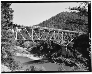
South Fork Trinity River at the Highway 299 bridge
|
|

Map of the Trinity River watershed with the South Fork extending south from the mainstem; watershed highlighted in yellow
|
|
| Country | United States |
| State | California |
| Region | Klamath Mountains, Humboldt County, Trinity County |
| Physical characteristics | |
| Main source | Unnamed spring North Yolla Bolly Mountain, Trinity County 5,921 ft (1,805 m) 40°09′24″N 122°59′18″W / 40.15667°N 122.98833°W |
| River mouth | Trinity River Salyer, Trinity County 446 ft (136 m) 40°53′23″N 122°36′08″W / 40.88972°N 122.60222°W |
| Length | 92 mi (148 km) |
| Basin features | |
| Basin size | 980 sq mi (2,500 km2) |
| Tributaries |
|
The South Fork Trinity River is the biggest river that flows into the Trinity River. It is located in northern California, a state in the United States. This river is part of the larger Klamath River system.
The South Fork Trinity River flows for about 92 miles (148 km). It starts in the Klamath Mountains and flows mostly northwest. It passes through Humboldt and Trinity Counties. Finally, it joins the Trinity River near a town called Salyer. Its main smaller rivers that join it are Hayfork Creek and the East Branch South Fork Trinity River.
What's special about this river? It has no big dams or diversions. This means its water flows freely. Because of this, the entire river is protected as a Wild and Scenic River. This protection helps keep the river natural and healthy.
The South Fork Trinity River is one of California's largest undammed rivers. It drains a big area of 980 square miles (2,500 km2). This area is wild and remote. It has important habitats for many endangered animals and rare plants. Long ago, the South Fork was famous for its huge numbers of anadromous fish (fish that swim from the ocean to fresh water to lay eggs). It also had thick, old-growth forests.
In the mid-1900s, the river was badly damaged by big floods. Mining, logging, and ranching made the erosion worse. Even today, the South Fork is still recovering from these past problems.
Contents
- River's Journey: Where Does the South Fork Trinity River Flow?
- River Crossings: Bridges Over the South Fork Trinity River
- River's Home: Understanding the South Fork Trinity Watershed
- River Flow: How Much Water is in the South Fork Trinity River?
- River's Past: A Look at South Fork Trinity River History
- Animals and Plants: Life in the South Fork Trinity River
- Images for kids
River's Journey: Where Does the South Fork Trinity River Flow?
The South Fork Trinity River starts as a small spring. This spring is on the west side of Brooks Ridge, near North Yolla Bolly Mountain. It begins at about 4,460 feet (1,360 m) above sea level.
From its source, the river flows west for a short distance. Then it turns north. Many small streams join it, flowing from steep, forested valleys. About 4 miles (6.4 km) from its start, the river flows under the Humboldt Trail. After that, Shell Mountain Creek joins it from the west.
A bit further downstream, the East Branch South Fork Trinity River joins from the east. This branch is about 10-mile (16 km) long. Soon after, Happy Camp Creek joins from the west, and Smoky Creek joins from the east.
Passing Through Towns and Valleys
The river then flows past Forest Glen. Rattlesnake Creek joins it from the east. The river also flows under California State Route 36. Here, the South Fork runs next to the Mad River, with a 2,000-foot (610 m) hill separating them. Below State Route 36, Butter Creek and Indian Valley Creek join the river, both from the east.
Next, the river enters the wide Hyampom Valley. It flows past the town of Hyampom. Here, its biggest tributary, Hayfork Creek, joins it from the east. The river then passes the Hyampom Airport. Pelletreau Creek joins it from the west. In this valley, the river spreads out into many small channels, creating a wide, flat area.
At the north end of the valley, the river enters another canyon. Mingo Creek joins it from the west. The river then turns sharply east, and then sharply north again. Madden Creek joins it from the west. Finally, the river flows under California State Route 299. Right after this bridge, the South Fork flows north into the Trinity River.
River Crossings: Bridges Over the South Fork Trinity River
Many bridges cross the South Fork Trinity River from its source to its end. Some are footbridges, meaning only people can cross them. Here are some of the crossings:
- Wild-Mad Road: This crossing is at an elevation of 2,915 feet.
- Silver Creek Ranch I and II: These might be bridges for pipes or cables. They are at 2,475 feet.
- Private Bridge on South Fork Trinity Trail: This is a suspension bridge for ATVs, but not for cars. It's at 2,390 feet.
- Private Bridge to Abandoned Homestead: This suspension bridge might be for pipes, but you can also walk across it. It's at 2,350 feet.
- Scott Flat Footbridge: This suspension bridge is currently closed. It's at 2,325 feet.
- State Route 36: This road crosses the river at 2,275 feet.
- Graham Place Footbridge: A footbridge at 1,800 feet.
- McClellan Place Footbridge: Another footbridge at 1,665 feet.
- Oak Flat Footbridge: A footbridge at 1,430 feet.
- South Fork Road: This road crosses the river at 1,280 feet.
- Mule Bridge: This bridge was almost removed but local people saved it. It's at 950 feet.
- Low-Water Bridge: This bridge was washed out by floods and no longer exists. It was a popular swimming spot. It was at 550 feet.
- Limestairs Footbridge: A footbridge at 545 feet.
- State Route 299: This is the tallest, longest, and widest bridge over the river. It's at 445 feet.
River's Home: Understanding the South Fork Trinity Watershed
The South Fork Trinity River and its smaller streams drain a large area of 980 square miles (2,500 km2). This area is called a watershed. It covers parts of Trinity County and Humboldt County. This watershed makes up about 34 percent of the entire Trinity River watershed.
The Hayfork Creek area alone covers 379 square miles (980 km2). This is 38 percent of the whole South Fork Trinity watershed! Most of the land in the South Fork watershed (79 percent) is public land, like national forests.
The South Fork Trinity watershed has mountains like the Yolla Bolly Mountains and the Klamath Mountains. It has deep canyons and valleys with narrow ridges between them. The South Fork is the longest National Wild and Scenic River in California that has no dams.
Water Quality and Land Use
While the South Fork River itself doesn't have much human development, it gets pollution from Hayfork Creek. The Hayfork Valley has over 52,000 acres (210 km2) of farms and ranches. Sometimes, many fish die in Hayfork Creek, and its water quality can be very bad in the summer.
Logging and building roads have caused problems for the main South Fork River. Cutting down trees on hillsides makes the soil wash away faster. This cloudy water makes it hard for fish like steelhead trout and chinook salmon to live and lay their eggs. These fish used to be very common in the river. Even though logging has mostly stopped in the national forests, the land is still recovering.
Much of the South Fork Trinity River's watershed is covered by national forests. The Shasta-Trinity National Forest covers most of the southern and central parts. The Six Rivers National Forest covers the northern part. Most of the upper South Fork is inside the Shasta-Trinity National Forest. Further downstream, private lands appear, and the river enters Six Rivers National Forest.
River Flow: How Much Water is in the South Fork Trinity River?
The South Fork Trinity River flows into the Trinity River near Salyer. The United States Geological Survey (USGS) measures the river's flow at different points. These points are at Salyer, downstream of Hyampom, at Hyampom (before Hayfork Creek joins), and at Forest Glen.
On average, the river flows at 1,807 cubic feet per second (51.2 m3/s) near its mouth. The biggest flow ever recorded near Salyer was 95,400 cubic feet per second (2,700 m3/s). This happened during a huge flood on December 22, 1964. The lowest flow recorded there was 8,480 cubic feet per second (240 m3/s) on December 31, 1954.
River's Past: A Look at South Fork Trinity River History
For thousands of years, Native American groups like the Tsnungwe, Chimariko, Yuki, and Wintu lived along the South Fork Trinity River. The river was a rich source of food, with huge numbers of salmon swimming upstream each year. Old-growth forests covered most of the area.
In the 1800s, events like the California Gold Rush brought many Europeans and Americans to the region. They came looking for furs and later, gold. A trail used by these newcomers crossed the Yolla Bolly Mountains and led to Hayfork Creek and the South Fork Trinity.
By the 1930s, people were already using hydraulic mining near the river's mouth. This method uses powerful water jets to break down hillsides. In the late 1940s, logging companies began cutting down trees in the South Fork Trinity's watershed. Soon, dirt and debris from these logging areas started to cloud the streams that fed the South Fork.
The Great Flood of 1964
In the Christmas flood of 1964, very heavy rains caused massive amounts of silt and debris to wash from clear-cut lands into the river. This event killed many fish and amphibians. The flood reached its highest point on December 22, with a flow of 95,400 cubic feet per second (2,700 m3/s). People said the South Fork was "a lost cause" and would "never recover" from the damage. Even decades later, the soil washes away much faster than it did before 1964. By the 1970s, the number of fish that swim from the ocean to lay eggs dropped a lot because of all the silt.
In 1947, the Six Rivers National Forest was created. This forest covers part of the northern South Fork Trinity watershed. By 1954, the Shasta–Trinity National Forest was established. This forest covers most of the South Fork Trinity River's watershed, putting nearly 70 percent of the area under federal protection. In 1980, the United States Forest Service created the South Fork National Recreation Trail. This trail runs from Forest Glen to near the river's source.
Animals and Plants: Life in the South Fork Trinity River
Before the 1964 floods, about 3,400 to 10,000 spring chinook salmon would swim up the river each year. After the floods, this number dropped to between 345 and 2,460 before 1990. As the mountainsides slowly recover from logging, salmon numbers are starting to rise again, now averaging 2,000 to 4,000.
Even though the South Fork flows freely to the Klamath and then to the Pacific Ocean, it's still hard for migrating fish to reach it. This is because most of the Trinity River's main water is diverted, and the Klamath River has pollution. Also, a high number of female salmon die, which means fewer baby fish are born. In summer, the river's water can get very warm, over 80 degrees Fahrenheit (27 degrees Celsius). This allows other fish, like green sunfish, to grow and compete with the salmon.
The remaining old-growth forests in the South Fork watershed are very important. They provide homes for several threatened animals, including the northern spotted owl.
Images for kids
-

South Fork Trinity River at the Highway 299 bridge
-
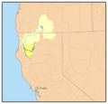
Map of the Trinity River watershed with the South Fork extending south from the mainstem; watershed highlighted in yellow
