
Trinity River (California) facts for kids
Quick facts for kids Trinity River |
|
|---|---|

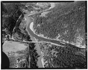
Trinity River near Weaverville
|
|

Map of the Trinity River and Klamath River watersheds. The Trinity River is shown in dark blue, with its watershed highlighted in dark yellow. The South Fork Trinity River extends southward, while the main Trinity River curves east then north.
|
|
| Other name(s) | Hoopa River |
| Country | United States |
| State | California |
| Physical characteristics | |
| Main source | Scott Mountains Trinity County 5,557 ft (1,694 m) 41°19′53″N 122°33′9″W / 41.33139°N 122.55250°W |
| River mouth | Klamath River Weitchpec 190 ft (58 m) 41°11′5″N 123°42′31″W / 41.18472°N 123.70861°W |
| Length | 165 mi (266 km) |
| Basin features | |
| Basin size | 2,936 sq mi (7,600 km2) |
| Tributaries |
|
| Type: | Wild, Scenic, Recreational |
| Designated: | January 19, 1981 |
The Trinity River is a big river in northwestern California, United States. It is the main branch of the Klamath River. The Trinity River flows for 165 miles (266 km) through mountains and hills. Its watershed covers almost 3,000 square miles (7,800 km2) in Trinity and Humboldt Counties.
This river is special because it's part of the National Wild and Scenic Rivers System. This means it's protected for its natural beauty and wildlife. For thousands of years, Native American tribes like the Yurok and Hupa depended on the river. They caught many fish, especially Chinook salmon and steelhead, which swim upriver from the ocean to lay their eggs.
In the mid-1800s, the California Gold Rush brought many gold seekers to the area. Major Pierson B. Reading named the river in 1848. He thought it flowed into the Pacific Ocean at Trinidad Bay, but he was mistaken. The arrival of settlers and miners caused challenges for the Native American tribes. Many people got sick and died from diseases, and there were conflicts. Later, logging, ranching, and mining changed the river's environment and reduced fish populations.
Today, the Trinity River is important for providing water for farms and making electricity. It's also a popular place for fun activities like gold panning, fishing, and whitewater rafting. Since 1964, a dam has created Trinity Lake, one of California's largest man-made lakes. A lot of the river's water is sent to farms in the Central Valley. However, rules were put in place in 1991 to release more water back into the Trinity River to help the fish. Deciding how much water the river gets is still a big discussion, especially when there isn't much rain.
Contents
The Trinity River's Journey
The Trinity River starts high up in the Scott Mountains in Trinity County. It flows south through a deep valley, picking up water from smaller streams. These streams include Bear Creek, Bull Creek, and Cedar Creek.
Where the River Begins
The river then flows into Trinity Lake. This is a large lake made by the Trinity Dam. Many other streams, like Coffee Creek and Stuart Fork, also flow into this lake. Just below Trinity Dam is a smaller dam called Lewiston Dam. This dam sends some of the Trinity River's water through a power plant. This water then goes to the Sacramento River Basin to help water farms in California's Central Valley.
After Lewiston Dam, the Trinity River flows past towns like Lewiston and Douglas City. It then turns west, near Weaverville, the main town in the area. The river continues northwest, joining with other rivers like the North Fork Trinity River. It passes through deep canyons, where Highway 299 follows its path. At Salyer, the South Fork joins, making the river much bigger.
Water Flow and Changes
After the South Fork joins, the Trinity River turns north into Humboldt County. It flows through the Hoopa Valley Reservation, past Willow Creek and Hoopa. Finally, it meets the Klamath River at Weitchpec. This is about 44 miles (71 km) before the Klamath River reaches the Pacific Ocean.
The Trinity River gets most of its water from rain, especially from December to April. Water levels can rise quickly during winter storms. In summer, there's little rain. The river then gets its water from melting snow in the mountains and from underground water. Since the 1960s, sending water to the Central Valley has reduced the river's flow. However, dams must release a certain amount of water to protect fish, so the river has more water in dry seasons than it would naturally.
The United States Geological Survey (USGS) measures the river's flow at different spots. At Hoopa, near the river's end, the average water flow from 1964 to 2013 was 4,849 cubic feet per second (137.3 m3/s). Before the dams were built (1912–1960), the average flow was higher, at 5,618 cubic feet per second (159.1 m3/s). The highest flow ever recorded was 231,000 cubic feet per second (6,500 m3/s) during a huge flood in December 1964. The lowest was 162 cubic feet per second (4.6 m3/s) in October 1931.
The Land Around the River

The Trinity River's watershed is a large area of 2,936 square miles (7,600 km2). It's a rugged, forested part of California's North Coast. The highest point is Sawtooth Peak in the Trinity Alps, at 8,888 feet (2,709 m). The lowest point is where the Trinity meets the Klamath River, at 190 feet (58 m).
Mountains, Forests, and Valleys
Most of the watershed is covered by mountains. There are only a few flat areas, like the Weaverville basin and the Hoopa, Hyampom, and Hayfork Valleys. Hayfork Valley is the biggest farming area in Trinity County. About 80% of the land in the watershed is federal land, managed by the U.S. Forest Service and the U.S. Bureau of Land Management. The rest is privately owned, with about half owned by logging companies.
Weather and Water
The climate here is Mediterranean. This means cool, wet winters and hot, dry summers. The watershed gets about 57 inches (1,400 mm) of rain each year. Some mountain areas get as much as 85 inches (2,200 mm) of rain. Heavy rainfall and steep mountains can cause quick water runoff and floods in winter. Floods carry a lot of rocks and dirt, which change the river channels. Human activities like mining and road building have increased how much dirt gets into the rivers. Dams, however, have stopped natural dirt from reaching some parts of the river. Both these changes affect the river's shape and the homes for fish.

The Trinity River watershed is surrounded by other river basins. These include the Mad River to the west and parts of the Sacramento River basin to the east and south. Forests of fir, oak, and pine cover about 92% of the watershed. Less than 2% of the area is developed with towns or buildings.
About 86% of the watershed is in Trinity County. In 2010, Trinity County had about 13,786 people. This makes it one of California's least crowded counties. The western part of the basin, in Humboldt County, is also not very crowded, except for the Hoopa Valley Reservation. This reservation was home to 2,930 people in 2011. For a long time, mining, logging, farming, and ranching were the main jobs here. Now, tourism is becoming more important, especially since Trinity Lake was created in 1964.
How the River Was Formed
The land around the Trinity River started forming over 200 million years ago. This happened when pieces of the Pacific Plate crashed into the North American Plate. These collisions pushed up the seafloor, creating mountains. Over millions of years, these mountains wore down and then reformed as new pieces of land collided. This process created the many different types of rocks we see today. You can find rocks like gabbro, granite, limestone, and sandstone. Gold-rich quartz is also common, which led to the California Gold Rush.

The Klamath Mountains, in the eastern part of the watershed, are quite young, only 2 or 3 million years old. Underground volcanic activity helped shape these mountains. This created large domes of cooled magma called batholiths, which formed the granite and diorite rocks. The highest mountains, like the Trinity Alps, were also shaped by glaciers during past Ice Ages. The last Ice Age ended about 10,000 years ago. Glaciers carved out granite cliffs, small lakes (tarns), and sharp ridges. Some small glaciers still exist in the higher valleys.
The Coast Ranges are in the western part of the Trinity River Basin. They have even younger rocks, mostly from the Franciscan Assemblage. These rocks are less stable and break easily, making them prone to erosion. They formed more recently due to uplift along the Cascadia subduction zone. The most common rock here is greywacke, a type of sandstone. Landslides and large movements of earth are common in this area because of erosion and earthquakes.
A River Through Time
The First People: Native Americans
Evidence shows people lived along the Trinity River as early as 3000–6000 BC. This makes it one of the oldest human settlement sites in Northern California.
Wintu People
The Wintu people were the first known Native American group in the upper Trinity River area. Their villages were along the river, with up to 150 people in each. These villages traded with each other and with nearby tribes like the Nomlaki and Shasta.
Hupa People
Since about 1000 A.D., the lower Trinity River has been home to the Natinixwe, now known as the Hupa people. They called the Trinity River hun (meaning "river"). The Hupa lived in the fertile Hoopa Valley and Hyampom Valley, which are rare flat areas in the mountains. They traded with the coastal Yurok and Karok tribes using canoes. They even used dentalium shells as money.

Tsnungwe and Chimariko People
The Tsnungwe people lived along the South Fork of the Trinity River. After the Gold Rush, many Tsnungwe were moved to the Hoopa Valley Indian Reservation. Today, a Tsnungwe community still lives near the South Fork. The Chimariko people lived near where the Trinity River meets the New River. They were known for having one of the smallest homelands of any language group in North America.
Life by the River
The many salmon, steelhead, and sturgeon in the Trinity River were very important to these Native American groups. Fishing provided their main food and goods for trade. Before Europeans arrived, people caught millions of pounds of salmon each year. They also ate berries, seeds, acorns, and hunted animals like deer and elk.
Challenges for Native Americans
The Wintu people often met European explorers and settlers. At first, these meetings were peaceful. However, in the 1830s, many Wintu people got sick and died from a disease brought by fur trappers. Later, as gold seekers and settlers moved in, the Wintu faced many challenges and conflicts. Some of these conflicts were very violent. In 1850, about 100 Trinity Wintu people became very sick after eating food given to them by settlers. By 1910, the Wintu population had greatly decreased. The Chimariko people also faced difficulties when gold seekers arrived. Many were displaced or died in conflicts.
Because their homeland was isolated, the Hupa people had fewer early interactions with Europeans. However, they later faced conflicts with gold miners. Even after California became a state in 1850, the Hupa stayed on their traditional lands. In 1876, they were given a reservation there. Today, the Hoopa Valley Reservation is the largest and most populated Native American reservation in California.
Early Explorers
In 1828, Jedediah Smith and his team were among the first Europeans to explore the Trinity River area. They followed creeks and rivers, eventually reaching the Pacific Ocean. They traded peacefully with the Hupas and Yuroks. Early maps sometimes called the South Fork, lower Trinity, and lower Klamath "Smith's River."
The Old Trinity Trail was used by Native Americans for many years. Fur trappers might have used it in the 1830s and 1840s. Major Pierson B. Reading explored the upper Trinity in 1845 and gave the river its modern name. He mistakenly thought the river flowed to Trinidad Bay on the Pacific Ocean. Even after prospectors found the river's true path in 1849, Reading's name stuck.
The Gold Rush Era

Finding Gold
In July 1848, Major Reading found gold on the Trinity River. This was soon after the famous gold discovery that started the California Gold Rush. Thousands of miners rushed to the area, creating new towns like Douglas City and Lewiston. Weaverville became a busy trading center. At first, miners found "placer gold," which are gold flakes and nuggets carried by the river and settled in gravel. Many Chinese miners also came to the area, with as many as 2,500 by 1854.
For about 20 years, the area was very productive for gold. Miners used flumes and waterwheels to separate gold from river gravel. The area made about $1.5 million a year.
Mining Changes the Land
The Great Flood of 1862 destroyed many mining sites along the river. This pushed miners further west. They explored new areas like the New River, which was named because it was a "new" place to find gold. By the 1870s, river gold became harder to find. But in the 1880s, miners found "lode gold" in the mountains, which required harder rock mining.
Another way to get gold was hydraulic mining. This started in the 1860s. Miners used powerful jets of water to wash away hillsides to find gold. This greatly changed the landscape. It leveled forests, carved huge gullies, and buried streambeds under many feet of dirt. Miners built complex systems of flumes and tunnels to bring water for these operations. The La Grange Mine was the biggest hydraulic mine in California. It buried a valley and a town under a massive amount of dirt, equal to thirty times the size of the Great Pyramid of Giza.
After the Gold Rush
In 1884, California banned hydraulic mining in some areas because it was filling up rivers. However, the Trinity River mines were not included in this ban because the river was remote. By the 1920s, most of the big gold deposits were gone, and mining towns declined. Later, floating dredges were used to dig up river bottoms. Commercial dredging ended in 1959.

Even though most miners left, some stayed to work in ranching and logging. Some people still search for gold today as a hobby. One miner, Mr. Jorstad, lived in a cabin on the North Fork until 1989. His cabin was a famous resting spot for many years.
Farming and ranching grew after the Gold Rush. The Webber family bought a ranch in 1922 and started a resort. They named the mountains the "Trinity Alps" because they looked like the Austrian Alps. In the 1870s, the railroad made it easier to travel to the area.
Logging also increased after World War II due to high demand for wood. However, logging on steep mountains and poorly built roads caused more erosion and landslides. In 1988, environmental groups sued the Forest Service to protect areas with high erosion risk. This led to fewer logging jobs as environmental rules became stricter.
The Central Valley Project: Dams and Diversions

In the 1930s, California thought about moving water from the rainy north to dry farming areas in the south. The U.S. Bureau of Reclamation took over this project, called the Central Valley Project, in 1933. In the 1950s, they decided to dam the Trinity River to help with water shortages.
The Trinity River project was approved in 1953. In 1955, Congress allowed 704,000 acre-feet (0.868 km3) of water (56% of the river's flow) to be taken from the Trinity River each year. They believed this would not harm the fish. Construction of Trinity Dam began in 1956 and finished in 1963. The lake behind the dam was first named "Clair Engle Lake" but was changed to Trinity Lake in 1997.

Trinity Dam is 538 feet (164 m) high. Trinity Lake can hold a huge amount of water, about twice the river's flow at that point. Below Trinity Dam is Lewiston Dam, where water is actually diverted. A tunnel carries water under the Trinity Mountains to Whiskeytown Lake. From there, another tunnel sends it to the Sacramento River. Along the way, the water drops 1,500 feet (460 m) through three power plants, making a lot of electricity. Between 1963 and 2013, an average of 910,700 acre-feet (1.1233 km3) of water was diverted each year.
Building the dam flooded the town of Trinity Center and other small communities. People living in the valley were against the dam, but the government bought their land for the project. Many buildings from Trinity Center were moved to a new spot. The dam also blocked salmon from reaching 109 miles (175 km) of their natural habitat upstream. This greatly affected the fishing economy that local people had relied on for generations.
Some people welcomed the dam because it brought jobs and tourism. By 1986, tourism made up a big part of the local economy. However, many locals were still upset about the dam for years after it was built.
Plants and Animals of the Trinity River

Most of the Trinity River watershed is covered in forests, except for rocky mountain areas. You'll find mixed forests of fir and pine trees up to 6,000 feet (1,800 m) high. Common trees include ponderosa pine, Douglas fir, and incense cedar. Along streams, there are hardwood forests with California black oak and bigleaf maple. Wildfires are common in the dry summers.
The Shasta-Trinity National Forest covers almost the entire watershed. Large animals here include black bears, mountain lions, bobcats, coyotes, and deer. River otters live in most streams. You might also see raccoons, skunks, and many types of squirrels. Bald eagles often nest around Trinity Lake.
Beavers also live in the Trinity River watershed. In 1828, explorer Jedediah Smith traded for beaver furs, showing that beavers were common then.
.jpg)
Fish Life Cycle and Habitat
The Trinity River was once famous for its many fish that swim upriver to lay eggs, like salmon, steelhead, and sturgeon. Before European settlement, thousands of salmon returned to the river each year. In the early 1900s, before the dams, estimates for fall chinook salmon were between 19,000 and 75,500. Spring chinook and coho salmon runs were about 10,000 each, and steelhead runs were about 50,000.
Human activities have greatly affected the forests and river habitats since the Gold Rush. Logging has made mountain slopes more prone to erosion. Even old logging roads can cause serious erosion. Livestock grazing has also damaged grasslands and exposed soil. This has filled river channels with dirt, harming salmon and steelhead. These fish need clean gravel bars to lay their eggs.

After the Trinity and Lewiston Dams were built, too much water was diverted. Sometimes, as much as 90% of the river's flow was taken. This reduced the river's ability to wash away extra dirt. The number of chinook salmon has dropped by almost 80% since the 1950s. In 2002, 65,000 adult salmon died in a fish kill in the lower Trinity and Klamath rivers.
The Trinity River water was also used to irrigate new farms in the Westlands Water District. The soil there contains salt and selenium. In the 1980s, water runoff from these farms caused pollution in Kesterson Reservoir, which is an important place for birds and wildlife.
After Lewiston Dam was finished in 1963, the Trinity River Fish Hatchery was built. This hatchery raises young steelhead, coho, and chinook salmon. Its goal is to make up for the 109 miles (175 km) of fish habitat lost above Lewiston Dam. The hatchery aims to produce thousands of salmon and steelhead each year. In 2014, a study found that hatchery-raised coho were competing with wild fish. Now, the hatchery carefully plans when to release young fish to reduce this problem.
In 2021, some dogs became sick after swimming in the river due to harmful algae. These algae blooms can happen when the weather is warm and the water flow is low.
Protecting the River
.jpg)
In 1991, new rules required more water to be released into the Trinity River below Lewiston Dam. In 2000, a decision was made to officially set aside water for environmental purposes. This new plan started in 2005. Before this, only a small amount of water was released each year. Now, the minimum release is 368,600 acre-feet (0.4547 km3) (about 510 cubic feet per second (14 m3/s)), even in very dry years. More water is released in normal or wet years. These rules reduced water diversions by about 28% on average. The project also releases large flows of water sometimes, up to 11,000 cubic feet per second (310 m3/s). This helps to copy natural floods and move dirt, which is good for the river.
In 2015, Humboldt County won a lawsuit for an extra 50,000 acre-feet (62,000,000 m3) of water for the Trinity River. This means more water for the river.
| Water year type |
Trinity River release |
Trinity Release volume |
Max. CVP diversion |
Pct. flow released to river |
|---|---|---|---|---|
| Critically Dry | 509 ft3/s (14 m3/s) |
368,600 acre.ft (0.45 km3) |
85,400 acre.ft (0.11 km3) |
81% |
| Dry | 625 ft3/s (18 m3/s) |
452,600 acre.ft (0.56 km3) |
358,400 acre.ft (0.44 km3) |
56% |
| Normal | 892 ft3/s (25 m3/s) |
646,500 acre.ft (0.80 km3) |
459,100 acre.ft (0.56 km3) |
58% |
| Wet | 968 ft3/s (27 m3/s) |
701,000 acre.ft (0.86 km3) |
900,000 acre.ft (1.11 km3) |
44% |
| Extremely Wet | 1,125 ft3/s (32 m3/s) |
815,200 acre.ft (1.01 km3) |
1,525,800 acre.ft (1.88 km3) |
35% |
Workers have also tried to fix the river channel below the dam. They cleared out old mining debris and extra brush. However, some environmental groups felt these actions were too harsh. They worried that bulldozing riverbanks for young salmon habitat could harm steelhead spawning grounds and spread unwanted plants. Between 2005 and 2011, restoration work cost $36 million.
Fun on the Trinity River
.jpg)
Wild and Scenic River
The Trinity River and many of its smaller streams have been part of the National Wild and Scenic Rivers System since 1981. This means they are protected for their natural beauty and recreational value. The South Fork is the largest river in California without any dams. Even though fish numbers dropped in the past, fishing for salmon and steelhead has improved in many parts of the river. The Trinity is known as one of the best places to fish for steelhead in the western United States.
Boating Adventures
The Trinity is a popular river for whitewater rafting and kayaking. The water released from the dams for fish has also made it possible to boat year-round. The river has three main whitewater sections, all known for their beautiful scenery and wildlife. The Pigeon Point section has easy to medium rapids (Class II-III). Below that is the very challenging Class V Burnt Ranch Gorge. The lower Trinity, which flows through the Hoopa Valley Reservation, has gentler rapids (Class II).
Gold Panning Fun
Recreational gold panning is another fun activity along the Trinity. However, many streams are on private land or are part of existing mining claims. The Bureau of Land Management (BLM) manages these claims. The BLM and Forest Service have 14 special spots for people to access the river between Lewiston and Pigeon Point.
See also
