Mad River (California) facts for kids
Quick facts for kids Mad River |
|
|---|---|

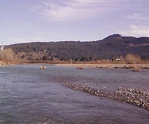
Mad River about 15 miles (24 km) above the mouth
|
|

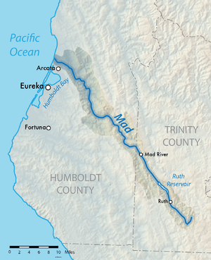
Map of the Mad River watershed
|
|
| Country | United States |
| State | California |
| Counties | Humboldt, Trinity |
| City | McKinleyville |
| Physical characteristics | |
| Main source | California Coast Ranges 4,845 ft (1,477 m) 40°12′20″N 123°9′23″W / 40.20556°N 123.15639°W |
| River mouth | Pacific Ocean 0 ft (0 m) 40°56′31″N 124°8′6″W / 40.94194°N 124.13500°W |
| Length | 113 mi (182 km) |
| Basin features | |
| Basin size | 497 sq mi (1,290 km2) |
| Tributaries |
|
The Mad River is an important river in Northern California. It flows for about 113 miles (182 km) from the Coast Range through Trinity and Humboldt counties. The river drains a large area of about 497 square miles (1,287 km²). It eventually flows into the Pacific Ocean near McKinleyville, north of Arcata.
Contents
River History
Before European settlers arrived in the mid-1800s, different Native American groups lived along the Mad River. The Wiyot people lived near the river's mouth, speaking a language related to Algonquian. Further upstream, groups like the Whilkut, Nongatl, and Lassik lived, speaking languages from the Athabascan family.
Today, the Blue Lake Rancheria and the Wiyot Tribe of the Table Bluff Reservation are recognized tribes. Sadly, other groups like the Whilkut, Nongatl, and Lassik were greatly impacted during the Bald Hills War in the 1860s. The river got its name in December 1849. This happened after Dr. Josiah Gregg got very angry when his exploration group didn't wait for him at the river's mouth.
River Features and Changes
The Mad River basin covers about 497 square miles (1,287 km²) of the Coast Range. It is about 100 miles (160 km) long and averages six miles (10 km) wide. The land rises from sea level at the mouth to about 6,000 feet (1,800 m) in the mountains where the river starts. Many smaller streams, called tributaries, flow into the Mad River. These include the South Fork Mad River, North Fork Mad River, and Maple Creek.
The river helps refill underground water supplies used for farming. Most of the river flows freely. However, Matthews Dam, located about a third of the way from the river's source, creates Ruth Reservoir. This dam is owned by the Humboldt Bay Municipal Water District. It provides water for cities like Eureka, Arcata, and Blue Lake. The reservoir can hold a lot of water, and it also helps generate electricity.
In the 1960s, there was a plan to build another dam on the Mad River. This project would have flooded a large area and harmed the river's health. However, people in the community strongly opposed it. Because of their efforts, the dam was never built.
River Health Concerns
One of the biggest problems for the Mad River is erosion. This causes too much sediment (like dirt and sand) to build up in the river. The main reasons for this erosion are too many roads and certain logging practices, especially older methods like clear-cutting. Also, removing plants along the riverbanks (called riparian vegetation) for ranching makes erosion worse. More buildings and cities also lead to lower water quality.
Because of these issues, the Mad River was listed as "sediment impaired" in 1992. This means it had too much sediment. In 2006, it was also listed as "temperature and turbidity-impaired," meaning the water was too warm and cloudy.
Land Use Around the River
The upper part of the river flows through the Six Rivers National Forest. However, most of the land around the river is privately owned. About 64 percent of this land is used for timber production. Green Diamond is the largest landowner in the area, owning about 42 percent of all the land. Other large landowners include R. Emmerson and Humboldt Redwood Company. Many ranchers and lumber companies also own smaller, but still significant, pieces of land. The rest of the land is used for homes, open spaces, and parks.
River Ecology: Plants and Animals
The Mad River is a great place for outdoor activities and provides important homes for many fish and wildlife. A special wildflower called the Mad River fleabane was named after the river.
Fish Species in the Mad River
Important fish species in the river include coho salmon (Oncorhynchus kisutch), Chinook salmon (O. tshawytscha), and steelhead (O. mykiss). These fish were listed as threatened in the Mad River between 1997 and 2000, meaning their populations are at risk.
Two other threatened fish, longfin smelt (Spirinchus thaleichthy) and eulachon (Thaleichthys pacificus), are also listed as being in the river's estuary (where it meets the ocean). However, they haven't been seen much in recent years.
The Mad River Estuary is a special place where young fish like juvenile rockfish and several types of flatfish, such as starry flounder (Platichthys stellatus), grow up. It's also a pathway for salmon and Pacific lamprey to migrate. Many marine species, like topsmelt and surf smelt, use the estuary for feeding in the summer. Other fish like Pacific staghorn sculpin and Three-spined stickleback live in the estuary all year.
Upstream from the estuary, the Mad River is home to coastal cutthroat trout, rainbow trout, and different types of sucker fish.
Other Wildlife
The Mad River watershed was home to many North American beaver (Castor canadensis) in 1954. These beaver were brought back to the North Fork Mad River in 1946, or they might have moved there from the Little River (Humboldt County). North American river otter (Lontra canadensis) were also common in the area. The Mad River Estuary is protected by the California Bays and Estuaries Policy because of its importance.
 | Emma Amos |
 | Edward Mitchell Bannister |
 | Larry D. Alexander |
 | Ernie Barnes |

